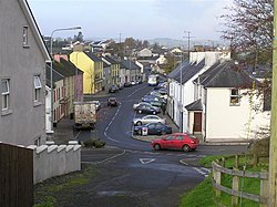
Drumquin

Last updated

Drumquin
Drumquin Village - geograph.org.uk - 1035629.jpg
United Kingdom Northern Ireland adm location map.svg
Red pog.svg
Drumquin
Location within Northern Ireland
Irish grid reference H329743
  Belfast 77 miles (124 km)
District
County
Country Northern Ireland
Sovereign state United Kingdom
Post town OMAGH
Postcode district BT78
Dialling code 028, +44 28
UK Parliament
NI Assembly
List of places
UK
Northern Ireland
Tyrone
54°36′58″N7°29′26″W / 54.616095°N 7.490444°W / 54.616095; -7.490444

Drumquin (Irish : Droim Caoin, meaning "pleasant ridge") [1] is a village and townland (of 398 acres) in County Tyrone, Northern Ireland. It lies between Omagh and Castlederg, on the banks of the Drumquin River (Fairywater). It is situated in the civil parishes of both Longfield West and Longfield East. [1] The main part of the village is located in Longfield East, in the townland of Drumnaforbe, whilst Longfield West is where its namesake townland Drumquin is located. Drumquin is in the historic barony of Omagh West. [2]

Contents

History

It has a rich and varied historical legacy with a Neolithic stone circle, a Holy Well, and the Giant's Stone on Dooish Mountain. The works of the noted Irish writer Benedict Kiely contain many references to the Drumquin district, with which he had family connections on his mother's side. In 1802, the countryside around Drumquin was described as one continuous scene of dreary mountains. However, the traveler did point out that forty years before that a rich coalmine had been opened at Drumquin and a canal opened to transport the coal. Drum quin has been in existence since 1211.

Sir John Davies founded the village itself in 1617, and the same gentleman built Castle Curlews, later called Castle Kirlish, the remains of which can be seen in the town land of that name. His agent was a man called Bradley, one of whose family was responsible in later times for the building of the fine stone house, which is a feature of the village today. Castle Kirlish was joined to Castlederg Castle by a straight causeway, which was seven miles (11 km) long. Traces of this causeway could still be observed in 1837.

Drumquin was also a staging town in the 19th and early 20th century for coaches and travellers who were making their way to Derry from Omagh and vice versa. As a result of this the village flourished and hosted a hotel and several shops. Felix Kearney immortalised this area with songs such as "The Hills Above Drumquin" and others. On 26 August 1920, during the Irish War of Independence, the Irish Republican Army (IRA) attacked the Royal Irish Constabulary (RIC) barracks in Drumquin. One RIC constable and one IRA volunteer were killed.

Geography

Bell tower at St Patrick's church, Drumquin Bell Tower at St Patrick's church, Drumquin - geograph.org.uk - 62057.jpg
Bell tower at St Patrick's church, Drumquin

The geography of the area is a mixture of flat fertile lands that clings to the banks of the Fairywater and steep rolling hills. There are also forests to the southwest of the village. Lough Bradan is also located roughly 7 miles from the village. The land is also covered in numerous rivers and streams, and two rivers meet on the outskirts of the village to form the river Fairywater.

The village itself is dominated by Dooish Mountain which is the highest point in the area. Close to the village Sloughan Glen Waterfalls can be found; these rest in a deep ravine. Beyond the townland of Bradan lies miles of wet bogland that stretch to the border with County Fermanagh. In the area of the glen the land rises dramatically before falling again into the Fermanagh countryside. The area in general is also dotted with several quarries, the biggest of these lying 2 miles outside of the village itself.

Sport

Traditional Games

Drumquin Wolfe Tones is the local Gaelic Athletic Association (GAA) club which has been in existence in its current form since 1968. Previous clubs have existed in various forms from the early 1930s. The club has experienced success in recent years at underage level, with teams at Under-14 level winning the double in 2018 and 2023 & teams at Minor level winning the double in 2018 and 2021. Underage teams (as low as Under-14 level) have won a combined 10 titles in the last 5 years.

Others

Drumquin United is a soccer club founded in 2007 by Sammy Dennison and Al Martin, after the administration of Drumquin Rovers which was run under the tutelage of Jason Thompson and Nuala Donnelly from 2000 until 2006. The U-13 team won the Grade 4 title in 2012.

Demography

19th century population

The population of the village decreased during the 19th century: [3] [4]

Year184118511861187118811891
Population352316354247221218
Houses716175515152

2011 Census

On Census day in 2011:

Drumquin townland

The townland is situated in the historic barony of Omagh West and the civil parish of Longfield West and covers an area of 398 acres. [5] The population of the townland declined during the 19th century: [3] [6]

Year184118511861187118811891
Population9110070787256
Houses221713161613

The village of Drumquin is in both the townland of the same name, and in townland of Drumnaforbe in the civil parish of Longfield East. In 1891 the village was estimated to cover an area of 12 acres. [3]

See also

Twin towns

Llantrisant has a twinning arrangement with:

Related Research Articles

<span class="mw-page-title-main">Castlederg</span> Human settlement in Northern Ireland

Castlederg is a town in County Tyrone, Northern Ireland. It lies on the River Derg and is near the border with County Donegal, Ireland. It stands in the townlands of Castlesessagh and Churchtown, in the historic barony of Omagh West and the civil parish of Urney. The village has a ruined castle and two ancient tombs known as the Druid's Altar and Todd's Den. It had a population of 2,980 people at the 2021 Census.

<span class="mw-page-title-main">Dromore, County Tyrone</span> Human settlement in Northern Ireland

Dromore is a town, townland and civil parish in County Tyrone, Northern Ireland. It is nine miles (14 km) south west of Omagh on the A32 and sixteen miles (26 km) from Enniskillen. The population of Dromore was 1,198 at the 2011 Census.

Benburb ) is a village and townland in County Tyrone, Northern Ireland. It lies 7.5 miles from Armagh and 8 miles from Dungannon. The River Blackwater runs alongside the village as does the Ulster Canal.

<span class="mw-page-title-main">Beragh</span> Village in County Tyrone, Northern Ireland

Beragh is a village and townland in County Tyrone, Northern Ireland. It is about 8 miles southeast of Omagh and is in the Fermanagh and Omagh District Council area. The 2001 Census recorded a population of 520.

<span class="mw-page-title-main">Caledon, County Tyrone</span> Village in County Tyrone, Northern Ireland

Caledon is a small village and townland in County Tyrone, Northern Ireland. It is in the Clogher Valley on the banks of the River Blackwater, 10 km from Armagh. It lies in the southeast of Tyrone and near the borders of County Armagh and County Monaghan. It is situated in the historic barony of Dungannon Lower and the civil parish of Aghaloo. In the 2001 Census it had a population of 387 people. It is a designated conservation area. It was historically known as Kinnaird.

<span class="mw-page-title-main">Altamuskin</span> Village in County Tyrone, Northern Ireland

Altamuskin or Altamooskan is a small village and townland in County Tyrone, Northern Ireland. It is situated in the historic barony of Clogher and the civil parish of Errigal Keerogue and covers an area of 1165 acres. In the 2014 Census Altamuskin had a population of 127 people. It lies within the Fermanagh and Omagh District Council area and is home to St Bridget's Altamuskin. The population of the townland declined during the 19th century:

<span class="mw-page-title-main">Dooish</span> Human settlement in Northern Ireland

Dooish is a village and townland near Drumquin in County Tyrone, Northern Ireland. The townland is situated in the historic barony of Omagh West and the civil parish of Longfield West and covers an area of 845 acres. In the 2001 Census it had a population of 93 people. It lies within the Omagh District Council area.

<span class="mw-page-title-main">Drumnakilly</span> Village in Northern Ireland

Drumnakilly .) is a small village and townland between Carrickmore and Omagh in County Tyrone, Northern Ireland. In the 2001 Census it had a population of 114 people. The townland is situated in the historic barony of Strabane Upper and the civil parish of Termonmaguirk and covers an area of 1,352 acres. It lies within the Omagh District Council area.

<span class="mw-page-title-main">Ardstraw</span> Village in County Tyrone, Northern Ireland

Ardstraw is a small village, townland and civil parish in County Tyrone, Northern Ireland, three miles northwest of Newtownstewart. In the 2001 Census it had a population of 222 people.

<span class="mw-page-title-main">Killen, County Tyrone</span> Human settlement in Northern Ireland

Killen is a small village and townland in County Tyrone, Northern Ireland. It is several miles southwest of Castlederg, on the road leading south over Scraghy Mountain. A short distance to the west lies County Donegal, in the Republic of Ireland. It is situated in the civil parish of Longfield West and the historic barony of Omagh West. In the 2001 Census it had a population of 231 people.

Drumquin Wolfe Tones is a Gaelic Athletic Association club in Drumquin, County Tyrone, Northern Ireland. They play their games at Jim McGirr Park, in the townland of Drumnaforbe, in the civil parish of Longfield East.

<span class="mw-page-title-main">Omagh West</span> Place in Northern Ireland, United Kingdom

Omagh West is a barony in County Tyrone, Northern Ireland. It is bordered by three other baronies in Northern Ireland: Strabane Lower to the north-east; Omagh East to the east; and Lurg to the south. It also borders two baronies in County Donegal in the Republic of Ireland: Tirhugh to the south-west; and Raphoe South to the north-west.

<span class="mw-page-title-main">Aghalunny</span> Townland in County Tyrone, Northern Ireland

Aghalunny is a townland in County Tyrone, Northern Ireland. It is situated in the historic barony of Omagh West and the civil parish of Termonamongan and covers an area of 493 acres.

<span class="mw-page-title-main">Bullock Park</span> Townland in County Tyrone, Northern Ireland

Bullock Park is a townland in County Tyrone, Northern Ireland. It is situated in the historic barony of Omagh West and the civil parish of Longfield West and covers an area of 398 acres.

<span class="mw-page-title-main">Doocrock</span> Townland in County Tyrone, Northern Ireland

Doocrock is a townland in County Tyrone, Northern Ireland. It is situated in the historic barony of Omagh East and the civil parish of Dromore and covers an area of 426 acres.

<span class="mw-page-title-main">Kilcroagh, County Tyrone</span> Townland in County Tyrone, Northern Ireland

Kilcroagh is a townland in County Tyrone, Northern Ireland, near Castlederg. It is situated in the historic barony of Omagh West and the civil parish of Urney and covers an area of 351 acres.

Cloncandra Glebe is a townland in County Tyrone, Northern Ireland. It is situated in the historic barony of Omagh East and the civil parish of Kilskeery and covers an area of 213 acres.

Mount Bernard is a townland in County Tyrone, Northern Ireland. It is situated in the barony of Omagh West and the civil parish of Urney and covers an area of 50 acres.

Longfield West is a civil parish in County Tyrone, Northern Ireland. It is situated in the historic barony of Omagh West.

References

  1. 1 2 "Droim Caoin/Drumquin". Placenames Database of Ireland . Retrieved 29 December 2023.
  2. "Drumquin". IreAtlas Townlands Database. Retrieved 12 May 2015.
  3. 1 2 3 "Census of Ireland 1851". Enhanced Parliamentary Papers on Ireland. Retrieved 21 March 2013.[ permanent dead link ]
  4. "Census of Ireland 1891". Enhanced Parliamentary Papers on Ireland. Retrieved 21 March 2013.[ permanent dead link ]
  5. "Townlands of County Tyrone". IreAtlas Townland Database. Retrieved 21 March 2013.
  6. "Census of Ireland 1891". Enhanced Parliamentary Papers on Ireland. Retrieved 21 March 2013.[ permanent dead link ]