Crossings
Kentucky (western)
| Image | Crossings | Carries | Location | Coordinates |
|---|---|---|---|---|
 | Smithland Bridge | Smithland | 37°08′54″N88°23′58″W / 37.148472°N 88.399526°W | |
| Interstate 24 Bridge (Livingston-Lyon County Line) | Lake City and Kuttawa | 37°03′36″N88°13′04″W / 37.060025°N 88.217885°W | ||
| Unnamed road bridge | Grand Rivers and Kuttawa | 37°01′49″N88°13′37″W / 37.030391°N 88.227020°W | ||
| Unnamed railroad bridge | Paducah and Louisville Railroad | |||
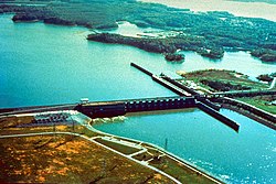 | Barkley Dam | Lake Barkley and Grand Rivers | 37°01′15″N88°13′24″W / 37.020696°N 88.223335°W | |
| Lake Barkley Bridge | Land Between the Lakes and Canton | 36°48′00″N87°58′39″W / 36.799975°N 87.977536°W | ||
Tennessee


Kentucky (eastern)
| Crossings | Carries | Location | Coordinates | |
|---|---|---|---|---|
| McMillans Ferry | Otia (Monroe County) | |||
| Hugh E. Spear Memorial Bridge | Burkesville | 36°44′47″N85°22′19″W / 36.746313°N 85.371953°W | ||
| Cumberland County Veterans Memorial Bridge | Burkesville | |||
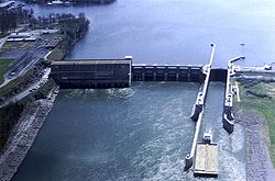
 | Wolf Creek Dam | Lake Cumberland | ||
| The Housebout Capital of the World Bridge | Bronston | |||
| General Burnside Bridge | Burnside | |||
| Unnamed rail bridge | Norfolk Southern Railway CNO&TP North District | Burnside | ||
 | Edward M. Gatliff Memorial Bridge | Cumberland Falls State Resort Park | ||
| Unnamed road bridge | ||||
| Croley Bend Bridge | Williamsburg | |||
| Edgar "Bud" Philpot Memorial Bridge | ||||
| Unnamed road bridge | ||||
| Unnamed railroad bridge | CSX Transportation KD Subdivision | |||
| Unnamed road bridge | ||||
| Yaden Bridge | Yaden | |||
| Louden Bridge | Louden | |||
| Unnamed road bridge | ||||
| Unnamed road bridge | ||||
| Unnamed road bridge | ||||
| Barbourville Bridge | Barbourville | |||
| Old Railroad Lane Bridge | Old Railroad Lane | Artemus | ||
| Artemus Bridge | ||||
| Flat Lick Bridge | Flat Lick | |||
| Unnamed road bridge | Flat Lick and Fourmile | |||
| Unnamed road bridge | Tinsley and Fourmile | |||
| William Lloyd Muncy Jr. Memorial Bridge | Fourmile | 36°47′32″N83°44′35″W / 36.792190°N 83.743070°W | ||
| E.J. Farris Memorial Bridge | Pineville | |||
 | Pine Street Bridge | |||
 | Joan Asher Cawood Bridge | Wasioto | ||
| Unnamed road bridge | Calvin | |||
| Unnamed road bridge | Miracle | |||
| Unnamed road bridge | Tejay | |||
| Unnamed road bridge | Hulen | |||
| Unnamed road bridge | Saylor Creek Road | Molus | ||
| Dixietown Vietnam Veterans Memorial Bridge | Coldiron | |||
| MSgt. James "Budd" Gordon Farmer Bridge | Wallins Creek | |||
| Cpl. Chad B. Lewis Memorial Bridge | Dayhoit | |||
| Unnamed rail bridge | CSX Transportation CV Subdivision | |||
| Unnamed road bridge | Park Hill Drive | Loyall | ||
| Moo Cow Curve Memorial Bridge | ||||
 | Unnamed rail bridge | CSX Transportation CV Subdivision | Baxter | |