Crossings
| Name | Carries | Right (west) bank | Left (east) bank | Image |
|---|---|---|---|---|
| logging road (46.10067732960245, -69.89544113038775) | Seboomook Lake, Maine: N Branch Rd | |||
| logging road (46.1495319127175, -69.88731216901594) | Seboomook Lake, Maine: 490 Rd | |||
| logging road (46.17494185379136, -69.84561622959055) | Seboomook Lake, Maine: unnamed road | |||
| logging road (46.28875732929241, -69.92917139710556) | Seboomook Lake, Maine: Baker Lake Road | |||
| Sunset Bridge on the St. Juste Road (T10R17) | Seboomook Lake, Maine: St. Juste Road | |||
| logging road (46.81042109811294, -69.57485639337969) | Northwest Aroostook, Maine: unnamed road | |||
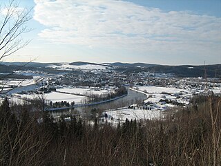
| Dickey Road | Allagash, Maine: Walker Brook Road | Allagash, Maine: SR 161 | Allagash, Maine: Walker Brook Road | |
| Clair-Fort Kent Bridge | Fort Kent, Maine: US 1 / SR 161 | Clair, New Brunswick: New Brunswick Route 205 |  | |
| Edmundston–Madawaska Bridge | Bridge Street | Madawaska, Maine: US 1 | Edmundston, New Brunswick: New Brunswick Route 120 |  |
| railway bridge | Maine Northern Railway (MNR Van Buren Subdivision) | Van Buren, Maine | Saint Leonard, New Brunswick | |
| Saint Leonard-Van Buren Bridge | Van Buren, Maine: US 1 | Saint Leonard, New Brunswick: New Brunswick Route 17 |  | |
| Grand Falls: Route 2, New Brunswick Route 218 | Grand Falls: Route 2, New Brunswick Route 108 | |||
| railway bridge | Multi-use trail (formerly Canadian Pacific Railway CP Edmundston Subdivision) | Grand Falls | Grand Falls | |
| Grand Falls: Route 130 | Grand Falls: New Brunswick Route 108 | |||
| Brooks Bridge | Brooks Bridge Road | Limestone | New Brunswick Route 105 | |
| Perth-Andover Bridge | Andover: Route 109 | Perth: New Brunswick Route 105, Route 109 |  | |
| Florenceville: Route 130, New Brunswick Route 110 | East Florenceville: Route 130, New Brunswick Route 105 | |||
| Florenceville Bridge | Old Florenceville Bridge | Florenceville: Route 110 | East Florenceville: New Brunswick Route 105 |  |
| Hugh John Flemming Bridge | Hartland: Route 130, New Brunswick Route 105 | Somerville: Route 130, New Brunswick Route 103 |  | |
| Hartland Bridge | Hartland Bridge Road | Hartland: New Brunswick Route 105 | Somerville: New Brunswick Route 103 |  |
| Grafton Bridge | Woodstock: Route 103 | Grafton: Route 105, Route 585 | ||
| Hawkshaw Bridge | Hawkshaw Bridge Road | Pokiok: New Brunswick Route 102 | New Brunswick Route 105 | |
| Westmorland Street Bridge | Westmorland Street | Fredericton: New Brunswick Route 101, New Brunswick Route 102 | Fredericton: New Brunswick Route 105 | 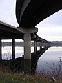 |
| Fredericton Railway Bridge (now Bill Thorpe Walking Bridge) | Multi-use trail (formerly Canadian National Railway CN Nashwaak Subdivision) | Fredericton | South Devon |  |
| Princess Margaret Bridge | Fredericton: Route 8 | Fredericton: Route 8, New Brunswick Route 10, New Brunswick Route 105 |  | |
| Burton Bridge | Burton Bridge | Oromocto: New Brunswick Route 102 | Maugerville: New Brunswick Route 105 | |
| Saint John River High Level Crossing | Arcadia: Route 2, New Brunswick Route 102 | Canning: Route 2, New Brunswick Route 105 | ||
| Gagetown Ferry (cable ferry) | Arcadia: New Brunswick Route 102 | Lower Jemseg: New Brunswick Route 715 | ||
| Evandale Ferry (cable ferry) | Evandale: New Brunswick Route 102 | Route 124 | ||
| Westfield Ferry (cable ferry) | Westfield: New Brunswick Route 177 | Hardings Point: New Brunswick Route 845 |  | |
| Reversing Falls Railway Bridge | New Brunswick Southern Railway (NBSR McAdam Subdivision) | Lancaster | Saint John |  |
| Reversing Falls Bridge | Lancaster: Route 100 | Saint John: Route 100 |  | |
| Saint John Harbour Bridge | Saint John: Route 1 | Saint John: Route 1, New Brunswick Route 100 |  | |
| Mactaquac Dam | Mactaquac Road (Route 102) | Lower Kingsclear / French Village: Ramps for Route 102 | Mckeens Corner: Route 105 |