List of electoral wards in Gwynedd

Last updated
County of Gwynedd from 1974 WalesGwynedd1974.png
County of Gwynedd from 1974

This list of electoral wards in Gwynedd includes council wards which elect (or have elected) councillors to the local authorities in the county of Gwynedd, Wales.

The wards and electoral divisions in the United Kingdom are electoral districts at sub-national level represented by one or more councillors. The ward is the primary unit of English electoral geography for civil parishes and borough and district councils, electoral ward is the unit used by Welsh principal councils, while the electoral division is the unit used by English county councils and some unitary authorities. Each ward/division has an average electorate of about 5,500 people, but ward-population counts can vary substantially. As at the end of 2014 there were 9,456 electoral wards/divisions in the UK.

Gwynedd A county in Wales, adjacent to Powys, Conwy, Anglesey, and Ceredigion

Gwynedd is a county in Wales, sharing borders with Powys, Conwy, Denbighshire, Anglesey over the Menai Strait, and Ceredigion over the River Dyfi. The scenic Llŷn Peninsula and most of Snowdonia National Park are in Gwynedd. Bangor is the home of Bangor University. In the northern part of the county, the other main settlements are Caernarfon, Bethesda, Ffestiniog, Llanddeiniolen, Llanllyfni, Porthmadog and Pwllheli. The largest settlement in the south is Tywyn.

Wales Country in northwest Europe, part of the United Kingdom

Wales is a country that is part of the United Kingdom and the island of Great Britain. It is bordered by England to the east, the Irish Sea to the north and west, and the Bristol Channel to the south. It had a population in 2011 of 3,063,456 and has a total area of 20,779 km2 (8,023 sq mi). Wales has over 1,680 miles (2,700 km) of coastline and is largely mountainous, with its higher peaks in the north and central areas, including Snowdon, its highest summit. The country lies within the north temperate zone and has a changeable, maritime climate.

Contents

Gwynedd was created with the merger of Anglesey with Caernarfonshire and Merionethshire in 1974, led by Gwynedd County Council. In 1996 Anglesey became a separate county and the District of Aberconwy passed to Conwy County Borough, The new Gwynedd local authority renamed itself Gwynedd Council.

Anglesey Island in Wales

Anglesey is an island off the north coast of Wales with an area of 276 square miles (715 km2). Anglesey is by far the largest island in Wales and the seventh largest in the British Isles. Anglesey is also the largest island in the Irish Sea by area, and the second most populous island. The ferry port of Holyhead handles more than 2 million passengers each year. The Menai Suspension Bridge, designed by Thomas Telford in 1826, and the Britannia Bridge span the Menai Strait to connect Anglesey with the mainland.

Caernarfonshire former administrative county of Wales

Caernarfonshire, historically spelled as Caernarvonshire or Carnarvonshire in English, is one of the thirteen historic counties, a vice-county and a former administrative county of Wales.

Merionethshire historic county of Wales

Merionethshire or Merioneth is one of thirteen historic counties of Wales, a vice county and a former administrative county.

Since 2004 there have been 71 county wards returning 75 county councillors to Gwynedd Council.

Wards of Gwynedd County Council

19731989

From the 1973 county election there were 64 wards, all except two of them elected one county councillor to the new Gwynedd County Council. The Bangor No.1 and the Ogwen wards elected two councillors. [1]

Ogwen (electoral ward)

Ogwen is the name of an electoral ward covering part of the village and community of Bethesda in Gwynedd, Wales. It elects councillors to the community council and Gwynedd Council.

19891996

Following The County of Gwynedd (Electoral Arrangements) Order 1988 the number of wards were decreased to 62, each electing one county councillor to Gwynedd County Council, taking effect from the May 1989 elections. [2]

In Borough of Aberconwy   
Bro Machno

Bro Machno is a community in Conwy County Borough, in Wales, formed from the former civil parish of Penmachno. It covers the Penmachno Valley, through which runs the Afon Machno, and includes the villages of Penmachno and Cwm Penmachno. To the south west borders Gwynedd, and is located 4.8 miles (7.7 km) south of Betws-y-Coed, 21.8 miles (35.1 km) north west of Corwen, and 19.4 miles (31.2 km) south of Conwy. The whole of the community is within the Snowdonia national park, while much of it forms part of Gwydir Forest. According to the 2011 census, the population of the Bro Machno Parish was 617, of whom 342 (55%) were able to speak Welsh and 214 (34%) had no skills in Welsh.

Caerhun scattered rural community and former civil parish in Conwy County Borough, Wales

Caerhun is a scattered rural community, and former civil parish, on the west bank of the River Conwy. It lies to the south of Henryd and the north of Dolgarrog, in Conwy County Borough, Wales, and includes the villages of Llanbedr-y-cennin, Rowen, Tal-y-bont and Ty'n-y-groes. It was formerly in the historic county of Caernarvonshire. At the 2001 census, it had a population of 1,200, increasing to 1,292 at the 2011 census.

Conwy town in Wales

Conwy (Welsh pronunciation: ['kɔnwɨ̞], Welsh pronunciation: ['kɔnwi], traditionally known in English as Conway, is a walled market town and community in Conwy County Borough on the north coast of Wales. The town, which faces Deganwy across the River Conwy, formerly lay in Gwynedd and prior to that in Caernarfonshire. The community, which includes Deganwy and Llandudno Junction, had a population of 14,208 at the 2001 census, and is a popular tourist destination. The population rose to 14,753 at the 2011 census. In the 2015 census "The size of the resident population in Conwy County Borough on the 30th June 2015 was estimated to be 116,200 people." The town itself has a population of 4,065.

In Borough of Arfon   
Bethesda, Gwynedd town in Gwynedd, north Wales

Bethesda is a town and community on the River Ogwen and the A5 road on the edge of Snowdonia, in Gwynedd, north-west Wales. It is the 5th largest Community in Gwynedd.

Llanddeiniolen

Llanddeiniolen is a community in the county of Gwynedd, Wales, and is 124 miles (200 km) from Cardiff and 206 miles (332 km) from London. The community also includes the villages of Rhiwlas, Dinorwig, Bethel, Brynrefail, Penisarwaun, and Deiniolen. In 2011 the population of Llanddeiniolen was 5072 with 76.2% of them able to speak Welsh.

Llandwrog human settlement in United Kingdom

Llandwrog is a village and community in Gwynedd, north-west Wales, most notable for the presence of the headquarters of Welsh record label Sain and the site of Caernarfon Airport. It has a population of 2,466, increasing to 2,539 at the 2011 Census. The community includes the villages of Groeslon, Carmel, Gwynedd, Y Fron, Dinas Dinlle, and Cilgwyn.

In District of Dwyfor
In District of Meirionnydd
In Ynys Mon-Isle of Anglesey

Wards of Gwynedd Council

County of Gwynedd from 1996 WalesGwynedd.png
County of Gwynedd from 1996

19952004

The first elections to the new Gwynedd Council took place in 1995. Eighty three county councillors were elected from sixty nine electoral wards. [3] as follows (numbers of councillors in brackets):

2004

County wards of Gwynedd from 2004 Gwynedd UK ward map (blank).svg
County wards of Gwynedd from 2004

Following The County of Gwynedd (Electoral Changes) Order 2002 the number of wards were increased to 71, electing 75 councillors, taking effect from the 2004 elections. [4] Forty-five wards remained unchanged, eight wards had their boundaries amended and a further four had their representation reduced from two councillors to one. [5] Most communities in the county also have a community council and community wards.

WardCounty
Coun
cillors
Communities (and community wards) included
Aberdaron 1Aberdaron*
Aberdovey 1Aberdovey*
Pennal*
Abererch 1 Llannor* (Abererch and Y Ffôr wards)
Abersoch 1 Llanengan* (Abersoch ward) )
Arllechwedd 1 Aber and Llanllechid*
Llandygai* (Llandygai ward)
Bala 1Bala (town)*
Barmouth 1Barmouth (town)*
Bethel 1Llanddeiniolen* (Bethel ward)
Bontnewydd 1Bontnewydd*
Botwnnog 1Botwnnog*
Bowydd and Rhiw 1 Ffestiniog* (Bowydd and Rhiw and Tanygrisiau wards)
Brithdir and Llanfachreth/Y Ganllwyd/Llanelltyd 1 Brithdir and Llanfachreth*
Ganllwyd*
Llanelltyd*
Bryncrug/Llanfihangel 1Bryn-crug*
Llanfihangel-y-Pennant*
Cadnant 1 Caernarfon (town)* (Dwyrain ward)
Clynnog Fawr 1Clynnog*
Corris/Mawddwy 1 Corris*
Mawddwy*
Criccieth 1Criccieth*
Cwm y Glo 1 Llanrug* (Ceunant and Cwm y Glo wards)
Deiniol 1 Bangor (city)* (Deiniol ward)
Deiniolen 1 Llanddeiniolen* (Clwt y Bont, Deiniolen and Dinorwig wards)
Dewi1 Bangor (city)* (Dewi ward)
Diffwys and Maenofferen 1 Ffestiniog* (Diffwys and Maenofferen ward)
Dolbenmaen 1Dolbenmaen* (Bryncir, Garn, Golan, Penmorfa and Treflys wards)
Dolgellau North 1 Dolgellau (town)* (Northern and Rural wards)
Dolgellau South 1 Dolgellau (town)* (Southern wards)
Dyffryn Ardudwy 1Dyffryn Ardudwy*
Efailnewydd/Buan 1 Buan*
Llannor* (Efail-newydd and Pentre-uchaf wards)
Garth1 Bangor (city)* (Garth Ward)
Gerlan 1 Bethesda (town)* (Gerlan and Rachub wards)
Glyder 1 Bangor (city)* (Glyder ward)
Groeslon 1 Llandwrog* (Dinas Dinlle and Groeslon wards)
Harlech and Talsarnau 1Harlech*
Talsarnau*
Hendre 1 Bangor (city)* (Hendre ward)
Hirael 1 Bangor (city)* (Hirael ward)
Llanaelhaearn 1Llanaelhaearn*
Pistyll*
Llanbedr 1Llanbedr*
Llanfair*
Llanbedrog 1Llanbedrog*
Llanberis 1Llanberis*
Llandderfel 1Llandderfel*
Llanycil*
Llanengan 1Llanengan* (Llanengan and Llangian wards)
Llangelynin 1 Arthog*
Llanegryn*
Llangelynin*
Llanllyfni 1Llanllyfni* (Llanllyfni, Nantlle and Nebo wards)
Llanrug 1Llanrug* (Llanrug ward)
Llanwchllyn 1Llanwchllyn*
Llangywer*
Llanwnda 1Llanwnda*
Llanystumdwy 1Llanystumdwy*
Marchog 2 Bangor (city)* (Marchog ward)
Menai (Bangor) 2 Bangor (city)* (Menai ward )
Menai (Caernarfon) 1 Caernarfon (town)* (Menai ward)
Morfa Nefyn 1Nefyn (town)* (Edern and Morfa Nefyn wards)
Nefyn 1Nefyn (town)* (Nefyn ward)
Ogwen1Bethesda* (Ogwen ward)
Peblig 1 Caernarfon (town)* (Deheuol ward)
Penisarwaun 1 Llanddeiniolen* (Brynrefail, Penisarwaun and Rhiwlas wards)
Penrhyndeudraeth 1 Llanfrothen*
Penrhyndeudraeth*
Pentir 1Pentir*
Penygroes 1 Llanllyfni* (Penygroes ward)
Porthmadog East 1 Porthmadog (town)* (East and Ynys Galch wards)
Porthmadog West 1 Porthmadog (town)* (Gest, Morfa Bychan and West wards)
Porthmadog - Tremadog 1 Beddgelert*
Dolbenmaen* (Prenteg ward)
Porthmadog (town)* (Tremadog ward)
Pwllheli North 1 Pwllheli (town)* (North ward)
Pwllheli South 1 Pwllheli (town)* (South ward)
Seiont 2 Caernarfon (town)* (Gorllewin ward)
Talysarn 1 Llandwrog* (Carmel and Cesarea wards)
Llanllyfni* (Talysarn ward)
Teigl 1Ffestiniog* (Conglywal and Cynfal and Teigl wards)
Trawsfynydd 1 Maentwrog*
Trawsfynydd*
Tregarth and Mynydd Llandygai 1Llandygai* (St Ann's and Tregarth wards)
Tudweiliog 1Tudweiliog*
Tywyn 2Tywyn (town)*
Waunfawr 1 Betws Garmon*
Waunfawr
Y Felinheli 1Y Felinheli*

*= Communities which elect a community council

See also

Related Research Articles

Isle of Anglesey County Council British administrative body

The Isle of Anglesey County Council is the governing body for the county of Anglesey, one of the unitary authority areas of Wales. The council has 30 councillors who represent 11 multi-member electoral wards.

Gwynedd Council

Gwynedd Council is the governing body for the principal area of Gwynedd, one of the subdivisions of Wales within the United Kingdom. The Council administrates internally through the medium of Welsh.

Rhosyr community in Anglesey, in north-west Wales

Rhosyr is a community in the far southern corner of Anglesey, Wales. It includes the villages of Dwyran and Newborough and Llangaffo.

Twrcelyn commote on the island of Anglesey, north Wales, part of the cantref of Cemais

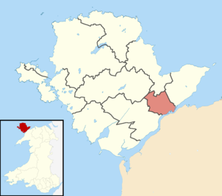
Twrcelyn is an electoral ward in the north of Anglesey, Wales. It includes the communities of Amlwch, Llanbadrig, Llaneilian, and Rhosybol. Twrcelyn elects three county councillors to the Isle of Anglesey County Council.

The Isle of Anglesey electoral boundary changes in 2012 reduced the numbers of electoral wards to the Isle of Anglesey County Council from 40 to 11. This led to the postponement of local government elections in the county by 12 months. The changes were confirmed by the Isle of Anglesey Order 2012 in October 2012.

Lligwy

Lligwy is an electoral ward on the northeast coast of Anglesey, Wales. It includes the communities Moelfre, Llaneugrad, Llanfair-Mathafarn-Eithaf and Pentraeth; and the electoral ward of Llanfihangel Tre'r Beirdd in the community of Llanddyfnan. Lligwy elects three county councillors to the Isle of Anglesey County Council.

Canolbarth Môn

Canolbarth Môn is an electoral ward in the centre of Anglesey, Wales. It includes the communities of Bryngwran, Bodffordd, Llangefni, and Trewalchmai, and the majority of Llanddyfnan. Canolbarth Môn elects three county councillors to the Isle of Anglesey County Council.

Bro Aberffraw

Bro Aberffraw is an electoral ward in the southern corner of Anglesey, Wales. It comprises the three communities of Aberffraw, Bodorgan and Rhosyr. Canolbarth Môn elects two county councillors to the Isle of Anglesey County Council.

Tudno (electoral ward)

Tudno is the name of one of the electoral wards in Llandudno, Conwy County Borough, Wales. It is the middle of the five town wards and covers the town immediately east of the branch line to Llandudno railway station. Mostyn ward lies to the west and Craig-y-Don ward lies to the east, with Llandudno beach to the north.

Llanwenarth Ultra

Llanwenarth Ultra is an electoral ward near Abergavenny, Monmouthshire. The ward elects councillors to Llanfoist Fawr Community Council and Monmouthshire County Council.

Bro Rhosyr

Bro Rhosyr is an electoral ward in the south of Anglesey, Wales, created in 2012.

Aethwy (electoral ward)

Aethwy is the name of an electoral ward in the south of Anglesey, Wales, created in 2012. It contains the population centres of Menai Bridge and Llanfair PG.

Ynys Gybi is the name of an electoral ward in the west of Anglesey, Wales, created in 2012. It covers the most part of Holy Island, whose name is Ynys Gybi in Welsh.

Mid Glamorgan County Council

Mid Glamorgan County Council was the local authority administering the Welsh county of Mid Glamorgan between 1974 and 1996.

Peblig, Caernarfon

Peblig is an electoral ward in the town of Caernarfon, Gwynedd, Wales, electing councillors to the town council and Gwynedd Council.

Penrhyn (electoral ward)

Penrhyn is the name of one of the electoral wards in Llandudno, Conwy County Borough, Wales. It is the easternmost of the five town wards and primarily covers the large village of Penrhyn Bay. The Llandudno ward of Craig-y-Don lies to the west, with Llandrillo yn Rhos to the east.

Menai (Caernarfon ward)

Menai is the name of an electoral ward in the town of Caernarfon, Gwynedd, Wales. As the name suggests, it borders the Menai Strait. The ward elects councillors to the town council and Gwynedd Council.

Narberth (electoral ward)

Narberth is the name of an electoral ward in Pembrokeshire, Wales. Since 1995 it has elected one councillor to Pembrokeshire County Council.

References

  1. "Gwynedd County Council Election Results 1973-1993" (PDF). The Elections Centre (Plymouth University). Retrieved 20 April 2019.
  2. "The County of Gwynedd (Electoral Arrangements) Order 1988". legislation.gov.uk. The National Archives. 5 May 1988. Retrieved 20 April 2019.
  3. "Gwynedd Council Election Results 1995-2012" (PDF). The Elections Centre (Plymouth University). Retrieved 19 April 2019.
  4. "The County of Gwynedd (Electoral Changes) Order 2002 - Schedule". legislation.gov.uk. The National Archives. 6 December 2002. Retrieved 19 April 2019.
  5. "The County of Gwynedd (Electoral Changes) Order 2002 - Explanatory Note". legislation.gov.uk. The National Archives. 6 December 2002. Retrieved 19 April 2019.