See also
| By province | |
|---|---|
| Types | |
| See also | |
There are many hill stations in Pakistan, where there is snow in the winter. In the summer, the temperatures are much cooler than the hot areas of Punjab and Sindh. People from all over the country flock to these hill stations to enjoy the snow in winters, and to enjoy the cool summers away from the hot plains. The following is a list of hill stations:
| By province | |
|---|---|
| Types | |
| See also | |

Afghanistan is a landlocked mountainous country located within Central and South Asia, also sometimes included as part of the Middle East. The country is the 40th largest in the world in size. Kabul is the capital and largest city of Afghanistan, located in the Kabul Province. Strategically located at the crossroads of major trade routes, Afghanistan has attracted a succession of invaders since the sixth century BCE.

The desert climate, is a climate in which there is an excess of evaporation over precipitation. The typically bald, rocky, or sandy surfaces in desert climates hold little moisture and evaporate the little rainfall they receive. Covering 14.2% of earth's land area, hot deserts are the most common type of climate on earth after polar climate.

Continental climates often have a significant annual variation in temperature. They tend to occur in the middle latitudes, where prevailing winds blow overland, and temperatures are not moderated by bodies of water such as oceans or seas. Continental climates occur mostly in the Northern Hemisphere, which has the kind of large landmasses on temperate latitudes required for this type of climate to develop. Most of northern and northeastern China, eastern and southeastern Europe,Western and north western Iran central and southeastern Canada, and the central and northeastern United States have this type of climate.

A mountain resort is a place to holiday or vacation located in a mountainous area. The term includes ski resorts, where winter sports, including skiing, snowboarding, ice climbing and ice skating are practiced, as well as places where summer activities such as mountain biking, mountain boarding, and hiking are pursued. In hot climates hill and mountain resorts are visited for the cooler temperatures at higher elevations.

Shimla, also known as Simla, is the capital and the largest city of the Indian state of Himachal Pradesh. In 1864, Shimla was declared as the summer capital of British India, succeeding Murree, northeast of Rawalpindi. After independence, the city became the capital of Punjab and was later made the capital of Himachal Pradesh. It is the principal commercial, cultural and educational centre of the state. It was the capital city of British Burma from 1942 to 1945.

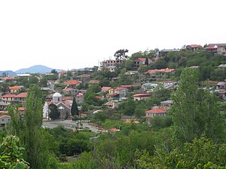
Murree is a mountain resort town, located in the Galyat region of the Pir Panjal Range, within the Rawalpindi District of Punjab, Pakistan. It forms the outskirts of the Islamabad-Rawalpindi metropolitan area, and is about 30 km (19 mi) northeast of Islamabad. It has average altitude of 2,291 metres (7,516 ft).
Prodromos is the highest village in Cyprus at 1,380 metres (4,530 ft) above sea level. It is the island's main centre for winter sport, with three ski slopes located on nearby Mount Olympus. The village is part of the Limassol District. The number of inhabitants has decreased steadily over the years; by the 2011 census there were only 123 permanent residents, although there are over 240 residences that are temporarily occupied, mostly during the summer and other holidays.

Thandiani is a hill station in the Galyat area of Khyber Pakhtunkhwa the Province of Pakistan. Thandiani is located in the northeast of Abbottabad District and is about 37.5 kilometres (23.3 mi) from Abbottabad in the foothills of the Himalayas. To the east beyond the Kunhar River lies the snow-covered Pir Panjal mountain range of Kashmir. Visible to the north and northeast are the mountains of Kohistan and Kaghan. To the northwest are the snowy ranges of Swat and Chitral. The hills of Thandiani are about 2,750 metres (9,020 ft) above sea level. Most of the people residing here belong to the Sadaat (Syed), Awan, Mughals, Qureshi, Abbasi, Jadoon Gujjar, and Karlal tribes. The nearest villages are Bandi Sarara Mara Rehmat Khan, Inderseri, Birnagalli, Chattri, Chamaili, Sialkot, Pattan, Okharela, Dheri, Darer and Kukmang.

Ayubia National Park, also known as Ayubia, is a protected area of 3,312 hectares (33 km2) located in Abbottabad District, Khyber Pakhtunkhwa province, Pakistan. It was declared a national park in 1984. Ayubia was named after Muhammad Ayub Khan (1958–1969), second President of Pakistan. The area supports temperate coniferous forest and temperate broadleaf and mixed forest ecoregion habitats, with an average elevation of 8,000 feet (2,400 m) above sea level.

Ajristan also spelled Ajeristan, is a district in the western part of Ghazni Province, Afghanistan. Its population was estimated at 62,028 in 2001, of which 90% areHazara people with others from the Pashtun people. Sangar, in the center of the district, is the capital. Most of the population live in the Jikhai River valley and depend upon agriculture, the main source of its economy. The last decade of severe winters and droughts have affected the economy and quality of life..

Kalam is a valley located at distance of 99 kilometres (62 mi) from Mingora in the northern upper reaches of Swat valley along the bank of Swat River in Khyber Pakhtunkhwa province of Pakistan. Kalam is surrounded by lush green hills, thick forests and bestowed with mesmeric lakes, meadows and waterfalls which are worth seen features of the landscape. It is the birthplace of Swat river which forms with confluence of two major tributaries of Gabral river and Ushu river.
Fort Munro, also known as Tuman Leghari, is a hill station, located at a height of 6,470 feet (1,970 m) above sea level in Dera Ghazi Khan. It attracts many people for short stays during the hot summer. It is around 85 kilometres from Dera Ghazi Khan city, Punjab, Pakistan and about 185 kilometres from Multan in Sulaiman Mountain range. The people of Fort Munro are nomads, especially of the Leghari tribe.
Australia's climate is governed mostly by its size and by the hot, sinking air of the subtropical high pressure belt. This moves north-west and north-east with the seasons. The climate is variable, with frequent droughts lasting several seasons, thought to be caused in part by the El Niño-Southern Oscillation. Australia has a wide variety of climates due to its large geographical size. The largest part of Australia is desert or semi-arid. Only the south-east and south-west corners have a temperate climate and moderately fertile soil. The northern part of the country has a tropical climate, varying between grasslands and desert. Australia holds many heat-related records: the continent has the hottest extended region year-round, the areas with the hottest summer climate, and the highest sunshine duration.

Dras, a tourist hub for its high altitude trekking routes and tourist sites, is a Hill Station in the Kargil district of the union territory of Ladakh in India. It is on the NH 1 between Zoji La pass and Kargil town. It is often called "The Gateway to Ladakh". The government's official spelling of the town is Drass.

The Siberian ibex, also known as the Altai ibex or Gobi ibex, is a species of ibex that lives in central Asia. It has traditionally been treated as a subspecies of the Alpine ibex, and whether it is specifically distinct from other ibex is still not entirely clear. It is the longest and heaviest member of the genus Capra, though its shoulder height is surpassed by the markhor.

Italy has a variety of climate systems. The inland northern areas of Italy have a relatively cool, mid-latitude version of the Humid subtropical climate, while the coastal areas of Liguria and the peninsula south of Florence generally fit the Mediterranean climate profile.
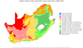
The climate of South Africa is determined by South Africa's situation between 22°S and 35°S, in the Southern Hemisphere's subtropical zone, and its location between two oceans, Atlantic and the Indian.

Chuyer is a commune in the Loire department in central France. It is a relatively small village outside Pelussin in the Mont Pilat national park.
The province of Sindh is situated in a subtropical region; it is hot in the summer and cold in winter. Temperatures frequently rise above 46 °C (115 °F) between May and August, and the minimum average temperature of 2 °C (36 °F) occurs during December and January. The annual rainfall averages about nearly nine inches, falling mainly during June and September. The southwesterly monsoon wind begins to blow in mid-February and continues until the end of September, whereas the cool northerly wind blows during the winter months from October to January.

Azad Kashmir is Administrative region of Pakistan situated in Northern part of the country. The northern part of Azad Jammu and Kashmir encompasses the lower part of the Himalayas, including Jamgarh Peak. However, Sarwali peak in the Neelum Valley is the highest peak in the state. Fertile, green, mountainous valleys are characteristic of Azad Kashmir's geography, making it one of the most beautiful regions on the subcontinent.