The following is a list of hospitals in Tajikistan that includes the name, location and references. [2] Tajikistan government sources indicate that there were 325 hospitals in Tajikistan in 1986. [3] By 2007, the number of hospitals had grown to 426, according to the World Health Organization. [4]
Name | City/Coordinate | Region | References |
---|---|---|---|
Central District Hospital Kolhozabad | Kolkhozobod, Rumi District | Khatlon Region | [2] |
Central District Hospital Qumsangir | Qumsangir District | Khatlon Region | [2] |
Central District Hospital Konibodom | Konibodom 40°16′42″N70°25′51″E / 40.278426°N 70.430960°E | Sughd Region | [2] |
Central District Hospital Qabodiyan | Qabodiyon District | Khatlon Region | [2] |
Isfara District Central Hospital | Isfara 40°07′00″N70°37′17″E / 40.116697°N 70.621493°E | Sughd Region | [2] [5] [6] |
Istaravshan District Central Hospital | Istaravshan | Sughd Region | [2] |
Central District Hospital Jirgatol | Jirgatol District (village) | Districts of Republican Subordination | [2] |
Central District Hospital Zafarabad | Zafarabad (village), Zafarabad District | Sughd Region | [2] |
Central District Hospital Jilikul | Dusti (Jilikul District) 37°29′13″N68°31′47″E / 37.487027°N 68.529606°E | Khatlon Region | [2] |
Central Hospital Dangara | Dangara (village) 38°06′04″N69°20′05″E / 38.101052°N 69.334662°E | Khatlon Region | [2] |
Central Hospital of Kulob | Kulob | Khatlon Region | [2] |
Central Hospital of Kurgan-Tube | Kurgan-Tube (formerly Qurghonteppa Oblast) | Khatlon Region | [2] |
Central Hospital Kayrakkum | Kayrakkum Reservoir (near) | Sughd Region | [2] |
Central District Hospital Muminabad | Muminabad (village) | Khatlon Region | [2] |
Matcha District Central Hospital | Mastchoh District (Matcha) 40°22′05″N69°19′31″E / 40.368056°N 69.325278°E | Sughd Region | [2] |
Central District Hospital of Nau | Nau (village of Spitamen) | Sughd Region | [2] |
Nurobad District Central Hospital | Nurobad District (village of Darband) | Districts of Republican Subordination | [2] |
Central District Hospital Parharskogo | Parharksky (village of Parkhar (probably Farkhar | Khatlon Region | [2] |
Central Hospital Nurak | Nurak | Khatlon Region | [2] |
Central Hospital Penjikent | Panjakent | Sughd Region | [2] |
Panj District Central Hospital | Panj District | Khatlon Region | [2] |
Central District Hospital named after A. Jami | Abdurrahman Jami area | Khatlon Region | [2] |
Central District Hospital named after B. Gafurov | Kurgan-Tube (B. Gafurov Area) | Khatlon Region | [2] |
Republican Ophthalmologic Center | 238 R. Nabiyev St. | Dushanbe | [2] |
Children's Surgical Hospital | 4 Gorky St. | Dushanbe | [2] |
Children's TB Hospital | 45 Azizbayov St. | Dushanbe | [2] |
Children's Regional Hospital | Khujand | Sughd Region | [2] |
Children's Hospital №2 | 133 Rudaki Ave. 38°36′02″N68°47′13″E / 38.600553°N 68.786883°E | Dushanbe | [2] |
Children's Hospital of Infectious Diseases | 20 Sheroz St. 38°34′15″N68°46′53″E / 38.570937°N 68.781390°E | Dushanbe | [2] |
City Clinical Hospital №1 | Abay St. 38°32′22″N68°45′08″E / 38.539551°N 68.752286°E | Dushanbe | [6] |
City Clinical Hospital №2 | 33 Sano St. | Dushanbe | [2] |
City Clinical Hospital №3 | 3 and 6 Akademika Radjabov St. | Dushanbe | [2] [7] |
City Hospital №2 | Khujand 40°15′57″N69°38′32″E / 40.265729°N 69.642123°E | Sughd Region | [2] [6] |
City Clinical Hospital S. Urunova (№1) | Khujand, S. Urunova, 147a Gagarina St. 40°16′27″N69°38′40″E / 40.274275°N 69.644526°E | Sughd Region | [2] |
Khorog General Hospital | Khorog | Gorno-Badakhshan Autonomous Region | [8] |
Leninski Mental Hospital | Dushanbe | [9] | |
International Ibn Sina Clinic | 38°34′54″N68°46′57″E / 38.581548°N 68.782413°E | Dushanbe | [10] [11] [12] [6] |
Aga Khan Health Service | Khorog 37°29′24″N71°34′59″E / 37.489990°N 71.583059°E | Gorno-Badakhshan Autonomous Region | [10] |
Prospekt Medical Clinic | Dushanbe | [10] | |
Nurafzo Diagnostic Centre | Dushanbe | [10] | |
Ananda SPA and Vendanta Medical Centre | 38°35′14″N68°47′49″E / 38.587086°N 68.796899°E | Dushanbe | [10] |
Hospital Istiqlol | ул. Н.Карабоев 61 38°32′10″N68°45′52″E / 38.536056°N 68.764395°E | Dushanbe | [1] |
Central Military Hospital of the Ministry of Defense | Dushanbe, 40 Years of Victory 1 38°32′15″N68°46′01″E / 38.537478°N 68.766963°E | Dushanbe | [6] |
Maternity Hospital № 1 (formerly № 3) | Mirzo Tursunzoda Street 38°34′55″N68°43′59″E / 38.581905°N 68.732939°E | Dushanbe | [6] [13] |
Tajikistan, officially the Republic of Tajikistan, is a landlocked country in Central Asia. It has an area of 143,100 km2 (55,300 sq mi) and an estimated population of 9,749,625 people. Its capital and largest city is Dushanbe. It is bordered by Afghanistan to the south, Uzbekistan to the west, Kyrgyzstan to the north, and China to the east. It is separated narrowly from Pakistan by Afghanistan's Wakhan Corridor. The traditional homelands of the Tajiks include present-day Tajikistan as well as parts of Afghanistan and Uzbekistan.
Dushanbe is the capital and largest city of Tajikistan. As of January 2020, Dushanbe had a population of 863,400 and that population was largely Tajik. Until 1929, the city was known in Russian as Dyushambe, and from 1929 to 1961 as Stalinabad, after Joseph Stalin. Dushanbe is located in the Gissar Valley, bounded by the Gissar Range in the north and east and the Babatag, Aktau, Rangontau and Karatau mountains in the south, and has an elevation of 750–930 m. The city is divided into four districts, all named after historical figures: Ismail Samani, Avicenna, Ferdowsi, and Shah Mansur.
Emomali Rahmon has been the 3rd President of Tajikistan since 16 November 1994. Previously he was the Chairman of the Supreme Assembly of Tajikistan, as the de facto head of state from 20 November 1992 to 16 November 1994. Since 18 March 1998, he has also served as the leader of the People's Democratic Party of Tajikistan, which dominates the Parliament of Tajikistan. On 30 September 1999, he was elected vice-president of the UN General Assembly for a one-year term.
Bokhtar, previously known as Qurghonteppa or Kurganteppa, is a city in southwestern Tajikistan, which serves as the capital of the Khatlon region. Bokhtar is the largest city of southern Tajikistan, and is located 100 kilometres (62 mi) south of Dushanbe and 150 kilometres (93 mi) north of Kunduz, Afghanistan.
Administratively, Tajikistan is divided into:
Dushanbe International Airport is an international airport in Dushanbe, the capital of Tajikistan. It is the main hub for Somon Air and is the home base for Tajik Air, which also has its headquarters on the property.
The Ligai Olii Tojikiston or Tajikistan Higher League is the top division of professional football in Tajikistan. It is part of the Tajikistan Football League Organization and Tajikistan Football Federation.
Rudaki District is a district in Tajikistan, one of the Districts of Republican Subordination. It stretches south from Dushanbe, bordering on Shahrinav District, the city of Hisor, and Varzob District from the north and northwest, Tajikistan's Khatlon Region from the south and the east, and Uzbekistan from the west. Its administrative capital is Somoniyon, a southern suburb of Dushanbe, called Leninsky in the Soviet period. The population of the district is 518,200.
As of 2020, the regions of Tajikistan are subdivided into 47 districts, not including 4 districts belonging to the capital city Dushanbe, and 18 cities of regional subordination. Before ca. 2017, there were 58 districts. The districts are further subdivided into rural municipalities called jamoats, which in turn are further subdivided into villages.
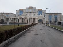
Avicenna Tajik State Medical University or ATSMU is a public university in Tajikistan. Established in 1939, it is located in Dushanbe and named after the Persian polymath Abuali Ibni Sino. It is managed by the Ministry of Health and is the only higher medical education facility in Tajikistan preparing medical personnel for the country.
Levakant, is a city in south-west Tajikistan. It is part of Khatlon Region, located just east of the regional capital Bokhtar and about 120 km south of the national capital Dushanbe. The Golovnaya Dam on the river Vakhsh lies directly to its east.
Abdurahmoni Jomi is a town in south-west Tajikistan. It is the administrative capital of Jomi District in Khatlon Region, located just north of the regional capital Qurghonteppa and about 100 km south of the national capital Dushanbe. Its population is 13,800. Both the town and the district were named after the Persian poet Jami.
The Ministry of Health and Social Protection is a government ministry that governs and manages healthcare and the health industry in Tajikistan, including the nation's public health system. The Ministry was founded in 2006 and is located in Dushanbe.
The 2019 Ligai Olii Tojikiston or 2019 Tajikistan Higher League was the 28th season of Ligai Olii Tojikiston, Tajikistan's top division of association football. The season will begin on 6 April 2019. and finished on 4 November 2019.
The COVID-19 pandemic in Tajikistan is part of the worldwide pandemic of coronavirus disease 2019 caused by severe acute respiratory syndrome coronavirus 2. The virus was confirmed to have spread to Tajikistan when its index cases, in Dushanbe and Khujand, were confirmed on 30 April 2020.