
Oceanus Procellarum is a vast lunar mare on the western edge of the near side of the Moon. It is the only one of the lunar maria to be called an "Oceanus" (ocean), due to its size: Oceanus Procellarum is the largest of the maria ("seas"), stretching more than 2,500 km (1,600 mi) across its north–south axis and covering roughly 4,000,000 km2 (1,500,000 sq mi), accounting for 10.5% of the total lunar surface area.

Mare Imbrium is a vast lava plain within the Imbrium Basin on the Moon and is one of the larger craters in the Solar System. The Imbrium Basin formed from the collision of a proto-planet during the Late Heavy Bombardment. Basaltic lava later flooded the giant crater to form the flat volcanic plain seen today. The basin's age has been estimated using uranium–lead dating methods to approximately 3.9 billion years ago, and the diameter of the impactor has been estimated to be 250 ± 25 km. The Moon's maria have fewer features than other areas of the Moon because molten lava pooled in the craters and formed a relatively smooth surface. Mare Imbrium is not as flat as it would have originally been when it first formed as a result of later events that have altered its surface.

Mare Humorum is a lunar mare. The impact basin it is located in is 425 kilometers (264 mi) across.
Mare Tranquillitatis is a lunar mare that sits within the Tranquillitatis basin on the Moon. It contains Tranquility Base, the first location on another celestial body to be visited by humans.

Mare Nubium is a lunar mare in the Nubium basin on the Moon's near side. The mare is located just to the southeast of Oceanus Procellarum.

The lunar maria are large, dark, basaltic plains on Earth's Moon, formed by lava flowing into ancient impact basins. They were dubbed maria by early astronomers who mistook them for actual seas. They are less reflective than the "highlands" as a result of their iron-rich composition, and hence appear dark to the naked eye. The maria cover about 16% of the lunar surface, mostly on the side visible from Earth. The few maria on the far side are much smaller, residing mostly in very large craters. The traditional nomenclature for the Moon also includes one oceanus (ocean), as well as features with the names lacus ('lake'), palus ('marsh'), and sinus ('bay'). The last three are smaller than maria, but have the same nature and characteristics.

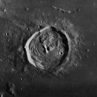
Archimedes is a large lunar impact crater on the eastern edges of the Mare Imbrium. Its diameter is 81 km.

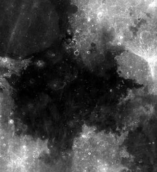
Eddington is the lava-flooded remnant of a lunar impact crater, located on the western part of Oceanus Procellarum. The western rim is attached to the wall of the walled plain Struve. To the east-southeast is the smaller but prominent crater Seleucus. South of Eddington is Krafft.

Kepler is a lunar impact crater that lies between the Oceanus Procellarum to the west and Mare Insularum in the east. To the southeast is the crater Encke. Kepler is named for the 17th century German astronomer and mathematician Johannes Kepler.

Lichtenberg is an isolated lunar impact crater located in the western part of the Oceanus Procellarum. The nearest crater of note is Briggs to the south.

Democritus is a lunar impact crater that is located on the northern part of the Moon, just to the north of the Mare Frigoris. Just to the south of Democritus is the lava-flooded crater Gärtner, which forms a bay on the mare. Directly to the north is Arnold, another flooded formation.
Briggs is a lunar impact crater that is located in the western part of the Oceanus Procellarum, to the east of the large walled plain Struve. It lies to the northeast of the walled plain Eddington, and north-northwest of the crater Seleucus. The isolated position of this crater on the mare, near the northwestern limb of the Moon, makes it relatively easy for an Earth-bound observer to locate. The crater is named after the English mathematician Henry Briggs.

Lyell is a lunar impact crater that lies along the eastern edge of the Mare Tranquillitatis, at the northern arm of the bay designated Sinus Concordiae. It was named after Scottish geologist Charles Lyell. To the north along the edge of the lunar mare is the crater Franz. The region of terrain to the east of Lyell is named Palus Somni.

Sinus Medii is a small lunar mare. It takes its name from its location at the intersection of the Moon's equator and prime meridian; as seen from the Earth, this feature is located in the central part of the Moon's near side, and it is the point closest to the Earth. From this spot, the Earth would always appear directly overhead, although the planet's position would vary slightly due to libration.

South is a large lunar impact crater that is located in the northwest part of the Moon. Most of the southern wall of this crater is joined to the Sinus Roris bay of the Oceanus Procellarum, with the southeast rim facing Mare Frigoris. Attached to the northwest of the formation is the larger walled plain Babbage. Just to the northeast is the crater Robinson, and farther to the northeast is another walled plain, J. Herschel.

Louville is a lunar impact crater that is located on the western edge of the Sinus Roris, a bay in the northern part of the Oceanus Procellarum. It lies to the northwest of the crater Mairan, on a triangular section of continental terrain to the west of Sinus Iridum and the Mare Imbrium.

Lacus Somniorum is a basaltic plain located in the northeastern part of the Moon's near side. It is located at selenographic coordinates 37.56° N, 30.8° E, and has a diameter of 424.76 kilometers. The name is Latin for Lake of Dreams, a title given to this feature by Giovanni Riccioli. It is the largest of the lunar features designated Lacus.

Sinus Roris is a dark, basaltic plain on the near side of the Moon that forms an extension of the northern edge of Oceanus Procellarum. The IAU-defined selenographic coordinates of this bay are 54.0° N, 56.6° W, and the diameter is 202 km.

Selenography is the study of the surface and physical features of the Moon. Like geography and areography, selenography is a subdiscipline within the field of planetary science. Historically, the principal concern of selenographists was the mapping and naming of the lunar terrane identifying maria, craters, mountain ranges, and other various features. This task was largely finished when high resolution images of the near and far sides of the Moon were obtained by orbiting spacecraft during the early space era. Nevertheless, some regions of the Moon remain poorly imaged and the exact locations of many features are uncertain by several kilometers. Today, selenography is considered to be a subdiscipline of selenology, which itself is most often referred to as simply "lunar science." The word selenography is derived from the Greek word Σελήνη and γράφω graphō, meaning to write.


