Planned/Future Mergers
| | This section is empty. You can help by adding to it. (March 2013) |
Here is a list of mergers in Ibaraki Prefecture, Japan since the Heisei era.
| | This section is empty. You can help by adding to it. (March 2013) |

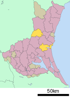
Ibaraki Prefecture is a prefecture of Japan located in the Kantō region of Honshu. Ibaraki Prefecture has a population of 2,871,199 and has a geographic area of 6,097.19 square kilometres. Ibaraki Prefecture borders Fukushima Prefecture to the north, Tochigi Prefecture to the northwest, Saitama Prefecture to the southwest, Chiba Prefecture to the south, and the Pacific Ocean to the east.

Hitachi Province was an old province of Japan in the area of Ibaraki Prefecture. It was sometimes called Jōshū (常州). Hitachi Province bordered on Shimōsa, Shimotsuke, and Mutsu Provinces. Generally, its northern border was with Mutsu.

Itako is a city located in Ibaraki Prefecture, Japan. As of 1 July 2020, the city had an estimated population of 27,577 in 10,849 households and a population density of 386 persons per km². The percentage of the population aged over 65 was 32.9%. The total area of the city is 71.40 square kilometres (27.57 sq mi). It is known for its annual iris festival. Much of the city is within the borders of the Suigo-Tsukuba Quasi-National Park.
Higashiibaraki District is a district located in Ibaraki Prefecture, Japan.
Nishiibaraki, literally West Ibaraki, was a district located in Ibaraki Prefecture, Japan.

Naka is a city located in Ibaraki Prefecture, Japan. As of 1 July 2020, the city had an estimated population of 53,153 in 20,953 households and a population density of 543.4 persons per km2. The percentage of the population aged over 65 was 32.4%. The total area of the city is 97.82 square kilometres (37.77 sq mi).
Kashima was a district located in Ibaraki Prefecture, Japan.
Hokota is a city located in Ibaraki Prefecture, Japan. As of 1 July 2020, the city had an estimated population of 45,997 in 18,455 households and a population density of 221.6 persons per km². The percentage of the population aged over 65 was 34.1%. The total area of the city is 207.60 square kilometres (80.15 sq mi).

Inashiki is a district located in Ibaraki Prefecture, Japan.
Niihari was a district located in Ibaraki, Japan. The district was dissolved on March 27, 2006.
Tsukuba was a district located in Ibaraki Prefecture, Japan.
Makabe was a district located in Ibaraki Prefecture, Japan.

Yūki is a district located in Ibaraki Prefecture, Japan. As at May, 2008, the district had an estimated Population of 23,388 and a Density of 396 persons/km2. The total area is 59.1 km2.

Kitasōma is a district located in Ibaraki Prefecture, Japan.

Katori is a city located in Chiba Prefecture, Japan. As of 1 November 2020, the city had an estimated population of 74,469 in 31,113 households and a population density of 280 persons per km2. The total area of the city is 262.31 square kilometres (101.28 sq mi). Katori Shrine is in the city of Katori, as is the old merchant town and canal of Sawara.

Namegata is a city located in Ibaraki Prefecture, Japan. As of 1 July 2020, the city had an estimated population of 32,144 in 11,412 households and a population density of 144.5 persons per km². The percentage of the population aged over 65 was 35.9%. The total area of the city is 222.48 square kilometres (85.90 sq mi).
| Core city | ||
|---|---|---|
| Special city | ||
| Cities | ||
| Districts | ||