Ibaraki Prefecture is a prefecture of Japan located in the Kantō region of Honshu. Ibaraki Prefecture has a population of 2,828,086 and has a geographic area of 6,097.19 square kilometres. Ibaraki Prefecture borders Fukushima Prefecture to the north, Tochigi Prefecture to the northwest, Saitama Prefecture to the southwest, Chiba Prefecture to the south, and the Pacific Ocean to the east.

Noshiro is a city located in Akita Prefecture, Japan. As of 28 February 2023, the city had an estimated population of 49,150 in 24,079 households, and a population density of 120 persons per km2. The total area of the city is 426.95 square kilometres (164.85 sq mi).

Ryūgasaki is a city located in Ibaraki Prefecture, Japan. As of 1 January 2024, the city had an estimated population of 75,212 in 33,421 households and a population density of 958 persons per km². The percentage of the population aged over 65 was 31.1% in July 2020. The total area of the city is 78.59 square kilometres (30.34 sq mi).

Takahagi is a city located in Ibaraki Prefecture, Japan. As of 1 July 2020, the city had an estimated population of 27,522 in 11,651 households and a population density of 140 persons per km2. The percentage of the population aged over 65 was 36.2%. The total area of the city is 193.58 square kilometres (74.74 sq mi).

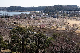
Kasama is a city located in Ibaraki Prefecture, Japan. Kasama is the home of Kasama ware and known for Japanese chestnuts. As of 1 July 2020, the city had an estimated population of 73,805 in 29,362 households and a population density of 307 persons per km². The percentage of the population aged over 65 was 32.2%. The total area of the city is 240.400 square kilometres (92.819 sq mi).

Tsuruga is a city located in Fukui Prefecture, Japan. As of 29 June 2018, the city had an estimated population of 66,123 in 28,604 households and the population density of 260 persons per km2. The total area of the city was 251.39 square kilometers (97.06 sq mi).

Takayama is a city located in Gifu Prefecture, Japan. As of 1 January 2019, the city had an estimated population of 88,473 in 35,644 households, and a population density of 41 persons per km2. The total area of the city was 2,177.61 square kilometers (840.78 sq mi) making it the largest city by area in Japan. The high altitude and separation from other areas of Japan kept the area fairly isolated, allowing Takayama to develop its own culture over about a 300-year period.
Tanabe is a city located in Wakayama Prefecture, Japan. As of 1 November 2021, the city had an estimated population of 70,972 in 35,076 households and a population density of 69 persons per km2. The total area of the city is 1,026.91 square kilometres (396.49 sq mi). Tanabe is the second most populous city in Wakayama, and the largest in the Kansai region of Japan in terms of area.

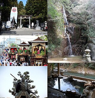
Kashima is a city located in Ibaraki Prefecture, Japan. As of 1 July 2020, the city had an estimated population of 67,197 in 28,873 households and a population density of 634 persons per km2. The percentage of the population aged over 65 was 31.5%. The total area of the city is 106.02 square kilometres (40.93 sq mi). Kashima is the home of the J. League's Kashima Antlers. Its home field, Kashima Soccer Stadium, was used as a site during the 2002 FIFA World Cup. The city is also the site of the Kashima Shrine, one of the oldest Shinto shrines in eastern Japan, and considered the birthplace of many influential styles of Japanese swordsmanship (Kenjutsu).
Hanawa is a town located in Fukushima Prefecture, Japan. As of 1 January 2020, the town had an estimated population of 8,369 in 3301 households, and a population density of 40 persons per km2. The total area of the town was 211.41 square kilometres (81.6 sq mi).
Semboku is a city located in Akita Prefecture, Japan. As of 31 January 2023, the city had an estimated population of 24,045 in 10,398 households, and a population density of 22 persons per km2. The total area of the city is 1,093.56 square kilometers (422 sq mi).
Uonuma is a city located in Niigata Prefecture, Japan. As of 1 July 2019, the city had an estimated population of 35,027 in 13,289 households, and a population density of 37 persons per km2. Its total area is 946.76 square kilometres (365.55 sq mi). The city is famous for its koshihikari rice, which commands a premium in the Japanese market.

Ainan is a town in Ehime Prefecture, Japan. As of 1 September 2022, the town had an estimated population of 19,733 in 10054 households, and a population density of 83 persons per km2. The total area of the town is 238.99 square kilometres (92.27 sq mi).

Iwaki is a city located in Fukushima Prefecture, Japan. As of 1 August 2023, Iwaki had a population of 322,019 in 143,500 households, and population density of 261 persons per km². The total area of the city is 1,232.02 square kilometres (475.69 sq mi), making it the largest city in the prefecture and the 10th largest city in Japan (2010) in terms of area. Iwaki is a designated core city, and is also one of the growing number of cities written in hiragana. The present Iwaki City started as the merger of 14 smaller municipalities on October 1, 1966. Every year, Iwaki hosts the Taira Tanabata Festival from 6–8 August.

Hitachi is a city located in Ibaraki Prefecture, Japan. As of 1 January 2024, the city had an estimated population of 165,822 in 76,702 households and a population density of 735 persons per km2. The percentage of the population aged over 65 was 32.7%. The total area of the city is 225.71 square kilometres (87.15 sq mi). Hitachi is well known in the world for its brand name of electric products, including power plants and appliances, of the Hitachi company founded in the town in 1910 by Namihei Odaira with considerable properties as its factories in the city.

Minami-Nakagō Station is a passenger railway station located in the city of Kitaibaraki, Ibaraki Prefecture, Japan, operated by the East Japan Railway Company.

Isohara Station is a passenger railway station in the city of Kitaibaraki, Ibaraki Prefecture, Japan, operated by East Japan Railway Company.

Ōtsukō Station is a passenger railway station located in the city of Kitaibaraki, Ibaraki Prefecture, Japan, operated by the East Japan Railway Company.
Hanakawa was a village located in Taga District, Ibaraki, Japan.

Rokkakudō (六角堂), was a hexagonal wooden retreat overlooking the sea along the Izura coast in Kitaibaraki, Ibaraki Prefecture, Japan. Dating to 1905, it was part of the Izura Institute of Arts & Culture, Ibaraki University. Constructed in the sukiya-zukuri style, single-storey, with a tiled roof, an area of nine square metres, and painted red, it was designed by scholar and critic Okakura Tenshin who spent time there with painter Yokoyama Taikan. In 2003 it was added to the Tangible Cultural Properties Register. On 11 March 2011 it was swept off to sea in the tsunami. It was rebuilt and opened to the public in April 2012.