Naka, Ibaraki

Last updated • 2 min readFrom Wikipedia, The Free Encyclopedia
Naka
那珂市
Naka city hall.jpg
Naka city hall
Flag of Naka, Ibaraki.svg
Emblem of Naka, Ibaraki.svg
Naka in Ibaraki Prefecture Ja.svg
Location of Naka in Ibaraki Prefecture
Japan location map with side map of the Ryukyu Islands.svg
Red pog.svg
Naka
 
Coordinates: 36°27′26.6″N140°29′12.3″E / 36.457389°N 140.486750°E / 36.457389; 140.486750
Country Japan
Region Kantō
Prefecture Ibaraki
Area
  Total
97.82 km2 (37.77 sq mi)
Population
 (September 1, 2020)
  Total
53,137
  Density540/km2 (1,400/sq mi)
Time zone UTC+9 (Japan Standard Time)
- Tree Sakura
- Flower Sunflower
- Bird Swan
Phone number029-298-1111
AddressFukuda 1819-5, Naka-shi, Ibaraki 311-0192
Website Official website

Naka (那珂市, Naka-shi) is a city located in Ibaraki Prefecture, Japan. As of 1 July 2020, the city had an estimated population of 53,153 in 20,953 households and a population density of 543.4 persons per km2. The percentage of the population aged over 65 was 32.4%. [1] The total area of the city is 97.82 square kilometres (37.77 sq mi).

Contents

Geography

Naka is located in north-central Ibaraki Prefecture, with the Naka River and Kuji River flowing through the city.

Surrounding municipalities

Ibaraki Prefecture

Demographics

Per Japanese census data, [2] the population of Naka peaked around the year 2000 and has declined slightly since.

Historical population
YearPop.±%
1920 38,559    
1930 37,829−1.9%
1940 37,718−0.3%
1950 38,427+1.9%
1960 37,544−2.3%
1970 38,256+1.9%
1980 44,768+17.0%
1990 51,078+14.1%
2000 55,069+7.8%
2010 54,240−1.5%
2020 53,502−1.4%

History

On March 31, 1955 the town of Sugaya and villages of Godai, Nakata, Kanzaki, Toda, Yoshino and Kizaki were merged to become the town of Naka (within Naka District). The town was the 4th largest population within the prefecture, following the town of Kamisu (from Kashima District), the town of Sōwa (from Sashima District), and the town of Ami (from Inashiki District).

On January 21, 2005 Naka absorbed the town of Urizura (from Naka District) to become the city of Naka.

Government

Naka has a mayor-council form of government with a directly elected mayor and a unicameral city council of 18 members. Naka contributes one member to the Ibaraki Prefectural Assembly. In terms of national politics, the city is part of Ibaraki 4th district of the lower house of the Diet of Japan.

Economy

Kiuchi Brewery (木内酒造) is a brewery in Naka. It was established in 1823 as a sake and Shōchū producer.

Renesas Electronics has a 300mm fab in Naka, Ibaraki prefecture. This semiconductor factory makes chips for the automotive manufacturing industry. [3]

Education

Naka has nine public elementary schools and five public middle schools operated by the city government, and two public high schools operated by the Ibaraki Prefectural Board of Education. The Ibaraki Women's Junior College is also located in Naka.

Transportation

Railway

JR logo (east).svg JR EastSuigun Line

JR logo (east).svg JR EastSuigun Line - Hitachi-Ōta Branch

Highway

Sister and friendly cities

Local attractions

Related Research Articles

<span class="mw-page-title-main">Ibaraki Prefecture</span> Prefecture of Japan

Ibaraki Prefecture is a prefecture of Japan located in the Kantō region of Honshu. Ibaraki Prefecture has a population of 2,828,086 and has a geographic area of 6,097.19 square kilometres. Ibaraki Prefecture borders Fukushima Prefecture to the north, Tochigi Prefecture to the northwest, Saitama Prefecture to the southwest, Chiba Prefecture to the south, and the Pacific Ocean to the east.

<span class="mw-page-title-main">Hitachiōta, Ibaraki</span> City in Kantō, Japan

Hitachiōta is a city located in Ibaraki Prefecture, Japan. As of 1 July 2020, the city had an estimated population of 48,074 in 19,327 households and a population density of 129.2 persons per km2.. The percentage of the population aged over 65 was 36.2%. The total area of the city is 371.99 square kilometres (143.63 sq mi).

<span class="mw-page-title-main">Hitachinaka, Ibaraki</span> City in Kantō, Japan

Hitachinaka is a city located in Ibaraki Prefecture, Japan. As of 1 July 2020, the city had an estimated population of 154,663 in 64,900 households and a population density of 1547 persons per km2. The percentage of the population aged over 65 was 26.1%. The total area of the city is 99.96 square kilometres (38.59 sq mi). It is a "hiragana city", the place name is written with the hiragana syllabary and not the traditional kanji.

<span class="mw-page-title-main">Hitachiōmiya</span> City in Kantō, Japan

Hitachiōmiya is a city located in Ibaraki Prefecture, Japan. As of 1 July 2020, the city had an estimated population of 39,281 in 16.047 households and a population density of 220 persons per km2. The percentage of the population aged over 65 was 37.6%. The total area of the city is 348.45 square kilometres (134.54 sq mi).

<span class="mw-page-title-main">Daigo, Ibaraki</span> Town in Kantō, Japan

Daigo is a town located in Ibaraki Prefecture, Japan. As of 1 July 2020, the town had an estimated population of 15,771 in 6431 households and a population density of 48.4 inhabitants per square kilometre (125/sq mi). The percentage of the population aged over 65 was 46.6%. The total area of the town is 325.76 square kilometres (125.78 sq mi).

<span class="mw-page-title-main">Mito, Ibaraki</span> Core city in Kantō, Japan

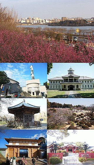
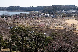
Mito is the capital city of Ibaraki Prefecture, in the northern Kantō region of Japan. As of 1 January 2024, the city had an estimated population of 268,036 in 126,055 households and a population density of 1,233 persons per km2. The percentage of the population aged over 65 was 27.1%. The total area of the city is 217.32 square kilometres (83.91 sq mi).

<span class="mw-page-title-main">Hitachi, Ibaraki</span> City in Kantō, Japan

Hitachi is a city located in Ibaraki Prefecture, Japan. As of 1 January 2024, the city had an estimated population of 165,822 in 76,702 households and a population density of 735 persons per km2. The percentage of the population aged over 65 was 32.7%. The total area of the city is 225.71 square kilometres (87.15 sq mi). Hitachi is well known in the world for its brand name of electric products, including power plants and appliances, of the Hitachi company founded in the town in 1910 by Namihei Odaira with considerable properties as its factories in the city.

<span class="mw-page-title-main">Suigun Line</span>

The Suigun Line is a Japanese railway line operated by East Japan Railway Company, which connects Mito Station in Ibaraki Prefecture and Asaka-Nagamori Station in Fukushima Prefecture, Japan. All trains on the line continue onto the Tōhoku Main Line to Kōriyama Station. The name of the line includes one kanji from each of the terminals, Mito () and Kōriyama ().

<span class="mw-page-title-main">Godai Station</span> Railway station in Naka, Ibaraki Prefecture, Japan

Godai Station is a passenger railway station in the city of Naka, Ibaraki, Japan operated by East Japan Railway Company.

<span class="mw-page-title-main">Shimo-Sugaya Station</span> Railway station in Naka, Ibaraki Prefecture, Japan

Shimo-Sugaya Station is a passenger railway station in the city of Naka, Ibaraki, Japan operated by East Japan Railway Company.

<span class="mw-page-title-main">Naka-Sugaya Station</span> Railway station in Naka, Ibaraki Prefecture, Japan

Naka-Sugaya Station is a passenger railway station in the city of Naka, Ibaraki, Japan operated by East Japan Railway Company.

<span class="mw-page-title-main">Kami-Sugaya Station</span> Railway station in Naka, Ibaraki Prefecture, Japan

Kami-Sugaya Station is a junction passenger railway station in the city of Naka, Ibaraki, Japan operated by East Japan Railway Company.

<span class="mw-page-title-main">Hitachi-Kōnosu Station</span> Railway station in Naka, Ibaraki Prefecture, Japan

Hitachi-Kōnosu Station is a passenger railway station in the city of Naka, Ibaraki, Japan operated by East Japan Railway Company.

<span class="mw-page-title-main">Urizura Station</span> Railway station in Naka, Ibaraki Prefecture, Japan

Urizura Station is a passenger railway station in the city of Naka, Ibaraki, Japan operated by East Japan Railway Company.

<span class="mw-page-title-main">Shizu Station (Ibaraki)</span> Railway station in Naka, Ibaraki Prefecture, Japan

Shizu Station is a passenger railway station in the city of Naka, Ibaraki, Japan operated by East Japan Railway Company.

<span class="mw-page-title-main">Minami-Sakaide Station</span>

Minami-Sakaide Station is a passenger railway station in the city of Naka, Ibaraki Prefecture, operated by East Japan Railway Company.

<span class="mw-page-title-main">Nukada Station</span>

Nukada Station is a passenger railway station in the city of Naka, Ibaraki, Japan operated by East Japan Railway Company.

<span class="mw-page-title-main">Kawai Station (Ibaraki)</span>

Kawai Station is a passenger railway station in the city of Hitachiōta, Ibaraki Prefecture, operated by East Japan Railway Company.

<span class="mw-page-title-main">Yagawara Station</span>

Yagawara Station is a passenger railway station in the city of Hitachiōta, Ibaraki Prefecture, operated by East Japan Railway Company.

<span class="mw-page-title-main">Hitachi-Ōta Station</span>

Hitachi-Ōta Station is a passenger railway station in the city of Hitachiōta, Ibaraki Prefecture, operated by East Japan Railway Company.

References

  1. "Ibaraki prefectural official statistics" (in Japanese). Japan.
  2. Naka population statistics
  3. "Renesas aims for full return of fire-hit chip plant by July". 19 April 2021.
  4. "Oak Ridge, Tennessee Sister City Partners". Oak Ridge Tennessee Sister Cities Support Organization. 2015. Retrieved 13 December 2015.
  5. "広報なか271号" (PDF) (in Japanese). Retrieved 2024-06-11.