The United States contains a number of mountain ranges named Antelope (or similar):
This set index article includes a list of mountains that share the same name (or similar names).
The United States contains a number of mountain ranges named Antelope (or similar):

Oolong is a traditional semi-oxidized Chinese tea produced through a process including withering the plant under strong sun and oxidation before curling and twisting. Most oolong teas, especially those of fine quality, involve unique tea plant cultivars that are exclusively used for particular varieties. The degree of oxidation, which varies according to the chosen duration of time before firing, can range from 8 to 85%, depending on the variety and production style. Oolong is especially popular in south China and among ethnic Chinese in Southeast Asia as is the Fujian preparation process known as the Gongfu tea ceremony.
Mountain Dew, stylized as Mtn Dew, is a carbonated soft drink brand produced and owned by PepsiCo. The original formula was invented in 1940 by Tennessee beverage bottlers Barney and Ally Hartman. A revised formula was created by Bill Bridgforth in 1958. The rights to this formula were obtained by the Tip Corporation of Marion, Virginia. William H. "Bill" Jones of the Tip Corporation further refined the formula, launching that version of Mountain Dew in 1961. In August 1964, the Mountain Dew brand and production rights were acquired from Tip by the Pepsi-Cola company, and the distribution expanded across the United States and Canada.

Mountain guns are artillery pieces designed for use in mountain warfare and areas where usual wheeled transport is not possible. They are generally capable of being taken apart to make smaller loads for transport by horses, humans, mules, tractors, or trucks. As such, they are sometimes called "pack guns" or "pack howitzers". During the American Civil War these small portable guns were widely used and were called "mountain howitzers".

The St. Francois Mountains in southeast Missouri are a mountain range of Precambrian igneous mountains rising over the Ozark Plateau. This range is one of the oldest exposures of igneous rock in North America. The name of the range is spelled out as Saint Francois Mountains in official GNIS sources, but it is sometimes misspelled in use as St. Francis Mountains to match the anglicized pronunciation of both the range and St. Francois County.

A mountain pass is a navigable route through a mountain range or over a ridge. Since many of the world's mountain ranges have presented formidable barriers to travel, passes have played a key role in trade, war, and both human and animal migration throughout history. At lower elevations it may be called a hill pass. A mountain pass is typically formed between two volcanic peaks or created by erosion from water or wind.

A hulder is a seductive forest creature found in Scandinavian folklore. Her name derives from a root meaning "covered" or "secret". In Norwegian folklore, she is known as huldra. She is known as the skogsrå "forest spirit" or Tallemaja "pine tree Mary" in Swedish folklore, and ulda in Sámi folklore. Her name suggests that she is originally the same being as the völva divine figure Huld and the German Holda.

Rocky Mountain oysters or mountain oysters, or meat balls, also known as prairie oysters in Canada, is a dish made of bull testicles. The organs are often deep-fried after being skinned, coated in flour, pepper and salt, and sometimes pounded flat. This delicacy is most often served as an appetizer.
Mount Clemenceau is the fourth highest mountain in the Park Ranges of the Canadian Rockies. The peak was originally named "Pyramid" in 1892 by Arthur Coleman. The mountain was renamed by the Interprovincial Boundary Survey in 1919 to its present name, which is for Georges Clemenceau, premier of France during World War I.

Cycle sport is competitive physical activity using bicycles. There are several categories of bicycle racing including road bicycle racing, cyclo-cross, mountain bike racing, track cycling, BMX, and cycle speedway. Non-racing cycling sports include artistic cycling, cycle polo, freestyle BMX and mountain bike trials. The Union Cycliste Internationale (UCI) is the world governing body for cycling and international competitive cycling events. The International Human Powered Vehicle Association is the governing body for human-powered vehicles that imposes far fewer restrictions on their design than does the UCI. The UltraMarathon Cycling Association is the governing body for many ultra-distance cycling races.
Mountains named Granite Peak or variations.

The Taconic Mountains or Taconic Range are a range of the Appalachian Mountains, running along the eastern border of New York State and adjacent New England from northwest Connecticut to western Massachusetts, north to central western Vermont. A physiographic region of the larger New England province, the range includes notable summits, including its high point, 3,840 feet (1,170 m) Mount Equinox in Vermont, and 3,489 feet (1,063 m) Mount Greylock, the highest point in Massachusetts.

Mount Darwin is a flat-topped mountain in the Sierra Nevada, on the border of between Fresno and Inyo counties in Kings Canyon National Park and the John Muir Wilderness of California.
Mount Queen Bess is one of the principal summits of the Pacific Ranges of the Coast Mountains of southern British Columbia. It stands west of Chilko Lake and to the south of Tatlayoko Lake, and crowns a peak-studded ridge to the north of the Homathko Icefield.
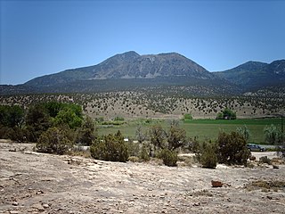
Ute Mountain, also known as Ute Peak or Sleeping Ute Mountain, is a peak within the Ute Mountains, a small mountain range in the southwestern corner of Colorado. It is on the northern edge of the Ute Mountain Ute Tribe Reservation. The Reservation forms the southwestern corner of the state and of Montezuma County.
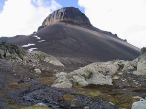
Little Ring Mountain, also called Little Ring Peak, is a tuya in the Pacific Ranges of the Coast Mountains in southwestern British Columbia, Canada. It lies at the head of the Squamish and Soo Rivers. Part of the Mount Cayley volcanic field, its most recent eruption most likely occurred during the Fraser Glaciation.
The Red Tusk is a mountain in the Tantalus Range of the Pacific Ranges in southwestern British Columbia, Canada, located 5 km (3.1 mi) southeast of Mount Tantalus and 11 km (6.8 mi) west of Cheekye.

The Tartarus Montes are a mountain range on the planet Mars, stretching over 1070 km and located around the coordinates 15.46º N, 167.54º E, between Orcus Patera and the Elysium volcanic region.