List of parks and open spaces in Derbyshire

Last updated

This is a partial list of parks and open spaces in the county of Derbyshire in England. It includes urban parks, country parks, woodlands, commons, lakes, local nature reserves and other green spaces that are open to the public.

Contents

Parks and open spaces in Derbyshire

NameImageLocationTypeNotesRefs
Alfreton Park Alfreton Park 1 - geograph.org.uk - 1480197.jpg Alfreton Urban park
Allestree Park Allestree Hall in Allestree Park in Derby - geograph.org.uk - 1653016.jpg Derby Urban parkLargest city park in Derby. 18th century origins. Largest Local Nature Reserve in Derbyshire. [1]
Alvaston Park Alvaston Park, Derby - geograph.org.uk - 6383.jpg Derby Urban parkRiverside park of 85 acres, opened in 1913. [2]
Ashbourne Recreation Ground Ashbourne Urban park [3]
Ashwood Park AshwoodPark.jpg Buxton Urban parkThe public park runs along the side of the River Wye and has a bowling green, two public tennis courts, a children's playground and a multi-use games area. The park was laid out in the 1920s. [4]
Aston-on-Trent Brickyard Plantation Aston-on-Trent Woodland [5]
Bakewell Recreation Ground Bakewell Urban park
Bankswood Park Glossop Urban parkIn Hadfield district [6]
Bath Gardens Bakewell Gardens [7]
Belper Parks Belper Urban park and nature reserveOriginally part of the medieval Royal Forest of Duffield Frith [8]
Belper River Gardens Belper North Mill and River Gardens - geograph.org.uk - 18617.jpg Belper Urban park [9]
Bluebell Wood Hayfield Nature reserve [10]
Buxton Country Park and Grin Woods Solomon's Temple, Buxton - geograph.org.uk - 14811.jpg Buxton Country park and woodlandBuxton Country Park is operated by Buxton Civic Association and the park has 100 acres of mature woodland, with a network of woodland trails including a path leading to Solomon's Temple at the summit of Grin Low hill. The country park has a 'Go Ape!' tree-top adventure course with zip wires. In 1820 the 6th Duke of Devonshire commissioned the 'Grin Plantation' to shield the scarred lime-burning landscape from visitors to the spa town. [11]
Calke Abbey Calke Abbey 02.jpg Ticknall Park and formal gardens National Trust estate and deer park. One of four National Nature Reserves in Derbyshire, covering 79.7 hectares (197 acres). [12]
Carsington Water Walking Trail around Carsington Water in 2019.jpg Ashbourne Country parkWalking and cycling trails around the reservoir [13]
Chaddesden ParkDerbyUrban park [14]
Chatsworth Estate Chatsworth Bridge.jpg Bakewell Park and formal gardens1000 acres of parkland by the River Derwent designed by Lancelot 'Capability' Brown in the 1760s. 105 acres of gardens. [15]
Corbar Woods Bluebells in Corbar Woods.jpg BuxtonWoodland8.7 hectares (21 acres) on Corbar Hill managed by Buxton Civic Association. [16]
Cote Heath Park Buxton Urban parkThe public park has a football pitch, a bowling green, a skate park, a multi-use games area and a children's playground [17]
Cotes Park and Pennytown Plantations Pennytown ponds somercotes.jpg Alfreton Woodland [18]
Cray's Hill Queen Elizabeth Park Swanwick Urban park [19]
Crossley Park Ripley Urban parkCrossley family donated it to Ripley town in 1901 [20]
Darley Park Darley Park, looking north-eastwards.jpg Derby Urban parkOpened in 1931 [21]
Derby Arboretum The fountain in the Derby Arboretum - geograph.org.uk - 1101279.jpg Derby Urban parkGrade II* listed historic park, opened in 1840 [22]
Derwent Gardens Matlock Bath Urban park [23]
Elvaston Castle Elvaston Castle - geograph.org.uk - 6308.jpg Elvaston Country parkOperated by Derbyshire County Council with public access since 1970. 321 acres of parkland, woodland and formal gardens. [24]
Eureka Park Eureka^ - geograph.org.uk - 288986.jpg Swadlincote Urban parkRecreation ground since the 1920s [25]
Frith Wood Dronfield Woodland [26]
Gadley Woods Stepping Stones in Gadley Woods, Buxton.jpg Buxton Woodland2.8 hectares (6.9 acres) managed by Buxton Civic Association. [16]
Hall Leys Park Hall Leys Park in Matlock town - geograph.org.uk - 1088856.jpg Matlock Urban Park [27]
Hardwick Hall Visitors' drive to Hardwick Hall - geograph.org.uk - 804652.jpg Chesterfield Park and formal gardensNational Trust estate [28]
Heanor Memorial Park Heanor Urban parkOpened in 1951 [29]
Heights of Abraham Victoria Prospect Tower, Heights of Abraham (geograph 6126594).jpg Matlock Bath Urban parkGrade II* listed historic hilltop park with two large caverns. Privately run with admission charge. [30]
Hogshaw Woods Buxton 1.1 hectares (2.7 acres) managed by Buxton Civic Association. [16]
Holmewood Woodlands Holmewood Woodland [31]
Howard Park Victorian Baths, Howard Park, Glossop - geograph.org.uk - 32992.jpg Glossop Urban park [32]
Kedleston Hall Kedleston Hall 20080730-01.jpg Derby Park and formal gardensNational Trust estate with 800 acres of parkland [33]
Lovers' Walks Matlock Bath Urban parkDates back to the 1740s [34]
Manners Plantations Ilkeston Woodland [35]
Manor Park Manor Park glossop 1.jpg Glossop Urban park [36]
Markeaton Park Markeaton Bridge, Markeaton Park, Derby - geograph.org.uk - 1652976.jpg Derby Urban park207 acres, opened in 1931. [37]
Maurice Lea Memorial Park Maurice Lea Memorial Park - geograph.org.uk - 1308867.jpg Swadlincote Urban parkGifted to the town by Herbert Lea, in memory of his son Maurice who was killed in World War I. It was created in 1930 and was restored in 2005. [38]
Memorial Park Pump track facility in Whaley Bridge Memorial Park.jpg Whaley Bridge Urban park [39]
Newhall Park Swadlincote Urban park [40]
Normanton Park Normanton Park, Derby - geograph.org.uk - 52385.jpg DerbyUrban parkOpened in 1909. [41]
Pavilion Gardens Benkid77 Pavilion Gardens lake 1 080809.JPG Buxton Urban parkThe 23-acre site is a Grade II* listed historic park, landscaped in 1871 by Edward Milner and earlier by Joseph Paxton. Two tributaries of the River Wye run through is with ornamental cascades. The park has a boating lake, 2 other lakes, playgrounds, a miniature railway, a bandstand and a cafe in the Victorian pavilion. There is also a swimming pool and car park. [42]
Peak District Mam Tor Castleton.jpg High Peak and Derbyshire Dales National parkEstablished in 1951 as the UK's first national park, covering hundreds of square miles of gritstone moorlands and ridges and limestone hills and dales. [43]
Poolsbrook Country Park Poolsbrook Country Park - geograph.org.uk - 891819.jpg Chesterfield Country Park165 acres of woodland, meadows, lakes and wildlife habitats. [44]
Queen's Park Queens Park in Chesterfield with the Boating Lake in View - geograph.org.uk - 1612.jpg Chesterfield Urban parkGrade II* listed historic park, opened in 1887. [45]
Riddings Wood Leaving Riddings Park at Somercotes - geograph.org.uk - 1448053.jpg Riddings Woodland [46]
Serpentine Walks Serpentine Walks in Buxton.jpg Buxton Urban parkGrade II* listed historic park alongside the River Wye, landscaped in the 1830s by Joseph Paxton. [42]
Shaw Wood Oakerthorpe Woodland [47]
Sherbrook Wood Sherbrook Wood.jpg Buxton Woodland3 acres of woodland managed by the Buxton Civic Association and the southern section is owned by Derbyshire County Council. [16]
Shipley Country Park Osbornes Pond, Shipley Park (geograph 5469049).jpg Shipley Country parkOperated by Derbyshire County Council with public access since 1976. 700 acres of parkland and woodland. [48]
Sinfin Moor Park and Nature Reserve Derby Urban park [49]
Sleet Moor Wood and Colliery Plantation Swanwick Woodland [50]
Somercotes Park Somercotes Urban park [51]
The Slopes The Slopes, Buxton.jpg Buxton Urban parkGrade II listed public park, laid out by landscape architect Jeffry Wyatville in 1811 opposite The Crescent. The town's war memorial and weather station are location on The Slopes. [52]
Victoria Park Ilkeston Urban park [53]
West Park Flowerbed in West Park, Long Eaton - geograph.org.uk - 923166.jpg Long Eaton Urban park [54]

See also

Related Research Articles

<span class="mw-page-title-main">Peak District</span> Upland area in England

The Peak District is an upland area in England, at the southern end of the Pennines. Mostly in Derbyshire, it extends into Cheshire, Greater Manchester, Staffordshire, West Yorkshire and South Yorkshire. It is subdivided into the Dark Peak, moorland dominated by gritstone, and the White Peak, a limestone area with valleys and gorges. The Dark Peak forms an arc on the north, east and west of the district, and the White Peak covers central and southern areas. The highest point is Kinder Scout. Most of the area is within the Peak District National Park, a protected landscape designated in 1951.

<span class="mw-page-title-main">Derbyshire</span> County of England

Derbyshire is a ceremonial county in the East Midlands of England. It borders Greater Manchester, West Yorkshire, and South Yorkshire to the north, Nottinghamshire to the east, Leicestershire to the south-east, Staffordshire to the south and west, and Cheshire to the west. Derby is the largest settlement, and Matlock is the county town.

<span class="mw-page-title-main">Bakewell</span> Market town in Derbyshire, England

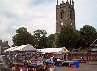
Bakewell is a market town and civil parish in the Derbyshire Dales district of Derbyshire, England, known for Bakewell pudding. It lies on the River Wye, 13 miles (21 km) south-west of Sheffield. At the 2011 census, the population of the civil parish was 3,949. It was estimated at 3,695 in 2019. The town is close to the tourist attractions of Chatsworth House and Haddon Hall.

<span class="mw-page-title-main">Matlock, Derbyshire</span> County town of Derbyshire

Matlock is the county town of Derbyshire, England. It is in the south-eastern part of the Peak District, with the National Park directly to the west. The spa resort of Matlock Bath is immediately south of the town as well as Cromford lying further south still. The civil parish of Matlock Town had a population in the 2021 UK census of 10,000.

<span class="mw-page-title-main">Matlock Bath</span> Human settlement in England

Matlock Bath is a village and civil parish in Derbyshire, England. It lies in the Derbyshire Dales, south of Matlock on the main A6 road, and approximately halfway between Buxton and Derby. The population of the civil parish at the 2011 census was 753. Originally built at the head of a dead-end dirt road running along the valley of the River Derwent from Matlock, the settlement developed in the 19th century as residential and a spa town which remains a tourist destination. The steep hillside restricts development with most buildings on one side of the valley and only footbridges across the river. The road was upgraded, becoming a through-way, now designated A6, avoiding the previous coaching road approach to Matlock from Cromford over very steep hills near to the Riber plateau area.

<span class="mw-page-title-main">High Peak, Derbyshire</span> Local government district in Derbyshire, England

High Peak is a local government district with borough status in Derbyshire, England, covering a high moorland plateau in the Dark Peak area of the Peak District National Park. The district stretches from Holme Moss in the north to Sterndale Moor in the south, and from Hague Bar in the west to Bamford in the east. The population of the borough taken at the 2011 Census was 90,892. The borough is unusual in having two administrative centres for its council, High Peak Borough Council; the offices are in Buxton and Glossop. Other towns include Chapel-en-le-Frith, Hadfield, New Mills and Whaley Bridge.

<span class="mw-page-title-main">Derbyshire Dales</span> Non-metropolitan district in England

Derbyshire Dales is a local government district in Derbyshire, England. The district was created in 1974 as West Derbyshire; the name was changed to Derbyshire Dales in 1987. The council is based in the town of Matlock, and the district also includes the towns of Ashbourne, Bakewell, Darley Dale and Wirksworth, as well as numerous villages and extensive rural areas. Much of the district is within the Peak District National Park.

<span class="mw-page-title-main">Borough of Erewash</span> Borough in eastern Derbyshire, England

Erewash is a local government district with borough status in Derbyshire, England. The borough is named after the River Erewash. The council has offices in both the borough's towns of Ilkeston and Long Eaton. The borough also includes several villages and surrounding rural areas. Some of the built-up areas in the east of the borough form part of the Nottingham Urban Area.

<span class="mw-page-title-main">History of Derbyshire</span> History of the county of Derbyshire in England

The history of Derbyshire can be traced back to human settlement since the last Ice Age, over 10,000 years ago. The county of Derbyshire in England dates back to the 11th century.

<span class="mw-page-title-main">Manchester, Buxton, Matlock and Midland Junction Railway</span> Railway in England

The Manchester, Buxton, Matlock and Midland Junction Railway ran from a junction with the Midland Railway at Ambergate to Rowsley north of Matlock and thence to Buxton.

<span class="mw-page-title-main">Derbyshire County Council</span>

Derbyshire County Council is the upper-tier local authority for the non-metropolitan county of Derbyshire in England. The council is based at County Hall in Matlock. Since 2017 the council has been under Conservative majority control.

The Monsal Trail is a cycling, horse riding and walking trail in the Derbyshire Peak District. It was constructed from a section of the former Manchester, Buxton, Matlock and Midland Junction Railway, which was built by the Midland Railway in 1863 to link Manchester with London and closed in 1968. The Monsal Trail is about 8.5 miles (13.7 km) long and opened in 1981. It starts at the Topley Pike junction in Wye Dale, 3 miles (4.8 km) east of Buxton, and runs to Coombs Viaduct, 1 mile (1.6 km) south-east of Bakewell. It follows the valley of the River Wye. The trail passes through Blackwell Mill, Chee Dale, Millers Dale, Cressbrook, Monsal Dale, Great Longstone, Hassop and Bakewell. The trail has numerous landmarks including Headstone Viaduct, Cressbrook Mill, Litton Mill and Hassop railway station, and passes through six tunnels.

<span class="mw-page-title-main">Derwent Valley Heritage Way</span> Long distance footpath in England

The Derwent Valley Heritage Way (DVHW) is a 55 miles (89 km) waymarked footpath along the Derwent Valley through the Peak District. The walk starts from Ladybower Reservoir in the Peak District National Park via Chatsworth, the scenery around the Derbyshire Dales, and through the Derwent Valley Mills World Heritage Site. It follows the Riverside Path through Derby and continues onwards to the historic inland port of Shardlow. Journey's end is at Derwent Mouth where the River Derwent flows into the River Trent.

<span class="mw-page-title-main">Grade II* listed buildings in Derbyshire</span>

The county of Derbyshire is divided into nine districts. The districts of Derbyshire are High Peak, Derbyshire Dales, South Derbyshire, Erewash, Amber Valley, North East Derbyshire, Chesterfield, Bolsover, and Derby.

<span class="mw-page-title-main">Northwood and Tinkersley</span> Civil parish in Derbyshire, England

Northwood and Tinkersley is a civil parish within the Derbyshire Dales district, in the county of Derbyshire, England. Named for its main settlements, with a mix of rural and built up areas, it had a population of 665 residents in 2011. The parish is 126 miles (203 km) north west of London, 18 miles (29 km) north west of the county city of Derby, and 3+12 miles (5.6 km) north west of the nearest market town of Matlock. Northwood and Tinkersley is directly adjacent to the Peak District national park to the west, and shares a border with the parishes of Darley Dale, Rowsley and Stanton.

References

  1. "Allestree Park". Discover Derby. Retrieved 12 November 2020.
  2. "Alvaston Park". Discover Derby. Retrieved 12 November 2020.
  3. Council, Derbyshire Dales District. "Ashbourne Recreation Ground". Derbyshire Dales District Council. Retrieved 12 November 2020.
  4. "Ashwood Park, Buxton". High Peak Borough Council. Retrieved 12 November 2020.
  5. "Aston on Trent Brickyard Plantation - Derbyshire County Council". www.derbyshire.gov.uk. Retrieved 12 November 2020.
  6. "Bankswood Park, Hadfield". High Peak Borough Council. Retrieved 12 November 2020.
  7. Council, Derbyshire Dales District. "Bath Gardens, Bakewell". Derbyshire Dales District Council. Retrieved 12 November 2020.
  8. Council, Amber Valley Borough (18 June 2020). "Belper Parks Local Nature Reserve". www.ambervalley.gov.uk. Retrieved 12 November 2020.
  9. Council, Amber Valley Borough (18 June 2020). "Belper River Gardens". www.ambervalley.gov.uk. Retrieved 12 November 2020.
  10. "Bluebell Wood Local Nature Reserve - Derbyshire County Council". www.derbyshire.gov.uk. Retrieved 12 November 2020.
  11. "Buxton Country Park & Woodland Walks | Visit Buxton" . Retrieved 12 November 2020.
  12. "Calke Abbey". National Trust. Retrieved 12 November 2020.
  13. "Carsington Water | Come visit us | Experience water | Wonderful on Tap | Severn Trent Water". www.stwater.co.uk. Retrieved 12 November 2020.
  14. "Chaddesden Park". Discover Derby. Retrieved 12 November 2020.
  15. "Park & estate". www.chatsworth.org. Retrieved 12 November 2020.
  16. 1 2 3 4 "Woodlands". Buxton Civic Association. Retrieved 12 November 2020.
  17. "Cote Heath Park, Buxton". High Peak Borough Council. Retrieved 12 November 2020.
  18. "Cotes Park and Pennytown Plantations - Derbyshire County Council". www.derbyshire.gov.uk. Retrieved 12 November 2020.
  19. Council, Amber Valley Borough (18 June 2020). "Cray's Hill". www.ambervalley.gov.uk. Retrieved 12 November 2020.
  20. Council, Amber Valley Borough (18 June 2020). "Crossley Park". www.ambervalley.gov.uk. Retrieved 12 November 2020.
  21. "Darley Park". Discover Derby. Retrieved 12 November 2020.
  22. Historic England. "Derby Arboretum (1000677)". National Heritage List for England . Retrieved 12 November 2020.
  23. Council, Derbyshire Dales District. "Derwent Gardens, Matlock Bath". Derbyshire Dales District Council. Retrieved 12 November 2020.
  24. "Elvaston Castle Country Park - Derbyshire County Council". www.derbyshire.gov.uk. Retrieved 12 November 2020.
  25. "Eureka Park". South Derbyshire District Council. Retrieved 12 November 2020.
  26. "Frith Wood - Derbyshire County Council". www.derbyshire.gov.uk. Retrieved 12 November 2020.
  27. Council, Derbyshire Dales District. "Hall Leys Park, Matlock". Derbyshire Dales District Council. Retrieved 12 November 2020.
  28. "Hardwick". National Trust. Retrieved 12 November 2020.
  29. Council, Amber Valley Borough (18 June 2020). "Heanor Memorial Park". www.ambervalley.gov.uk. Retrieved 12 November 2020.
  30. "Heights of Abraham, Matlock Bath". Historic England. Archived from the original on 10 August 2017. Retrieved 9 August 2017.
  31. "Holmewood Woodlands - Derbyshire County Council". www.derbyshire.gov.uk. Retrieved 12 November 2020.
  32. "Howard Park, Glossop". High Peak Borough Council. Retrieved 12 November 2020.
  33. "Kedleston Hall". Discover Derby. Retrieved 12 November 2020.
  34. Council, Derbyshire Dales District. "Lovers' Walks, Matlock Bath". Derbyshire Dales District Council. Retrieved 12 November 2020.
  35. "Manners Plantations - Derbyshire County Council". www.derbyshire.gov.uk. Retrieved 12 November 2020.
  36. "Manor Park, Glossop". High Peak Borough Council. Retrieved 12 November 2020.
  37. "Markeaton Park". Discover Derby. Retrieved 12 November 2020.
  38. "Maurice Lea Memorial Park". South Derbyshire District Council. Retrieved 12 November 2020.
  39. "Memorial Park, Whaley Bridge". High Peak Borough Council. Retrieved 12 November 2020.
  40. "Newhall Park". South Derbyshire District Council. Retrieved 12 November 2020.
  41. "Normanton Park". Discover Derby. Retrieved 12 November 2020.
  42. 1 2 Historic England. "Pavilion Gardens, Buxton (Grade II*) (1000675)". National Heritage List for England. Retrieved 21 January 2020.
  43. "Home". Peak District National Park. Retrieved 12 November 2020.
  44. "Poolsbrook Country Park". www.chesterfield.gov.uk. 12 March 2020. Retrieved 12 November 2020.
  45. Historic England. "Queen's Park (1001482)". National Heritage List for England . Retrieved 12 November 2020.
  46. "Riddings Wood - Derbyshire County Council". www.derbyshire.gov.uk. Retrieved 12 November 2020.
  47. "Shaw Wood - Derbyshire County Council". www.derbyshire.gov.uk. Retrieved 12 November 2020.
  48. "Shipley Country Park - Derbyshire County Council". www.derbyshire.gov.uk. Retrieved 12 November 2020.
  49. "Sinfin Moor Park and Nature Reserve". Discover Derby. Retrieved 12 November 2020.
  50. "Sleet Moor Wood and Colliery Plantation - Derbyshire County Council". www.derbyshire.gov.uk. Retrieved 12 November 2020.
  51. Council, Amber Valley Borough (18 June 2020). "Somercotes Park". www.ambervalley.gov.uk. Retrieved 12 November 2020.
  52. Historic England. "The Slopes, Buxton (Grade II) (1001456)". National Heritage List for England . Retrieved 21 March 2020.
  53. "Erewash Borough Council - Victoria Park". erewash.gov.uk. Retrieved 13 November 2020.
  54. "Erewash Borough Council - West Park". erewash.gov.uk. Retrieved 12 November 2020.