Derbyshire is a ceremonial county in the East Midlands, England. It includes much of the Peak District National Park, the southern end of the Pennine range of hills and part of the National Forest. It borders Greater Manchester to the north-west, West Yorkshire to the north, South Yorkshire to the north-east, Nottinghamshire to the east, Leicestershire to the south-east, Staffordshire to the west and south-west and Cheshire to the west.

Amber Valley is a local government district and borough in the east of Derbyshire, England, taking its name from the River Amber. It covers a semi-rural zone with four main towns whose economy was based on coal mining and remains to some extent influenced by engineering, distribution and manufacturing, holding for instance the headquarters and production site of Thorntons confectionery.

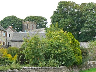
Hope is a village and civil parish in the Derbyshire Peak District, in England. The population at the 2011 Census was 864. It lies in the Hope Valley, at the point where Peakshole Water flows into the River Noe. To the north, Win Hill and Lose Hill stand either side of the Noe.
Bolsover is a market town and the administrative centre of the Bolsover District, Derbyshire, England. It is 145 miles (233 km) from London, 18 miles (29 km) from Sheffield, 26 miles (42 km) from Nottingham and 27 miles (43 km) from Derby. It is the main town in the Bolsover district.

Alfreton is a town and civil parish in the Amber Valley district of Derbyshire, England. The town was formerly a Norman Manor and later an Urban District. The population of the Alfreton parish was 7,971 at the 2011 Census. The villages of Ironville, Riddings, Somercotes and Swanwick were historically part of the Manor and Urban District, and the population including these was 24,476 in 2001.

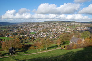
Heanor (/ˈhiːnə/) is a town in the Amber Valley district of Derbyshire in the East Midlands of England. It lies 8 miles (13 km) north-east of Derby and forms, with the adjacent village of Loscoe, the civil parish and town council-administered area of Heanor and Loscoe, which had a population of 17,251 in the 2011 census.

Wirksworth is a market town in the Derbyshire Dales district of Derbyshire, England. Its population of 5,038 in the 2011 census was estimated at 5,180 in 2019. Wirksworth contains the source of the River Ecclesbourne. The town was granted a market charter by Edward I in 1306 and still holds a market on Tuesdays in the Memorial Gardens. The parish church of St Mary's is thought to date from 653. The town developed as a centre for lead mining and stone quarrying. Many lead mines were owned by the Gell family of nearby Hopton Hall.

Tideswell is a village and civil parish in the Peak District of Derbyshire, England. It lies 6 miles (9.7 km) east of Buxton on the B6049, in a wide valley on a limestone plateau, at an altitude of 1,000 feet (300 m) above sea level, and is within the District of Derbyshire Dales. The population was 1,820 in 2001, increasing slightly to 1,827 at the 2011 Census, making it the second-largest settlement within the National Park, after Bakewell. Tideswell Dale is a short limestone valley leading south from the village to the River Wye valley.
Duffield is a village in the Amber Valley district of Derbyshire, 5 miles (8.0 km) north of Derby. It is centred on the western bank of the River Derwent at the mouth of the River Ecclesbourne. It is within the Derwent Valley Mills World Heritage Area and the southern foothills of the Pennines.

Swadlincote is a former mining town in the district of South Derbyshire, England, lying within The National Forest area. It borders the counties of Leicestershire and Staffordshire, 5 miles (8 km) south-east of Burton upon Trent and north-west of Ashby-de-la-Zouch, and 11.5 miles (19 km) south-west of Derby. It also covers Newhall, Oversetts, Midway and the villages of Church Gresley and Woodville, with the sub-district of Goseley. It has a population of some 36,000. Castle Gresley is 2 miles (3 km) to the south-west and Albert Village 1.5 miles (2 km) to the south.

Whaley Bridge is a town and civil parish in the High Peak district of Derbyshire, England. It is situated on the River Goyt, 16 miles (26 km) south-east of Manchester, 7 miles (11 km) north of Buxton, 9 miles (14 km) north-east of Macclesfield and 28 miles (45 km) west of Sheffield. It had a population of 6,455 at the 2011 census, including Furness Vale, Horwich End, Bridgemont, Fernilee, Stoneheads and Taxal.

Ashover is a village and civil parish in the English county of Derbyshire. It is in the North East Derbyshire district of the county. The population of the civil parish taken at the 2011 Census was 1,905. It sits in a valley, not far from the town of Matlock and the Peak District national park.

Ironville in Derbyshire, England, was built about 1830 by the Butterley Company as a model village to house its workers. The population of the civil parish was 1,930 at the 2021 Census. It is situated between Riddings and Codnor Park.
Swanwick is a village in Derbyshire, England, also a parish within the Amber Valley district, with a population of 5,316 at the 2001 census, falling to 5,084 at the 2011 Census. It has a number of shops, pubs and other businesses, a Church of St Andrews, as well as Methodist and Baptist churches. In the northern part of the parish an industrial estate on the former Swanwick Colliery site incorporates the Thornton's Confectionery factory along with other businesses. There is also a Christian conference centre, the largest in the UK. Now largely urbanised, the parish still has some remaining agricultural land to the north and west.

Codnor is a village and civil parish in the Amber Valley district of Derbyshire, England. Codnor is a former mining village and had a population of 3,766 taken at the 2011 Census. It is approximately 12 miles from Derby and 14 miles from Nottingham. Codnor forms a built up area with nearby Ripley.

Little Eaton is a village and civil parish in the English county of Derbyshire. The population as taken at the 2011 Census was 2,430. The name originated from Anglo Saxon times and means the "little town by the water".

Newton is a village in the Bolsover district of Derbyshire, England, about a mile south of Tibshelf. Population details are included in the civil parish of Blackwell.
Wetton is a village in the Peak District National Park, North Staffordshire, at the top of the east side of the Manifold Valley. The population recorded in the 2001 Census was 157. At the time of the 2011 Census the population was recorded under Ilam. This article describes the location, some of the main features of the village, and a number of places of historical or general interest in or near the village. These include Long Low, Wetton, a prehistoric burial site unique to England.
Hartington Middle Quarter is a civil parish within the Derbyshire Dales district, which is in the county of Derbyshire, England. Formerly a part of Hartington parish, for which it is named, it has a mix of a number of villages and hamlets amongst a mainly rural and undulating landscape, and is wholly within the Peak District National Park. It had a population of 379 residents in 2011. The parish is 130 miles (210 km) north west of London, 20 miles (32 km) north west of the county city of Derby, and 5 miles (8.0 km) south east of the nearest market town of Buxton. Being on the edge of the county border, it shares a boundary with the parishes of Chelmorton, Flagg, Hartington Town Quarter, Hartington Upper Quarter, Middleton and Smerrill, Monyash in Derbyshire, as well as Hollinsclough, Longnor and Sheen in Staffordshire.
Middleton and Smerrill is a civil parish within the Derbyshire Dales district, in the county of Derbyshire, England. Largely rural except for the village of Middleton-by-Youlgreave and isolated farms, Middleton and Smerrill's population is 137 residents in 2011. It is 130 miles (210 km) north west of London, 20 miles (32 km) north west of the county city of Derby, and 4+1⁄2 miles (7.2 km) south west of the nearest market town of Bakewell. Middleton and Smerrill is wholly within the Peak District national park, in the southern part of the area. It is one of the largest parishes but among the smallest by way of residents, and shares a border with the parishes of Gratton, Hartington Middle Quarter, Hartington Nether Quarter, Hartington Town Quarter, Monyash and Youlgreave. There are 31 listed structures in Middleton and Smerrill.

