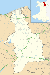
This is a categorised list of places in the principal area of Flintshire, north Wales. See the list of places in Wales for places in other principal areas.
See the article on electoral wards for an explanation of this list.
This is a list of local communities:

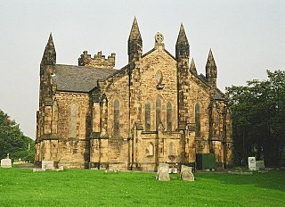
Hawarden is a village, community and electoral ward, in Flintshire, Wales. It is located as part of the Deeside conurbation on the Wales-England border and is home to Hawarden Castle. In the 2011 census, the ward of the same name had a population of 1,887, whereas the community of the same name, which also includes Ewloe, Mancot and Aston had a population of 13,920. The scenic, wooded Hawarden Park abuts the clustered settlement in the south. Hawarden Bridge constitutes distribution and industrial business premises beyond Shotton/Queensferry and the Dee. The west of the main street is called 'The Highway', its start marked by the crossroads with a fountain in the middle, near which are public houses, some centred on restaurants.
Denbighshire is a county in the north-east of Wales. Its borders differ from the historic county of the same name. This part of Wales contains the country's oldest known evidence of habitation – Pontnewydd (Bontnewydd-Llanelwy) Palaeolithic site has Neanderthal remains of some 225,000 years ago. Castles include Denbigh, Rhuddlan, Ruthin, Castell Dinas Bran and Bodelwyddan. St Asaph, one of Britain's smallest cities, has one of its smallest Anglican cathedrals. Denbighshire is bounded by coastline to the north and hills to the east, south and west. The River Clwyd follows a broad valley with little industry: crops appear in the Vale of Clwyd and cattle and sheep in the uplands. The coast attracts summer visitors; hikers frequent the Clwydian Range, part of the Clwydian Range and Dee Valley Area of Outstanding Natural Beauty. Llangollen International Musical Eisteddfod takes place each July.

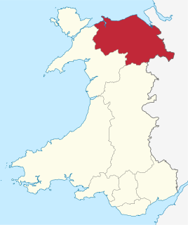
Flintshire is a county in the north-east of Wales. It borders England to the east, Denbighshire to the west and Wrexham County Borough to the south. It is named after the historic county of the same name which has notably different borders. Flintshire is considered part of the Welsh Marches and formed part of the historic Earldom of Chester and Flint. The county is governed by Flintshire County Council which has its main offices in County Hall, Mold.
Flintshire, also known as the County of Flint, is one of Wales' thirteen historic counties, and a former administrative county. It mostly lies on the north-east coast of Wales.
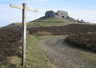
Moel Famau is the highest hill in the Clwydian Range and the highest point of the county of Flintshire in Wales. It lies on the boundary between Denbighshire and Flintshire. The hill, which also gives its name to the Moel Famau country park, has been classed as an Area of Outstanding Natural Beauty since 1985. It is also surrounded by several well-preserved Iron Age hill forts. It is not, as many people think, the highest peak in North-East Wales; this honour goes to Cadair Berwyn. It is also the third-highest peak in the extended AONB of the Clwydian Range and Dee Valley.
Clwyd is a preserved county of Wales, situated in the north-east corner of the country; it is named after the River Clwyd, which runs through the area. To the north lies the Irish Sea, with the English ceremonial counties of Cheshire to the east and Shropshire to the south-east. Powys and Gwynedd lie to the south and west respectively. Clwyd also shares a maritime boundary with Merseyside along the River Dee. Between 1974 and 1996, a slightly different area had a county council, with local government functions shared with six district councils. In 1996, Clwyd was abolished, and the new principal areas of Conwy County Borough, Denbighshire, Flintshire and Wrexham County Borough were created; under this reorganisation, "Clwyd" became a preserved county, with the name being retained for certain ceremonial functions.
The Maelor is an area of north-east Wales along the border with England. It is now entirely part of Wrexham County Borough.

North Wales, also known as the North of Wales, is a geographic region of Wales, encompassing its northernmost areas. It borders Mid Wales to the south, England to the east, and the Irish Sea to the north and west. The area is highly mountainous and rural, with Snowdonia National Park and the Clwydian Range and Dee Valley, known for its mountains, waterfalls and trails, located wholly within the region. Its population is more concentrated in the north-east, and northern coastal areas of the region, whilst significant Welsh-speaking populations are situated in its western and rural areas. North Wales is imprecisely defined, lacking any exact definition or administrative structure. For the public purposes of health, policing and emergency services, and for statistical, economic and cultural purposes, North Wales is commonly defined administratively as its six most northern principal areas, but other definitions of the geographic region exist, with Montgomeryshire historically considered to be part of the region.
This is a list of lists of places in Wales.
Bagillt is a market town and community in Flintshire, Wales. The town overlooks the Dee Estuary and is between the towns of Holywell and Flint. At the 2001 Census the population was recorded as 3,918, increasing to 4,165 at the 2011 census. The community also includes the villages of Walwen and Whelston.

Sychdyn or Soughton is a village in Flintshire, Wales. It is situated on the A5119 road, and is just over 1000 yards (1 km) north of the county town of Mold.

Threapwood is a small village and civil parish in the unitary authority of Cheshire West and Chester and the ceremonial county of Cheshire, England. It is close to the villages of Shocklach, Worthenbury and Malpas.

The Roman Catholic Diocese of Wrexham, is a diocese of the Latin Rite of the Roman Catholic Church in Wales. The diocese is a suffragan of the Archdiocese of Cardiff, directly subject to the authority of the Pope.
Deeside College is now part of Coleg Cambria.
The North Wales Fire and Rescue Service is the fire and rescue service covering the principal areas of Anglesey, Conwy, Denbighshire, Flintshire, Gwynedd and Wrexham in the north of Wales. With service coverage in north-west Wales being predominantly rural. The NWFRS is headquartered in St Asaph, Denbighshire, Wales.
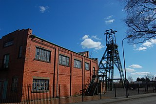
The North Wales Coalfield comprises the Flintshire Coalfield in the north and the Denbighshire Coalfield in the south. It extends from Point of Ayr in the north, through the Wrexham area to Oswestry in Shropshire in the south. A much smaller area on Anglesey where coal was formerly mined is not usually considered to form a part of the coalfield, although it is geographically in the North Wales region.

Wales has traditionally been divided into a number of ambiguous and undefined areas described as "regions", reflecting historical, geographical, administrative, cultural and electoral boundaries within the country. Presently, the most common form of division of Wales into "regions" has been using cardinal and intercardinal references, north or south-west for example. None of the variously described "regions" have official status or defined boundaries, there is neither a fixed number of regions. Various organisations use different regions and combinations of regions for their individual purposes. This includes devolved institutions, such as Visit Wales, Natural Resources Wales, and the Welsh Government itself, using different sets of Wales' regions. Wales is most commonly sub-divided into between two and four regions, with a North–South divide, and North, Mid, South East and South West division being common. This article will list the various terms applied to be the "regions of Wales" and the regions used by various organisations.
