A Peruvian postal code is a five-digit string that comprises part of a postaladdress in Peru. Prior to 2011, only the major cities of Lima and Callao used postal codes. However, in February 2011 a nationwide system was implemented which employs a five-digit numeric format. Similar to the postal codes of Mexico, Brazil, Australia, the United States, and elsewhere, postal codes in Peru are strictly numerical, using only numbers.
The first two digits of the postal code identify the administrative region or department, whereas the final two digits represents a specific district or location within a district. The middle digit does not strictly relate to specific provinces, therefore it is possible and indeed common for one province to be split amongst multiple postal zones.
For example, the province of Chachapoyas contains portions of postal zones 010, 012, 013 and 014 whereas postal zone 011 is entirely within Bongará Province. Regardless, it can be understood that all five postal zones are within the Department of Amazonas, since they all begin with the digits 01.
An online tool to search for postal codes can be found here.
Postal codes
The following chart lists the various postal codes in use throughout Peru. Each department or region is assigned a two-digit regional code. This makes up the beginning of the postal code. The final two digits comprise a geographic code which denotes a specific district or area within a district. The middle digit is not tied to administrative boundaries. Final digits other than "0" or "5" tend to denote urban or built-up areas, though this is not always the case.
Therefore, the postal code for the district of Jazan, in the Amazones Region, is 01130, whereas the postal code for the city of Pedro Ruiz Gallo within Jazan district, is 01131.
Similarly, while the district of Conchuccos has the postal code 02875, the urban city of the same name uses the postal code 02876.
A postal code is a series of letters or digits or both, sometimes including spaces or punctuation, included in a postal address for the purpose of sorting mail.
Lima is the capital and the largest city of Peru. It is located in the valleys of the Chillón, Rímac and Lurín Rivers, in the desert zone of the central coastal part of the country, overlooking the Pacific Ocean. Together with the seaport of Callao, it forms a contiguous urban area known as the Lima Metropolitan Area. With a population of more than 9.5 million, Lima is one of the largest cities in the Americas.
The Lima Metro is a rapid transit system that serves the area of the cities of Lima and Callao, both of which make up the Lima metropolitan area, currently linking the district of Villa El Salvador in the south of Lima with San Juan de Lurigancho in the northeast of the same city.
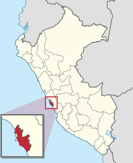
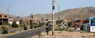
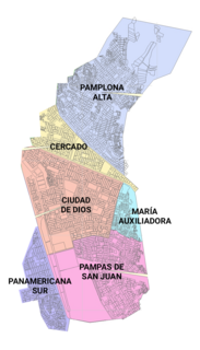
Villa El Salvador (VES) is an urban, largely residential coastal district on the outskirts of Lima, Peru. It borders the district of Chorrillos on the east; the Pacific Ocean on the southwest; Lurín on the southeast; Villa María del Triunfo on the east and San Juan de Miraflores on the north.
Lima is a district of Lima Province in Peru. Lima district is the oldest in Lima Province and as such, vestiges of the city's colonial era remain today in the historic centre of Lima, which was declared a UNESCO World Heritage Site in 1988 and contains the foundational area known as Cercado de Lima.
Lima Province is located in the central coast of Peru and is the only province in the country not belonging to any of the twenty-five regions. Its capital is Lima, which is also the nation's capital.
The Lima Metropolitan Area is an area formed by the conurbation of the Peruvian provinces of Lima and Callao. It is the largest of the metropolitan areas of Peru, the seventh largest in the Americas, the fourth largest in Latin America, and among the thirty largest in the world. The conurbation process started to be evident in the 1980s.
San Juan de Lurigancho (SJL) is a district in Lima, Peru, located in the area known as Cono Este. It is Peru's most populous district, with a current population that may have exceeded one million.
Miraflores is a district of the Lima Province in Peru. It is an exclusive residential and upscale shopping district south of downtown Lima. It is also one of the most affluent districts that make up the city of Lima. It has various hotels, restaurants, bars, nightclubs, and department stores. Miraflores is one of the main tourist attractions in Lima.
Ate, also known as Ate-Vitarte, is a district of the Lima Province in Peru. Located in the eastern part of the province, it is one of the districts that comprise the city of Lima.
Lurigancho-Chosica is a district of Lima Province, Peru, located in the valley of the Rímac River which it shares with neighboring Chaclacayo and Ate districts. It was created on January 2, 1857. Its capital is the town of Chosica. The district has a total land area of 236.47 km2 (91.30 sq mi). Its administrative center is located 861 m (2,825 ft) above sea level.
Santa Rosa is a district of the Lima Province in Peru. Officially established as a district on February 6, 1962. The district's postal code is 38. It limits to the north and the east with the Ancón District, to the west with the Pacific Ocean, to the south with the Ventanilla District.
El Agustino is a district of the Lima Province in Peru. It is part of city of Lima. Officially established as a district on January 6, 1965, the current mayor (alcalde) of El Agustino is Víctor Modesto Salcedo Ríos. The district's postal code is 10.
San Juan de Miraflores is a district of the Lima Province in Peru. It is located in the Cono Sur area of the city of Lima.
Carabayllo is one of the 43 districts of the province Lima in Peru. It is located in the Cono Norte area of the province and was founded by General José de San Martín in August 1821 at which time it was the only district to occupy the area north of the Rímac River up to the province Canta.
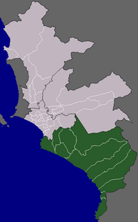
The Cono Sur is one of the five areas that make up the Lima Metropolitan Area. It is located in the southern part of the metropolis hence its name. This socioeconomic levels of this district are varied. Most of the population however belongs to the lower and middle classes. But it is the area closest to the districts of the modern zone and residential areas like Miraflores, La Molina, Santiago de Surco,etc. Many of the residents belonging to these districts are immigrants from various regions of the country. As they settled there, some developed successful communities such as Villa El Salvador, while others still live in poor housing known as Pueblos jóvenes. The area is popular for its beaches, farms and factories in that population greatly increases during the summer months.
Public transport in Lima is handled by buses, micros, taxicabs, and the so-called mototaxis. Micros are the most common means of public transportation in Lima and many other cities in Peru. There are also more than 100 kilometres (62 mi) of cycle paths in the city.
Comunidad Cristiana Agua Viva is a charismatic evangelical megachurch in Lima, Peru. As of 2017, it has seven locations in Lima Province.
This page is based on this Wikipedia article Text is available under the CC BY-SA 4.0 license; additional terms may apply. Images, videos and audio are available under their respective licenses.