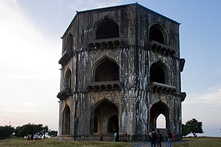
Ahmednagar district is a district in state of Maharashtra in India. There are 14 talukas (talukas) in Ahmednagar.
Ahmednagar district is divided into four district subdivisions.
The Table below list all 14 talukas of Ahmednagar district in the Indian state of Maharashtra along with district subdivision, area, largest city and location map in the district information. [1]
Name of taluka | District Subdivision | Area (km2) | % of District Area | Largest City | Location on District Map |
---|---|---|---|---|---|
Akole | Sangamner | 1505.08 | 8.64% | Akole | |
Jamkhed | Karjat | 878.62 | 5.05% | Jamkhed | |
Karjat | Karjat | 1503.61 | 8.64% | Karjat | |
Kopargaon | Sangamner | 725.16 | 4.16% | Kopargaon | |
Nagar | Ahmednagar | 1605.74 | 9.22% | Ahmednagar | |
Nevasa | Shrirampur | 1343.43 | 7.72% | Nevasa | |
Parner | Ahmednagar | 1930.28 | 11.09% | Parner | |
Pathardi | Ahmednagar | 1214.10 | 6.97% | Pathardi | |
Rahata | Shrirampur | 759.19 | 4.36% | Rahata | |
Rahuri | Shrirampur | 1035.11 | 5.94% | Rahuri | |
Sangamner | Sangamner | 1705.06 | 9.79% | Sangamner | |
Shevgaon | Ahmednagar | 1031.85 | 5.93% | Shevgaon | |
Shrigonda | Karjat | 1605.61 | 9.22% | Shrigonda | |
Shrirampur | Shrirampur | 569.87 | 3.27% | Shrirampur |
The table below lists important geographic and demographic parameters for all 14 talukas of Ahmednagar district. Population data is extracted from the 2001 Census of India. [2]
taluka Name | Population (2001 census) | % of District Population | Male | Male(%) | Female | Female(%) | Sex Ratio | Literacy | Literacy(%) | Literate Male | Literate Male(%) | Literate Female | Literate Female(%) |
---|---|---|---|---|---|---|---|---|---|---|---|---|---|
Akole | 271719 | 6.65 | 137617 | 50.65 | 134102 | 49.35 | 974 | 160734 | 59.15 | 95179 | 69.16 | 65555 | 48.88 |
Jamkhed | 134238 | 3.28 | 68837 | 51.28 | 65401 | 48.72 | 950 | 58868 | 43.85 | 36270 | 52.69 | 22598 | 34.55 |
Karjat | 205585 | 5.03 | 106347 | 51.73 | 99238 | 48.27 | 906 | 190227 | 92.53 | 109470 | 102.94 | 80757 | 81.38 |
Kopargaon | 276937 | 6.77 | 143502 | 51.82 | 133435 | 48.18 | 930 | 177516 | 64.1 | 104488 | 72.81 | 73028 | 54.73 |
Nagar | 651569 | 15.94 | 341864 | 52.47 | 309705 | 47.53 | 906 | 483736 | 74.24 | 274906 | 80.41 | 208830 | 67.43 |
Nevasa | 326611 | 7.99 | 168561 | 51.61 | 158050 | 48.39 | 938 | 207717 | 63.6 | 122225 | 72.51 | 85492 | 54.09 |
Parner | 246535 | 6.03 | 123902 | 50.26 | 122633 | 49.74 | 990 | 153625 | 62.31 | 89698 | 72.39 | 63927 | 52.13 |
Pathardi | 214819 | 5.25 | 110075 | 51.24 | 104744 | 48.76 | 936 | 130993 | 60.98 | 78886 | 71.67 | 52107 | 49.75 |
Rahata | 288003 | 7.04 | 148642 | 51.61 | 139361 | 48.39 | 938 | 196296 | 68.16 | 112294 | 75.55 | 84002 | 60.28 |
Rahuri | 294748 | 7.21 | 152275 | 51.66 | 142473 | 48.34 | 936 | 193498 | 65.65 | 112350 | 73.78 | 81148 | 56.96 |
Sangamner | 439806 | 10.76 | 226022 | 51.39 | 213784 | 48.61 | 946 | 286779 | 65.21 | 167277 | 74.01 | 119502 | 55.9 |
Shevgaon | 203747 | 4.98 | 104342 | 51.21 | 99405 | 48.79 | 953 | 173398 | 85.1 | 99460 | 95.32 | 73938 | 74.38 |
Shrigonda | 277319 | 6.78 | 143015 | 51.57 | 134304 | 48.43 | 939 | 176826 | 63.76 | 103101 | 72.09 | 73725 | 54.89 |
Shrirampur | 256441 | 6.27 | 131500 | 51.28 | 124941 | 48.72 | 939 | 176826 | 68.95 | 103101 | 78.4 | 73725 | 59.01 |
The Table below list all 14 talukas of Ahmednagar district in the Indian state of Maharashtra by average rain fall along with each year rainfall information from 1981 to 2004. [3]
taluka | Average | 1981 | 1982 | 1983 | 1984 | 1985 | 1986 | 1987 | 1988 | 1989 | 1990 | 1991 | 1992 | 1993 | 1994 | 1995 | 1996 | 1997 | 1998 | 1999 | 2000 | 2001 | 2002 | 2003 | 2004 |
---|---|---|---|---|---|---|---|---|---|---|---|---|---|---|---|---|---|---|---|---|---|---|---|---|---|
Akole | 508.9 | 404 | 396 | 445 | 374 | 184 | 244 | 296 | 734 | 444 | 503 | 544 | 404.5 | 636.3 | 509.8 | 374 | 620 | 587 | 814.5 | 403 | 439 | 473 | 445 | 489 | 1074 |
Jamkhed | 583.3 | 527 | 555 | 1341 | 727 | 540 | 872 | 996 | 1040 | 920 | 523 | 480 | 603.2 | 823 | 583.3 | 570 | 922 | 427 | 1070 | 409 | 661 | 333 | 561 | 460 | 570 |
Karjat | 493 | 542 | 552 | 779 | 532 | 456 | 637 | 432 | 689 | 864 | 597 | 391 | 352 | 651 | 493 | 498 | 514 | 328 | 920 | 405 | 400 | 495 | 436 | 281 | 565 |
Kopargaon | 440.2 | 420 | 389 | 531 | 518 | 300 | 319 | 460 | 575 | 594 | 499 | 296 | 418 | 408 | 440.2 | 321 | 537 | 290 | 582 | 384 | 428 | 360 | 366 | 280 | 428 |
Nagar | 531.1 | 639 | 520 | 786 | 497 | 400 | 498 | 827 | 772 | 914 | 1446 | 950 | 572 | 655 | 531.1 | 372 | 710 | 347 | 730 | 479 | 580 | 380 | 394 | 199 | 518 |
Nevasa | 531.3 | 366 | 185 | 701 | 407 | 302 | 375 | 488 | 583 | 593 | 786 | 395 | 380 | 447 | 531.3 | 664 | 623 | 312 | 681 | 461 | 516 | 312 | 305 | 219 | 508 |
Parner | 486.9 | 622 | 869 | 540 | 575 | 714 | 313 | 472 | 738 | 713 | 630 | 442 | 551 | 696 | 486.9 | 259 | 656 | 361 | 702 | 245 | 456 | 384 | 438 | 190 | 695 |
Pathardi | 580.4 | 483 | 346 | 927.2 | 351 | 824 | 318 | 714 | 807 | 701 | 716 | 485 | 434.5 | 720 | 571.6 | 533 | 932 | 448 | 1095 | 360 | 471 | 332 | 502 | 476 | 595 |
Rahata | 441.0 | NA | NA | NA | NA | NA | NA | NA | NA | NA | NA | NA | NA | NA | NA | NA | NA | NA | NA | NA | 525 | 413 | 385 | 249 | 490 |
Rahuri | 455 | 639 | 434 | 665 | 427 | 301 | 242 | 533 | 725 | 524 | 788 | 466 | 407 | 548 | 455 | 642 | 555 | 345 | 585 | 581 | 587 | 358 | 302 | 299 | 509 |
Sangamner | 416.6 | 459 | 315 | 363 | 204 | 204 | 260 | 306 | 461 | 558 | 445 | 450 | 342 | 435 | 416.6 | 290 | 566 | 402 | 489 | 348 | 528 | 337 | 459 | 380 | 570 |
Shevgaon | 584.6 | 314 | 407 | 563 | 309 | 247 | 422 | 596 | 824 | 730 | 697 | 391 | 369 | 519 | 584.6 | 363 | 782 | 226 | 780 | 366 | 531 | 349 | 449 | 320 | 715 |
Shrigonda | 448.6 | 614 | 438 | 521.6 | 496 | 359 | 460 | 497 | 531 | 610 | 614 | 438 | 521.6 | 496 | 359 | 460 | 497 | 531 | 610 | 571 | 392 | 352 | 334 | 87 | 527 |
Shrirampur | 464 | 880 | 373 | 668 | 350 | 392 | 335 | 582 | 546 | 585 | 752 | 401 | 456 | 566 | 463.9 | 508 | 611 | 312 | 819 | 315 | 354 | 341 | 391 | 313 | 485 |
Ahmednagar district is the largest district of Maharashtra state in western India. The historical Ahmednagar city is the headquarters of the district. Ahmednagar and Sangamner are the largest cities in the district. It was the seat of the Ahmednagar Sultanate of late medieval period. This district is known for the towns of Shirdi associated with Sai Baba, Meherabad associated with Meher Baba, Shani Shinganapur with Shanidev, and Devgad with Lord Dattatreya. Ahmednagar district is part of Nashik Division. The district is bordered by Aurangabad district to the northeast, Nashik district to the northwest, Thane and Pune districts to the southwest, Solapur district to the south and Beed district to the southeast.
Jamkhed taluka, is a taluka in Karjat subdivision of Ahmednagar district in Maharashtra State of India.
Karjat taluka is a taluka in Karjat subdivision of Ahmednagar district in Maharashtra state of western India.
Kopargaon taluka is a taluka in Shirdi subdivision of Ahmednagar district in Maharashtra state of India.
Nagar taluka is a taluka in Ahmednagar subdivision of Ahmednagar district in Maharashtra state of India.
Nevasa taluka (Newasa), is a taluka in Shrirampur subdivision of Ahmednagar district in Maharashtra state of India. Nevasa is a place where Sant Dnyaneshwar wrote the Dnyaneshwari.
Pathardi taluka is a taluka in Ahmednagar subdivision of Ahmednagar district in Maharashtra state of India.
Rahata taluka, is a taluka in Shrirampur subdivision of Ahmednagar district in Maharashtra State of India.
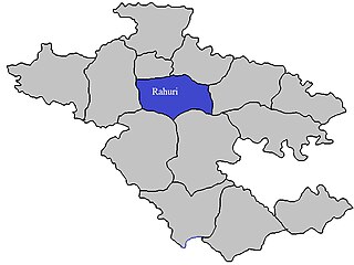
Rahuri taluka, is a taluka in the Shrirampur subdivision of the Ahmednagar district in Maharashtra, western India.
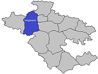
Sangamner taluka, is a taluka in Sangamner subdivision of Ahmednagar district in Maharashtra state of India.
Shevgaon taluka is a taluka in Ahmednagar subdivision of Ahmednagar district in Maharashtra state of India.
Shrigonda Taluka, is a taluka in Karjat subdivision of Ahmednagar District in Maharashtra state of India. Its administrative headquarters is the town of Shrigonda.
Shrirampur taluka, is a taluka in Shrirampur subdivision of Ahmednagar district in Maharashtra state of India.
Daund taluka is a taluka or subdivision of Pune district of the state of Maharashtra in India. The town of Daund is the only major urban area in this predominantly rural area. Daund railway station is a major railway junction. All southern railways are connected to this route, and also divided the Nagar railway to north Indian railway, like Delhi, Solapur division, Daund junction and then joined to the Pune district junction. To reach the Siddhi Vinayak Siddhatek Ganpati temple, one has to travel 14 km to Daund by road.
Chandrapur, is a village in Rahata taluka of Ahmednagar district in the Indian state of Maharashtra. It is located in south-west part of Rahata taluka and borders with Sangamner taluka.