List of the highest points of the German states

Last updated

Relief Map of Germany.svg
Red pog.svg
Feldberg
(1493)
Red pog.svg
Zugspitze
(2962.06)
Red pog.svg
Arkenberge
(122)
Red pog.svg
Hasselbrack
(116.2)
Red pog.svg
Wasserkuppe
(950.0)
Red pog.svg
Helpt Hills
(179.2)
Red pog.svg
Wurmberg
(971.2)
Red pog.svg
Langenberg
(843.2)
Red pog.svg
Erbeskopf
(816.32)
Red pog.svg
Dollberg
(695.4)
Red pog.svg
Fichtelberg
(1214.8)
Red pog.svg
Brocken
(1141.2)
Red pog.svg
Bungsberg
(167.4)
The highest points in the German states
Elevations in metres (m) above sea level (NHN)

This list of the highest points of the German states shows the highest mountain or hill in each German federal state together with its height and links to lists of other mountains and hills.

Contents

Overview

At 2,962.06 m above  sea level (NHN) , the highest mountain in Germany is Bavaria's Zugspitze, whose height until 2000 was given as 2,961.47 m above  sea level (NN) . [1] The lowest height occurs in the city of Bremen: at 32.5 m the highest natural point of the smallest German state is located in Friedehorst Park in the Bremen quarter of Burglesum, although the rubbish tip in Bremen-Blockland, whose summit reaches 49 m, is higher. The highest natural point in the capital city of Berlin, the Große Müggelberg, is, at 114.7 m [2] still 5.4 metres lower than the rubble heap of the Teufelsberg, which was piled up after the Second World War and reaches a height of 120.1 m; [3] but the highest point in Berlin is an artificially created mound of the Arkenberge, which attains a height of about 122 m. [4] Together with the highest points of the states of Hamburg, Schleswig-Holstein and Mecklenburg-Vorpommern, none reaches a height of 200 m.

At 201 m, the Kutschenberg is the highest summit in Brandenburgs. However, the highest point in the state is actually a spot on the Heidehöhe which reaches 201.4 m, but whose summit lies a few metres over the border in the neighbouring state of Saxony. [5]

The only summit of the sixteen that is not marked by a summit cross or a stone is the rise in Friedehorst Park. The summit of the Großer Beerberg lies within a biosphere reserve and is not, therefore, accessible to the public. However, peak baggers may count the observation platform which lies just below the summit. [5]

List

This list of the highest mountains or hills in each of the German states is sorted by height in metres (m) above sea level (NHN):

StateMountain or hill Elevation Location Range Isolation Prominence Image
Baden-Württemberg
(List)
Feldberg 1493.0 m [6] 47°52′25″N08°00′14″E / 47.87361°N 8.00389°E / 47.87361; 8.00389 Black Forest 97 km
Rossberg (CH)
930 m Feldberg fg1.jpg
Bavaria
(List)
Zugspitze 2962.06 m [1] 47°25′16.38″N10°59′10.73″E / 47.4212167°N 10.9863139°E / 47.4212167; 10.9863139 Northern Limestone Alps 24.6 km
Acherkogel (A)
1746 m Zugspitze Westansicht.JPG
Berlin
(List)
Arkenberge 122 m [4] 52°38′23.7″N13°24′27.7″E / 52.639917°N 13.407694°E / 52.639917; 13.407694 (Arkenberge_text:ICON2) Arkenberge-hill1.JPG
Brandenburg
(List)
Kutschenberg 201 m [7] 51°21′55″N13°43′38″E / 51.36528°N 13.72722°E / 51.36528; 13.72722 Kmehlen Hills Kutschenberg 01.jpg
Bremen
(List)
Eminence in Friedehorst Park 32.5 m [8] 53°10′44″N08°40′28″E / 53.17889°N 8.67444°E / 53.17889; 8.67444 Friedhorstpark 20160619.jpg
Hamburg
(List)
Hasselbrack 116.2 m [9] 53°25′49″N9°51′50″E / 53.43033°N 9.86388°E / 53.43033; 9.86388 Harburg Hills 0.46 km
→ unnamed hillock (120.4 m) in the Wulmstorf and Daerstorf Forest
3.4 km
Gannaberg (155 m)
Hasselbrack-Stein DSCN0857 small.JPG
Hesse
(List)
Wasserkuppe 950.0 m [6] 50°29′53″N9°56′16″E / 50.49806°N 9.93778°E / 50.49806; 9.93778 Rhön 60 km
Großer Beerberg
585 m Radarstation Wasserkuppe 01114.JPG
Mecklenburg-Vorpommern
(List)
Helpt Hills 179.2 m [10] 53°29′21″N13°36′53″E / 53.48917°N 13.61472°E / 53.48917; 13.61472 Helpt Hills Helpt Helpter Berge Sendeturm Panorama 2011-05-06 182.JPG
Lower Saxony
(List)
Wurmberg 971.2 m [11] 51°45′24″N10°37′8″E / 51.75667°N 10.61889°E / 51.75667; 10.61889 Harz 3 km
Brocken
182 m Wurmberg Harz.JPG
North Rhine-Westphalia
(List)
Langenberg 843.2 m [12] 51°16′35.27″N08°33′30.26″E / 51.2764639°N 8.5584056°E / 51.2764639; 8.5584056 Rothaar Mountains 116 km
Großer Feldberg
557 m LangenbergBlickWinter.jpg
Rhineland-Palatinate
(List)
Erbeskopf 816.32 m [13] 49°43′46″N7°5′20″E / 49.72944°N 7.08889°E / 49.72944; 7.08889 Hunsrück 113 km571 m Erbeskopf09.jpg
Saarland
(List)
Dollberg 695.4 m [14] 49°37′47″N07°00′52″E / 49.62972°N 7.01444°E / 49.62972; 7.01444 Dollberge Dollberg1.jpg
Saxony
(List)
Fichtelberg 1214.8 m [15] 50°25′46″N12°57′15″E / 50.42944°N 12.95417°E / 50.42944; 12.95417 Ore Mountains 3.4 km
Klínovec (CZ)
135 m Pano keilberg fichtelberg.jpg
Saxony-Anhalt
(List)
Brocken 1141.2 m [16] 51°47′57″N10°36′56″E / 51.7991°N 10.6156°E / 51.7991; 10.6156 Harz 224 km
Fichtelberg
856 m Brocken vom Torfhaus.jpg
Schleswig-Holstein
(List)
Bungsberg 167.4 m [6] 54°12′39″N10°43′26″E / 54.21083°N 10.72389°E / 54.21083; 10.72389 Holstein Switzerland Bungsberg 16.jpg
Thuringia
(List)
Großer Beerberg 982.9 m [6] Beerberg 50°39′34″N10°44′46″E / 50.65944°N 10.74611°E / 50.65944; 10.74611 Thuringian Forest 103 km
Ochsenkopf
389 m Grosser Beerberg.jpg

See also

Related Research Articles

<span class="mw-page-title-main">Großer Feldberg</span>

The Großer Feldberg is, at a height of 879.5 metres, the highest elevation of the Taunus mountains, and of the entire Rhenish Massif. It is situated in the Hochtaunuskreis district in Hesse, Germany.

<span class="mw-page-title-main">Erbeskopf</span> Mountain in southwest Germany

The Erbeskopf is a mountain in the Hunsrück range in central Germany. At a height of 816 metres (2,677 ft), it is the highest point in the state of Rhineland-Palatinate, as well as the highest point of German territory on the western bank of the Rhine. It lies within the Saar-Hunsrück Nature Park.

<span class="mw-page-title-main">Wolfsklippen</span>

The Wolfsklippen, also called the Wolfsklippe, is a granite mountain in the Harz mountains in Central Germany with an observation platform on the summit. Its height is frequently given as about 723 m above sea level (NN), but occasionally also as only around 710 m above NN.

<span class="mw-page-title-main">Ottofelsen</span>

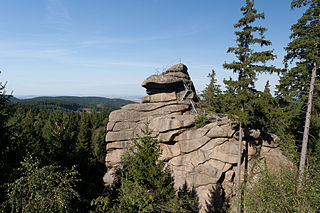
The Ottofels, named after Prince Otto of Stolberg-Wernigerode, is a tor and natural monument near Wernigerode in the Harz mountains of central Germany.

The Schiener Berg, also called the Schienerberg, is a hill ridge between Horn in the county of Constance in the German state of Baden-Württemberg and Stein am Rhein in the district of Stein, in the Swiss canton of Schaffhausen. It is up to 715.6 m above sea level (NHN) and part of the Lake Constance peninsula of Höri in the Southwest Hegau Uplands. The name is derived from the settlement of Schienen which is roughly in the centre of the region Schienen. – von der namensgebenden Ortschaft Schienen aus im Uhrzeigersinn beginnend im Nordwesten betrachtet und die naturräumliche Lage mit einbezogen –

<span class="mw-page-title-main">Helpt Hills</span> Hill range in Germany

The Helpt Hills are the highest natural elevation in the northeast German state of Mecklenburg-Vorpommern reaching a maximum height of 179.2 metres (588 ft) above sea level (NHN). The hills are a terminal moraine formed during the Pomeranian stadium of the Weichselian glaciation and were named after the village of Helpt on their northern slopes.

<span class="mw-page-title-main">Trudenstein</span> Rock formation in Germany

The Trudenstein is a rock formation and popular hiker's destination in the Harz Mountains of central Germany. It is located in the federal state of Saxony-Anhalt.

<span class="mw-page-title-main">Riffelwandspitzen</span>

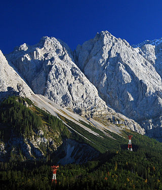
The Riffelwandspitzen are two adjacent mountains in the Wetterstein range in Bavaria. The summit of the Great Riffelwandspitze reaches a height of 2,626 m, the summit of the Little Riffelwandspitze 2,543 m.

The Waupacksee is a lake on the southeastern edge of the town of Waren (Müritz) in the district of Mecklenburgische Seenplatte in the German state of Mecklenburg-Western Pomerania. The lake is 62.5 m above sea level (NHN), it has an area of 6.8 hectares and measures 300 metres by 270 metres. Its only headstream is a ditch from the meadows to the north, a ditch also carries its waters away to the Feisneck which in turn empties into the Müritz. The lake is mostly surrounded by meadows, only the eastern shore has a row of bushes. The shore is covered in reeds so the only access to the lake is from private land on the western shore. A high-tension power line crosses the northern part of the lake.

<span class="mw-page-title-main">Rehberg (Wasgau)</span>

The Rehberg is a prominent hill, 576.8 m above sea level (NHN), in the German state of Rhineland-Palatinate. After the Grand Wintersberg (ca. 581 m) in French North Alsace, the Rehberg is the second highest hill in the Wasgau, the Franco-German region that forms the southern part of the Palatine Forest and runs from the valley of the River Queich to the Col de Saverne. The Rehberg is also the highest hill on German soil in the Wasgau. As part of the Palatine Forest-North Vosges Biosphere Reserve it has been placed under special protection measures.

<span class="mw-page-title-main">Weißenberg (Frankenweide)</span>

The Weißenberg in the Palatine Forest is a hill in the municipality of Merzalben. Its height is variously give as 610 m above sea level (NHN) or 607 m above NHN. The higher value has been officially recommended since 2011. That makes the Weißenberg the highest point in the west of the mountain range, ahead of the Eschkopf and Mosisberg. As part of the Palatine Forest-North Vosges Biosphere Reserve it is protected by special conservation measures.

<span class="mw-page-title-main">Orensberg</span>

The Orensberg, also known in the region as the Orensfels(en) due to the striking rock formations on its summit plateau, is a hill, 581.2 m above sea level (NHN), near Frankweiler in the county of Südliche Weinstraße in the German state of Rhineland-Palatinate. The hill is part of the Haardt mountain range that forms the eastern edge of the Palatinate Forest.

<span class="mw-page-title-main">Schwarzwälder Hochwald</span>

The Schwarzwälder Hochwald, not to be confused with the High Black Forest, is the high south-western part of the Hunsrück in the German states of Saarland and Rhineland-Palatinate. The mountains are up to 816.32 m high.

<span class="mw-page-title-main">Dollberg</span>

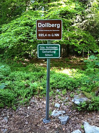
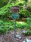
The Dollberg is a mountain in the Dollberge range in central Germany and the highest point in the state of Saarland. It is 695.4 m above sea level (NHN) and lies within the Schwarzwälder Hochwald on the boundary between the counties of Trier-Saarburg (Rhineland-Palatinate) and St. Wendel (Saarland).

<span class="mw-page-title-main">Schimmelkopf</span>

The Schimmelkopf or Weiskircher Höhe is a mountain that rises in the Schwarzwälder Hochwald on the boundary between the counties of Trier-Saarburg (Rhineland-Palatinate) and Merzig-Wadern (Saarland) and, at 694.8 m above sea level (NHN), is the second highest peak in the German state of Saarland.

<span class="mw-page-title-main">Hohwart</span> Mountain in Baden-Württemberg, Germany

The Hohwart is a mountain near the village of Breitnau in the Black Forest in the German state of Baden-Württemberg. It is 1,123 metres high.

The Apert is a forested mountain, 631.3 m above sea level (NHN), in the western Volcanic Eifel, a mountain range in the German state of Rhineland-Palatinate. It rises about two kilometres south of Büdesheim and is the highest point in the parish (Gemarkung).

<span class="mw-page-title-main">Alarmstange</span>

The Alarmstange, at 545.2 m above sea level (NHN), is the highest point in the Montabaur Heights, a hill ride on the southwestern edge of the Westerwald. It lies near Horressen in the county of Westerwaldkreis in the German state of Rhineland-Palatinate. Together with the Köppel and the Lippersberg, the Alarmstange forms the centre of the ridge, on which is the largest contiguous woodland area in the Westerwald.

References

  1. 1 2 "Kundeninformation 3/2009" (pdf; 1,1 MB) (in German). Landesamt für Vermessung und Geoinformation Bayern. September 2009. p. 2. Retrieved 2012-12-13.
  2. Neuvermessung: Jetzt ist der Teufelsberg der Größte. In: Der Tagesspiegel , 27. April 2013
  3. Teufelsberg auf den Seiten des Bezirks Charlottenburg-Wilmersdorf, retrieved, 23 May 2013
  4. 1 2 Arkenberge schlägt Teufelsberg, vom 28. Januar 2015, retrieved, 12 February 2015, auf pankower-allgemeine-zeitung.de
  5. 1 2 "Bezwinger der 16 Riesen". tagesschau.de . Archived from the original on 2011-12-14. Retrieved 2011-12-26.
  6. 1 2 3 4 Map services of the Federal Agency for Nature Conservation
  7. Foto der auf dem Kutschenberg stehenden Stele mit Inschrift, auf commons.wikimedia.org
  8. Der Friedhorstpark (32,5 m) – Höchster Punkt Bremens, in books.google.de
  9. Höhe der Erhebung laut Geologischem Landesamt Hamburg und bis 2013 laut Aufschrift des Gipfelkreuzes
  10. Geodata Viewer by the Mecklenburg-Western Pomerania Office of Geoinformation, Survey and Land Registration (Amt für Geoinformation, Vermessungs- und Katasterwesen Mecklenburg-Vorpommern)
  11. Topographische Karte, TK25, Nr. 4229, Braunlage, M  = 1:25.000
  12. Topographic Information Management, Cologne - NRW GEObasis Division (info)
  13. Artikel Wie hoch ist der Erbeskopf nun wirklich? und gleichnamige Pressemitteilung Archived 2016-03-04 at the Wayback Machine (PDF; 145 kB) des Landesamtes für Vermessung und Geobasisinformation Rheinland-Pfalz vom 17. Januar 2008 auf lvermgeo.rlp.de (retrieved, 31 January and 1 February 2013).
  14. Höhe des Dollbergs laut Dollberge (Karte und Info) auf Saarlandbilder.net und laut Aufschrift des Gipfelschildes
  15. Staatsbetrieb Geobasisinformation und Vermessung Sachsen (GeoSN) . Die nivellitische Bestimmung dieser DHHN92-Höhe wurde am 12. August 2004 von Vertretern des damaligen Landesvermessungsamtes Sachsen (jetzt Staatsbetrieb Geobasisinformation und Vermessung Sachsen) durchgeführt (die Höhe bezieht sich auf die höchste Stelle des Fichtelberges außerhalb baulicher Anlagen). retrieved, 21 December 2010, auf landesvermessung.sachsen.de
  16. Saxony-Anhalt viewer of the State Office for Survey and Geoinformation (Landesamt für Vermessung und Geoinformation)