Listed buildings in Bradford (Royds Ward)

Last updated

Royds is a ward in the metropolitan borough of the City of Bradford, West Yorkshire, England. It contains 30 listed buildings that are recorded in the National Heritage List for England. Of these, two are listed at Grade II*, the middle of the three grades, and the others are at Grade II, the lowest grade. The ward is to the south of the centre of Bradford, and includes the area of Buttershaw, and parts of Horton Bank and Low Moor. The oldest and most important building in the ward is Royds Hall, which is listed, together with a number of associated structures. The other listed buildings consist of houses, cottages and associated structures, farmhouses and farm buildings, public houses, buildings remaining from a former textile mill, a memorial and a school.

Contents

Key

Map all coordinates using: OpenStreetMap  
Download coordinates as: KML
GradeCriteria [1]
II*Particularly important buildings of more than special interest
IIBuildings of national importance and special interest

Buildings

Name and locationPhotographDateNotesGrade
Royds Hall
53°45′01″N1°47′02″W / 53.75026°N 1.78384°W / 53.75026; -1.78384 (Royds Hall)
Royds Hall Manor.JPG
Mid 16th century (probable)A manor house, originally timber framed, it was encased in gritstone in the 17th century, and a right cross-wing was added in about 1770. The roof is in stone slate, and has gables with saddlestones, kneelers, and shaped finials. There are two storeys, and the house consists of a central range with two halls, and cross-wings. On the front is a two-storey gabled porch containing a doorway that has a four-centred arch with spiral carving in the spandrels and a massive lintel, above which is a string course, a dated cartouche, and a stepped window with a hood mould. The other windows are mullioned or mullioned and transomed with hood moulds. The right cross-wing has three storeys, it is canted, and in the gable is a lunette. [2] [3] II*
Stable, coach house and barn,
Royds Hall
53°45′02″N1°47′02″W / 53.75061°N 1.78400°W / 53.75061; -1.78400 (Stable, coach house and barn, Royds Hall)
Royds Hall Court.JPG
1663The outbuildings, which were later extended and altered, form two ranges at right angles. They are in gritstone and sandstone, and have hipped stone slate roofs with bracketed eaves, and there are two storeys. In the north range are four circular windows in the upper floor, and elsewhere the windows are mullioned. One of the doorways has a chamfered, shaped head dated 1663, and there is a re-used doorway dated 1686. On the south range is an external flight of steps leading to a courtroom. [4] [5] II*
Long Court Room, stable and cowbier range, Royds Hall
53°45′01″N1°47′05″W / 53.75032°N 1.78469°W / 53.75032; -1.78469 (Long Court Room, stable and cowbier range, Royds Hall)
1669The range is in gritstone and sandstone and has a stone slate roof with saddlestones at the west end. There is one storey and a loft, and it contains three-light mullioned windows. In the late 18th century a court room was built over the stables at the west end, and this is approached by an external stone staircase. [4] [6] II
Royds Hall Cottages
53°45′02″N1°47′00″W / 53.75068°N 1.78320°W / 53.75068; -1.78320 (Royds Hall Cottages)
Late 17th centuryA pair of gritstone cottages with a stone slate roof and two storeys, The doorways have square jambs, and the windows are mullioned, with some mullions removed. [7] II
Moorside Farmhouse and barn
53°45′14″N1°46′25″W / 53.75400°N 1.77361°W / 53.75400; -1.77361 (Moorside Farmhouse and barn)
Early 18th centuryThe barn dates from the late 18th century, and the farmhouse which has two storeys, was refaced and doubled in size in the 19th century. All the roofs are in stone slate. The original farmhouse is in gritstone with quoins, a datestone, and mullioned windows with some mullions removed. The later part is in sandstone with bracketed eaves, and it contains a doorway with a plain surround, and sash windows. The barn is at right angles, it is in sandstone, and contains arrow slit vents. [8] II
1, 2 and 3 Abb Scott Lane, Low Moor
53°45′12″N1°46′18″W / 53.75327°N 1.77156°W / 53.75327; -1.77156 (1, 2 and 3 Abb Scott Lane)
Mid 18th centuryA row of cottages, altered in the early 19th century, they are in gritstone with stone slate roofs. There are two storeys at the front, and one at the rear. The doorways have plain surrounds, and most of the windows are mullioned. [9] II
Gate piers adjacent to Low Royd
53°45′05″N1°46′19″W / 53.75125°N 1.77181°W / 53.75125; -1.77181 (Gate piers adjacent to Low Royd)
18th centuryThe gate piers of a former drive to Royds Hall, they are in rusticated sandstone. Each pier has a cornice and a ball finial. [10] II
Garden wall and summer house,
Royds Hall
53°44′59″N1°47′03″W / 53.74976°N 1.78404°W / 53.74976; -1.78404 (Garden wall and summer house, Royds Hall)
Mid 18th centuryThe garden wall, which runs from the hall to the south, is in red brick with coping. It ends at a red brick summer house that has one bay, stone quoins, a frieze, a cornice, and a parapet. The summer house contains sash windows, and has an arched doorway with fluted pilasters, Gibbs voussoirs, and a keystone. [4] [11] II
Garden gates and gate piers,
Royds Hall
53°45′00″N1°47′01″W / 53.75005°N 1.78348°W / 53.75005; -1.78348 (Garden gates and gate piers, Royds Hall)
Mid to late 18th centuryThe gate piers are in stone, and in Doric style with pilasters and ball finials. Between them are plain iron gates. [12] II
Park gates and gate piers,
Royds Hall
53°45′01″N1°47′00″W / 53.75041°N 1.78337°W / 53.75041; -1.78337 (Park gates and gate piers, Royds Hall)
Mid to late 18th centuryThe gate piers are in stone, and in Doric style with pilasters and ball finials. Between them are plain iron gates. [13] II
93 Old Road and barn, Horton Bank
53°46′27″N1°47′56″W / 53.77430°N 1.79898°W / 53.77430; -1.79898 (93 Old Road and barn)
Late 18th centuryA former farmhouse with an attached barn at right angles to the road, it is in sandstone with quoins, and a stone slate roof with saddlestones and shaped kneelers. There are two storeys, and the house contains a doorway with squared jambs. Above the doorway is a single-light window, and the other windows are mullioned, with some mullions removed. In the barn is a doorway with a large flat lintel. [14] II
Horse Close
53°44′47″N1°47′10″W / 53.74649°N 1.78611°W / 53.74649; -1.78611 (Horse Close)
Late 18th centuryA terrace of five estate cottages in the grounds of Royds Hall. They are in sandstone with quoins and stone slate roofs. There are two storeys, and each cottage has one bay. The doorways have squared jambs, and the windows are mullioned with three or two lights. [15] II
Low Royd
53°45′04″N1°46′18″W / 53.75106°N 1.77161°W / 53.75106; -1.77161 (Low Royd)
c. 1800The older part is a single-storey former lodge to Royds Hall, to which a two-storey house was added in about 1840–50. They are in sandstone with stone slate roofs, and both parts have mullioned windows. The former lodge has quoins and a hipped roof, and the later part has bracketed eaves and doorways with squared jambs. [16] II
30–34 Beck Hill, Buttershaw
53°45′32″N1°47′56″W / 53.75877°N 1.79900°W / 53.75877; -1.79900 (30–34 Beck Hill)
c. 1800–20A block of cottages, partly back to back, with a double-pile plan and two storeys. They are in sandstone with stone slate roofs. The doorways have squared jambs, most of the windows are mullioned with two lights, and some windows have been altered. [17] II
69 Beck Hill, Buttershaw
53°45′32″N1°47′59″W / 53.75884°N 1.79966°W / 53.75884; -1.79966 (69 Beck Hill)
c. 1800–20A sandstone house that has a stone slate roof with kneelers. There are two storeys, the doorway has a plain surround, and the windows are mullioned with two lights. [18] II
390 Hollingwood Lane
53°46′29″N1°48′16″W / 53.77479°N 1.80435°W / 53.77479; -1.80435 (390 Hollingwood Lane)
Bradford - 390, Hollingwood Lane - 20221025121058.jpeg
c. 1800–20A pair of cottages, later combined, the building is in rendered sandstone and has a stone slate roof. The windows are mullioned with two lights. [19] II
Former Kings Head Public House, coach house and stable
53°45′36″N1°46′49″W / 53.76002°N 1.78019°W / 53.76002; -1.78019 (Former Kings Head Public House)
c. 1800–30The former public house is in sandstone, with sill bands, a moulded eaves cornice, and a stone slate roof with coped gables. There are two storeys and three bays. In the middle bay is a gabled porch with a blind window above, and the outer bays contain two-storey bow windows. To the right is a former coach house and stable with two storeys at the front and three at the rear, containing mullioned windows. [20] II
392 Hollingwood Lane
53°46′30″N1°48′15″W / 53.77492°N 1.80430°W / 53.77492; -1.80430 (392 Hollingwood Lane)
Horton Bank, Bradford - geograph.org.uk - 359109.jpg
1814A sandstone cottage with quoins, a stone slate roof, and two storeys. There is one single-light window, the other windows are mullioned with two lights, the doorway has squared jambs, and above the doorway is a dated sundial. [21] II
8–11 Beehive Street, Buttershaw
53°45′31″N1°47′30″W / 53.75861°N 1.79179°W / 53.75861; -1.79179 (8–11 Beehive Street)
Beehive Street - geograph.org.uk - 1284774.jpg
c. 1820A terrace of four sandstone cottages with block brackets to the eaves, and stone slate roofs with saddlestones and large rectangular kneelers. There are two storeys and each cottage has two bays. The doorways have cornices on shaped brackets, No. 11 has retained its mullions, and the other windows have been altered. [22] II
5 and 6 Abb Scott Lane, Low Moor
53°45′15″N1°46′26″W / 53.75406°N 1.77392°W / 53.75406; -1.77392 (5 and 6 Abb Scott Lane)
Early 19th centuryNo. 5 was originally two cottages, and No. 6 is a low house; they are in sandstone with stone slate roofs. The windows in No. 5 are mullioned, No. 6 has modern windows on the front and a doorcase with corner blocks. [23] II
6–12 Beck Hill, Buttershaw
53°45′31″N1°47′57″W / 53.75874°N 1.79915°W
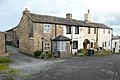
 / 53.75874; -1.79915 (6–12 Beck Hill)
6-10 Beck Hill, Buttershaw.jpg
Early 19th centuryA terrace of four cottages in sandstone with stone slate roofs. They have two storeys, doorways with plain surrounds, single-light windows in the upper floor, and two-light mullioned windows in the ground floor. [24] II
1035 and 1037 Great Horton Road
53°46′27″N1°48′17″W / 53.77428°N 1.80484°W / 53.77428; -1.80484 (1035 and 1037 Great Horton Road)
1039 and 1041 Great Horton Road, Bradford.jpg
Early 19th centuryA pair of stone cottages with a sill band and a stone slate roof. They have one storey, the doorways in the centre have squared jambs, and the windows are mullioned with two lights. [25] II
14–20 Sugden Place
53°45′32″N1°47′57″W / 53.75890°N 1.79914°W / 53.75890; -1.79914 (14–20 Sugden Place)
Early 19th centuryA pair of two-storey cottages and an attached one-storey cottage, they are in stone with stone slate roofs. The doorways are modern replacements, most of the windows are mullioned, with some mullions removed, and some modern windows have been inserted. [26] II
Crown Inn and Crown Cottage
53°46′29″N1°48′14″W / 53.77460°N 1.80395°W / 53.77460; -1.80395 (Crown Inn and Crown Cottage)
The Crown - Great Horton Road - geograph.org.uk - 603333.jpg
Early 19th centuryThe public house and cottage to the right are in sandstone, partly rendered at the front, with a stone slate roof. There are two storeys and four bays. On the front are three canted bay windows, and the upper floor contains four two-light mullioned windows. At the rear are doorways with squared jambs and mullioned windows. [27] II
67 Beck Hill, Buttershaw
53°45′32″N1°47′58″W / 53.75876°N 1.79951°W / 53.75876; -1.79951 (67 Beck Hill)
c. 1830A sandstone cottage with sill bands, block brackets to the eaves, and a stone slate roof with saddlestones and kneelers. There are two storeys and one bay. On the front is a gabled porch, and the mullions have been removed from the windows. [28] II
893 Great Horton Road
53°46′31″N1°47′58″W / 53.77519°N 1.79941°W / 53.77519; -1.79941 (893 Great Horton Road)
c. 1840–50A stone house with a moulded eaves cornice on modillion brackets and a hipped slate roof. There are two storeys, a symmetrical front of three bays, and a recessed single-bay wing on the left. The central doorway has a cornice on console brackets, and in the upper floor of the wing is a window with paired round-headed lights. [29] II
Gate Lodge and Office,
Buttershaw Mill
53°45′34″N1°47′36″W / 53.75953°N 1.79323°W / 53.75953; -1.79323 (Gate Lodge and Office, Buttershaw Mill)
Mid 19th centuryThe gate lodge and the office are both in sandstone and have bracketed eaves, hipped slate roofs, and one storey. The gate lodge has two bays, and the office is taller and longer, with seven bays. In its centre is a doorway with a segmental arch and a pediment. [30] II
Main Building, Buttershaw Mill
53°45′34″N1°47′33″W / 53.75941°N 1.79250°W / 53.75941; -1.79250 (Main Building, Buttershaw Mill)
Buttershaw Mills, Halifax Road, North Bierley - geograph.org.uk - 208558.jpg
1852The mill building is in sandstone with corbel brackets to the eaves, and a slate roof with coped gables. There are four storeys an attics, and 22  bays. At the southwest corner is a stair tower that has a belvedere with a pyramidal roof and an iron weathervane. To the right is the engine house with round-headed windows and a triangular pediment. [31] [32] II
Main block, Hill Top Primary School
53°45′19″N1°46′10″W / 53.75523°N 1.76936°W
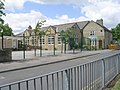
 / 53.75523; -1.76936 (Main block, Hill Top Primary School)
Hill Top Church of England Primary School - Common Road - geograph.org.uk - 1355126.jpg
c. 1880The school incorporates an earlier cottage or part of a house. The school is in sandstone with gables, and contains mullioned and transomed windows. The earlier part is in gritstone with a stone slate roof, and contains mullioned windows, and doorways with four-centred arched heads. [33] II
Ukrainian Community Memorial
53°45′34″N1°46′45″W / 53.75932°N 1.77918°W / 53.75932; -1.77918 (Ukrainian Community Memorial)
Ukrainian War Memorial - North Bierley Cemetery - Cemetery Road - geograph.org.uk - 598541.jpg
c. 1988The memorial is in the north corner of North Bierley Municipal Cemetery, and is in sandstone. It consists of an obelisk that tapers in rectangular section to a triangular top, and stands on a two-stepped base. In the upper part is a relief carving of a cross, under which are inscriptions, and an oval-shaped relief carving of the coat of arms of Ukraine surrounded by an olive wreath. [34] II

Related Research Articles

Hebden Royd is a civil parish in the metropolitan borough of Calderdale, West Yorkshire, England. It contains 254 listed buildings that are recorded in the National Heritage List for England. Of these, twelve are at Grade II*, the middle of the three grades, and the others are at Grade II, the lowest grade. The parish contains the market town of Hebden Bridge, the large village of Mytholmroyd, the valley to the south of Mytholmroyd which contains the village of Cragg Vale, and the surrounding area.

Bingley is a civil parish in the metropolitan borough of the City of Bradford, West Yorkshire, England. It contains 102 listed buildings that are recorded in the National Heritage List for England. Of these, one is listed at Grade I, the highest of the three grades, six are at Grade II*, the middle grade, and the others are at Grade II, the lowest grade. The parish contains the town of Bingley and the surrounding countryside to the north, east and south, including the villages and settlements of Cottingley, Eldwick, Gilstead, and Micklethwaite.

Burley is a civil parish in the metropolitan borough of the City of Bradford, West Yorkshire, England. It contains 55 listed buildings that are recorded in the National Heritage List for England. Of these, one is listed at Grade I, the highest of the three grades, there are none at Grade II*, the middle grade, and the others are at Grade II, the lowest grade. The parish contains the village of Burley in Wharfedale, the smaller settlement of Burley Woodhead, and the surrounding countryside. Most of the listed buildings are houses cottages and associated structures, farmhouses and farm buildings. The other listed buildings include churches and a former chapel, a former school, a former corn mill and associated structures, and a hotel.

Clayton, West Yorkshire contains the civil parish of Clayton and the ward of Clayton and Fairweather Green in the metropolitan borough of the City of Bradford, West Yorkshire, England. The parish and ward contain 68 listed buildings that are recorded in the National Heritage List for England. All the listed buildings are designated at Grade II, the lowest of the three grades, which is applied to "buildings of national importance and special interest". The parish and ward contain the village of Clayton and the surrounding area. It is largely residential, and the area to the west of the village is rural. Most of the listed buildings are houses, cottages and associated structures, farmhouses and farm buildings. The other listed buildings include two churches, a public house, a former workhouse, two schools, a village hall, and the chimney of a former factory.

Oxenhope is a civil parish in the metropolitan borough of the City of Bradford, West Yorkshire, England. It contains 44 listed buildings that are recorded in the National Heritage List for England. All the listed buildings are designated at Grade II, the lowest of the three grades, which is applied to "buildings of national importance and special interest". The parish contains the village of Oxenhope and the surrounding countryside. Most of the listed buildings are houses and cottages, farmhouses and farm buildings. The other listed buildings include a milestone, a milepost, a textile mill, a mill chimney, a public house with a mounting block nearby, churches and a chapel, and a former packhorse bridge.

Silsden is a civil parish in the metropolitan borough of the City of Bradford, West Yorkshire, England. It contains 63 listed buildings that are recorded in the National Heritage List for England. Of these, three are listed at Grade II*, the middle of the three grades, and the others are at Grade II, the lowest grade. The parish contains the town of Silsden and the surrounding countryside. Most of the listed buildings are houses, cottages and associated structures, farmhouses and farm buildings. The other listed buildings include an aqueduct for water supply and a tower involved with its construction, a canal aqueduct and warehouse, a footbridge, churches and associated structures, three milestones, and a former textile mill.

Trident is a civil parish in the metropolitan borough of the City of Bradford, West Yorkshire, England. It contains 83 listed buildings that are recorded in the National Heritage List for England. Of these, three are listed at Grade II*, the middle of the three grades, and the others are at Grade II, the lowest grade. The parish is to the south of the city of Bradford, and includes the areas of Little Horton and West Bowling. The parish is mainly residential, and includes some remnants of the textile industry. Most of the listed buildings are houses, cottages and associated structures, and the other listed buildings include churches and chapels, almshouses, a workhouse later converted into a hospital, and former textile mill buildings.

Bolton and Undercliffe is a ward in the metropolitan borough of the City of Bradford, West Yorkshire, England. It contains 20 listed buildings that are recorded in the National Heritage List for England. All the listed buildings are designated at Grade II, the lowest of the three grades, which is applied to "buildings of national importance and special interest". The ward is a suburb of Bradford to the northeast of the city centre and is almost completely residential. It includes Peel Park which contains listed buildings, including the entrance lodges, statues, drinking fountains, and a relocated doorway and wall. The other listed buildings include houses and cottages, farmhouses and farm buildings, a church, and a school.

Great Horton is a ward in the metropolitan borough of the City of Bradford, West Yorkshire, England. It contains 74 listed buildings that are recorded in the National Heritage List for England. Of these, one is listed at Grade II*, the middle of the three grades, and the others are at Grade II, the lowest grade. The ward is to the southeast of the centre of the city of Bradford and is mainly residential. Most of the listed buildings are houses and cottages and associated structures, farmhouses and farm buildings. The other listed buildings include public houses, churches and chapels, former mills, a former school, a library, and a pair of telephone kiosks.

Guiseley and Rawdon is a ward in the metropolitan borough and Rawdon is a civil parish in the City of Leeds, West Yorkshire, England. This list also contains the listed buildings in Otley and Yeadon ward. The wards and parish contain 99 listed buildings that are recorded in the National Heritage List for England. Of these, one is listed at Grade I, the highest of the three grades, three are at Grade II*, the middle grade, and the others are at Grade II, the lowest grade. The wards and parish contain the towns of Guiseley and Yeadon, the villages of Rawdon and Hawksworth, and the surrounding area. Most of the listed buildings are houses, cottages and associated structures, farmhouses and farm buildings. The other listed buildings include churches and items in churchyards, a village cross, a school, a former hospital, a railway bridge, a railway tunnel portal and retaining walls, a former tram shed, a town hall, and a telephone kiosk.

Heaton is a ward in the metropolitan borough of the City of Bradford, West Yorkshire, England. It contains 32 listed buildings that are recorded in the National Heritage List for England. Of these, four are listed at Grade II*, the middle of the three grades, and the others are at Grade II, the lowest grade. The ward is to the northwest of the centre of the city of Bradford, and contains the areas of Heaton and Frizinghall. The southern part of the ward is residential, and the northern part is rural. Most of the listed buildings are houses, cottages and associated structures, farmhouses and farm buildings. In the ward is Lister Park, which contains a listed memorial gatehouse and a memorial containing a statue. The other listed buildings include churches and a presbytery, a public house, a college, and a factory.

Idle and Thackley is a ward in the metropolitan borough of the City of Bradford, West Yorkshire, England. It contains 131 listed buildings that are recorded in the National Heritage List for England. Of these, two are listed at Grade II*, the middle of the three grades, and the others are at Grade II, the lowest grade. As well as the villages of Idle and Thackley, the ward includes the villages of Apperley Bridge and Greengates, and the surrounding area. The southern part of the ward is mainly residential, and the northern part is mainly rural. Most of the listed buildings are houses, cottages and associated structures, farmhouses and farm buildings. The other listed buildings include public houses, a church, a bridge, an archway to a former burial ground, a former toll house, a pair of locks on the Leeds and Liverpool Canal and an adjacent depot building, a war memorial, and a telephone kiosk.

Manningham is a ward in the metropolitan borough of the City of Bradford, West Yorkshire, England. It contains 76 listed buildings that are recorded in the National Heritage List for England. Of these, one is listed at Grade II*, the middle of the three grades, and the others are at Grade II, the lowest grade. The ward is to the northwest of the centre of Bradford, and is mainly residential, with some industry at the southern extremity of the ward. The listed industrial buildings are, or have been, part of the textile industry of the city. The listed residential buildings range from converted farmhouses and farm buildings, to terraces of houses and cottages, and to large villas. To the north of the ward are Bradford Grammar School, and part of Lister Park, and both contain listed buildings. The other listed buildings include churches, mosques and a synagogue, public houses, some or which have been converted for other uses, a group of almshouses and associated structures, a former police station, a hospital, schools, swimming baths, and a war memorial.

Queensbury is a village and a ward of the City of Bradford, West Yorkshire, England. The ward contains 64 listed buildings that are recorded in the National Heritage List for England. Of these, one is listed at Grade II*, the middle of the three grades, and the others are at Grade II, the lowest grade. In addition to the village of Queensbury, the ward contains the areas of Old Dolphin, Clayton Heights, and Catherine Slack and the surrounding countryside. In the ward are former textile mills, the largest being Black Dyke Mills, and some of the surviving buildings associated with these mills have been listed. Most of the other listed buildings are houses and cottages and associated structures, farmhouses and farm buildings. Otherwise, the listed buildings include churches, public houses, a pair of water troughs, milestones, a memorial to Prince Albert, a civic hall, and a war memorial.

Toller is a ward in the metropolitan borough of the City of Bradford, West Yorkshire, England. It contains 16 listed buildings that are recorded in the National Heritage List for England. Of these, one is listed at Grade II*, the middle of the three grades, and the others are at Grade II, the lowest grade. The ward is to the northwest of the centre of Bradford, and is largely residential. Most of the listed buildings are cottages in pairs, rows or blocks. The ward contains Manningham Mills, the largest mill in Bradford, which is listed at Grade II*. The other listed buildings include a lodge and a fountain associated with Chellow Dean, a large house and its entrance lodge, a former public house, a school, a group of almshouses, an archway with gates formerly leading to a house, and a church.

Tong is a ward in the metropolitan borough of the City of Bradford, West Yorkshire, England. It contains 48 listed buildings that are recorded in the National Heritage List for England. Of these, two are listed at Grade I, the highest of the three grades, five are at Grade II*, the middle grade, and the others are at Grade II, the lowest grade. The ward is southeast of the centre of Bradford and contains the district of Bierley, which is effectively a suburb of the city, the outlying villages of Tong and Holme, and surrounding areas. The village of Tong contains the two Grade I listed buildings, a large hall, and a church, both with associated listed buildings. Most of the other listed buildings are houses and cottages, farmhouses and farm buildings. The rest include a set of stocks, another church, public houses, a former school, a former cinema, a pinfold, pump, troughs and a smithy, and a war memorial.

Wyke is a ward in the metropolitan borough of the City of Bradford, West Yorkshire, England. It contains 63 listed buildings that are recorded in the National Heritage List for England. Of these, two are listed at Grade II*, the middle of the three grades, and the others are at Grade II, the lowest grade. The ward contains the village of Wyke and parts of Low Moor and Oakenshaw. It is mainly residential, with some industry, and parts of it are rural. Most of the listed buildings are houses, cottages, and associated structures, farmhouses and farm buildings. The other listed buildings include churches, public houses, buildings associated with a Moravian settlement, a former school, two milestones, a former railway station and warehouse, a chimney and boiler house, and a war memorial.

Headingley is a ward in the metropolitan borough of the City of Leeds, West Yorkshire, England. It contains 111 listed buildings that are recorded in the National Heritage List for England. Of these, two are listed at Grade II*, the middle of the three grades, and the others are at Grade II, the lowest grade. The ward is to the northwest of the centre of Leeds, and is largely residential. As Leeds became more prosperous in the 19th century, the area developed to become "the prime residential area of Leeds". Most of the listed buildings are houses and associated structures, many of the houses are large, and some were used later for other purposes. The other listed buildings include churches and associated structures, public houses, remaining structures from the Leeds Zoological and Botanical Gardens, a cinema and lamp post, a war memorial, and a group of telephone kiosks.

Rothwell is a ward in the metropolitan borough of the City of Leeds, West Yorkshire, England. It contains 40 listed buildings that are recorded in the National Heritage List for England. Of these, four are listed at Grade II*, the middle of the three grades, and the others are at Grade II, the lowest grade. In addition to the town of Rothwell, the parish contains the villages of Carlton, Oulton, and Woodlesford, and the surrounding area. Most of the listed buildings are houses and cottages, farmhouses and farm buildings. The other listed buildings include churches and a gravestone, a row of almshouses, a former poorhouse, former schools, the clock tower from a former workhouse, and a war memorial.

Stanley and Outwood East is a former ward in the metropolitan borough of the City of Wakefield, West Yorkshire, England. The former ward contains twelve listed buildings that are recorded in the National Heritage List for England. Of these, one is listed at Grade II*, the middle of the three grades, and the others are at Grade II, the lowest grade. Most of the listed buildings are houses, cottages and associated structures. There are two listed buildings constructed by the Aire and Calder Navigation Company, and the other listed building is a milepost.

References

Citations

Sources