St Bees is a civil parish in the Borough of Copeland, Cumbria, England. It contains 38 buildings that are recorded in the National Heritage List for England. Of these, four are listed at Grade I, the highest of the three grades, two are at Grade II*, the middle grade, and the others are at Grade II, the lowest grade. The parish includes the village of St Bees and the surrounding coastline and countryside. In the 12th century a Benedictine priory was established in the parish. Most of this disappeared after the Dissolution of the Monasteries apart from the priory church, most of which became the Church of St Mary and St Bega, the parish church of the village, while most of the chancel was modified for other uses. Also in the village is St Bees School, an independent school. The church, the school, and a number of associated structures are listed. Most of the other listed buildings are houses and associated structures, and farmhouses and farm buildings. The other listed buildings include a bridge, a signal box, and two war memorials.
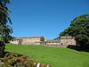
Bolton is a civil parish in the Eden District, Cumbria, England. It contains 14 buildings that are recorded in the National Heritage List for England. Of these, one is listed at Grade I, the highest of the three grades, two are at Grade II*, the middle grade, and the others are at Grade II, the lowest grade. The parish contains the village of Bolton, and is otherwise rural. The listed buildings comprise the former residence of the Bishops of Carlisle, now in ruins, a church and structures in the churchyard, houses in the village, a farmhouse and barn, a bridge, and a country house with associated structures.
Greystoke is a civil parish in the Eden District, Cumbria, England. It contains 49 listed buildings that are recorded in the National Heritage List for England. Of these, one is listed at Grade I, the highest of the three grades, five are at Grade II*, the middle grade, and the others are at Grade II, the lowest grade. The parish contains the villages of Greystoke, Little Blencow, Johnby, and Motherby, and the surrounding countryside. Three of the listed buildings originated as fortified tower houses that were later converted into country houses. Most of the listed buildings are houses and associated structures, farmhouses and farm buildings. The other listed buildings include a church and items in the churchyard, a village cross, a public house, a school, a chapel, and a bridge.
Hunsonby is a civil parish in the Eden District, Cumbria, England. It contains eight listed buildings that are recorded in the National Heritage List for England. Of these, two are listed at Grade II*, the middle of the three grades, and the others are at Grade II, the lowest grade. The parish contains the villages of Hunsonby, Little Salkeld and Winskill, and the surrounding countryside. The listed buildings comprise houses and associated structure, farmhouses, farm buildings, and a working water mill.
Hutton is a civil parish in the Eden District, Cumbria, England. It contains 13 listed buildings that are recorded in the National Heritage List for England. Of these, one is listed at Grade I, the highest of the three grades, and the others are at Grade II, the lowest grade. The parish contains the villages of Hutton and Penruddock and the surrounding countryside. The most important building in the parish is Hutton John, originally a fortified tower house and later a country house; this and associated structures are listed. Apart from a church, all the other listed buildings are houses, farmhouses and farm buildings.
Kirkby Thore is a civil parish in the Eden District, Cumbria, England. It contains 14 listed buildings that are recorded in the National Heritage List for England. Of these, two are listed at Grade II*, the middle of the three grades, and the others are at Grade II, the lowest grade. The parish contains the village of Kirkby Thore and the surrounding countryside. Most of the listed buildings are in the village, and consist of houses and associated structures, farmhouses, farm buildings, a church, a house that originated as a medieval hall, a community hall, an animal pound and an associated structure, and a structure built from Roman material. The listed buildings outside the village are a farm and associated farm buildings.
Lazonby is a civil parish in the Eden District, Cumbria, England. It contains eleven listed buildings that are recorded in the National Heritage List for England. All the listed buildings are designated at Grade II, the lowest of the three grades, which is applied to "buildings of national importance and special interest". The parish contains the village of Lazonby and the surrounding countryside. The listed buildings comprise houses, farmhouses and farm buildings, a church, a bridge, a boundary stone, a school, a railway viaduct, and a drinking trough for horses.
Long Marton is a civil parish in the Eden District, Cumbria, England. It contains 36 listed buildings that are recorded in the National Heritage List for England. Of these, one is listed at Grade I, the highest of the three grades, and the others are at Grade II, the lowest grade. The parish contains the villages of Long Marton, Brampton, and Knock, and the surrounding countryside. Most of the listed buildings are houses and associated structures, farmhouse and farm buildings. The other listed buildings include a church, a chapel, public houses, a railway goods shed and offices, and a telephone kiosk.
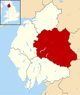
Lowther is a civil parish in the Eden District, Cumbria, England. It contains 42 listed buildings that are recorded in the National Heritage List for England. Of these, 13 are listed at Grade II*, the middle of the three grades, and the others are at Grade II, the lowest grade. The parish contains the villages of Lowther, Newtown, Hackthorpe, Melkinthorpe, and Whale. The largest building in the parish is Lowther Castle, a country house in the form of a sham castle. which is now in ruins; this and associated structures are listed. In the 1760s a model village was created, the buildings designed by Robert Adam, but was never completed; the existing buildings are all listed. Most of the other listed buildings are houses and associated structures, farmhouses and farm buildings. The other listed buildings include a church an item in the churchyard, a public house, two bridges, and a milestone.
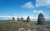
Mallerstang is a civil parish in the Eden District, Cumbria, England. It contains eight listed buildings that are recorded in the National Heritage List for England. Of these, one is listed at Grade I, the highest of the three grades, and the others are at Grade II, the lowest grade. The parish is mainly rural; it contains the village of Outhgill and the surrounding countryside and moorland. The listed buildings comprise a ruined tower house, a church, a group of three farmhouses with farm buildings, a house and its forecourt wall, and a bridge.
Martindale is a civil parish in the Eden District, Cumbria, England. It contains eleven listed buildings that are recorded in the National Heritage List for England. Of these, one is listed at Grade II*, the middle of the three grades, and the others are at Grade II, the lowest grade. The parish is in the Lake District National Park, and is sparsely populated, the only centres of habitation being the hamlets of Howtown and Sandwick; most of the parish consists of countryside, moorland and fells. The listed buildings comprise houses and associated structures, farmhouses, farm buildings, two churches and a monument in a churchyard, and two bridges.
Milburn is a civil parish in the Eden District, Cumbria, England. It contains 15 listed buildings that are recorded in the National Heritage List for England. Of these, one is listed at Grade I, the highest of the three grades, and the others are at Grade II, the lowest grade. The parish contains the village of Milburn and the surrounding countryside. The largest building in the parish is Howgill House, originally a fortified house, and later a country house; this and structures associated with it are listed. Apart from a church, all the other listed buildings are located in the village and are centred round The Green.
Murton is a civil parish in the Eden District, Cumbria, England. It contains eleven listed buildings that are recorded in the National Heritage List for England. Of these, two are listed at Grade II*, the middle of the three grades, and the others are at Grade II, the lowest grade. The parish contains the villages of Murton and Hilton and the hamlet of Brackenber, and is otherwise rural. Most of the listed buildings are houses and associated structures, farmhouses and farm buildings, the other buildings consisting of two village pumps, a bridge, and a disused railway viaduct.
Orton is a civil parish in the Eden District, Cumbria, England. It contains 15 listed buildings that are recorded in the National Heritage List for England. Of these, two are listed at Grade II*, the middle of the three grades, and the others are at Grade II, the lowest grade. The parish contains the village of Orton, and smaller settlements including Kelleth, Raisbeck, and Greenholme, but is almost completely rural. Most of the listed buildings are houses and associated structures, farmhouses and farm buildings. The other listed buildings are a church, a packhorse bridge, a marker stone, and two former schools.
Ravenstonedale is a civil parish in the Eden District, Cumbria, England. It contains 60 listed buildings that are recorded in the National Heritage List for England. Of these, one is listed at Grade I, the highest of the three grades, two are at Grade II*, the middle grade, and the others are at Grade II, the lowest grade. The parish contains the villages of Ravenstonedale and Newbiggin-on-Lune and is otherwise rural. Most of the listed buildings are houses and associated structures, farmhouses and farm buildings. The other listed buildings include a church and items in the churchyard, chapels and associated structures, a public house, bridges, and milestones.
Skelton is a civil parish in the Eden District, Cumbria, England. It contains 56 listed buildings that are recorded in the National Heritage List for England. Of these, three are listed at Grade I, the highest of the three grades, three are at Grade II*, the middle grade, and the others are at Grade II, the lowest grade. The parish is mainly rural, and contains a number of villages and smaller settlements, including Skelton, Ellonby, Lamonby, Unthank, Unthank End, Laithes, and Ivegill. Most of the listed buildings are country houses and smaller houses with associated structures, farmhouses and farm buildings. The other listed buildings include churches and structures in the churchyards, a chapel, a bridge, a boundary stone, and a war memorial lych gate.
Winton is a civil parish in the Eden District, Cumbria, England. It contains twelve listed buildings that are recorded in the National Heritage List for England. Of these, one is listed at Grade II*, the middle of the three grades, and the others are at Grade II, the lowest grade. The parish includes the village of Winton, and is otherwise rural. The listed buildings consist of houses and associated structures, farmhouses and farm buildings, and a pinfold, a boundary stone, and a former school.
Yanwath and Eamont Bridge is a civil parish in the Eden District, Cumbria, England. It contains 15 listed buildings that are recorded in the National Heritage List for England. Of these, three are listed at Grade I, the highest of the three grades, one is at Grade II*, the middle grade, and the others are at Grade II, the lowest grade. The parish contains the villages of Yanwath and Eamont Bridge, and the surrounding countryside. The listed buildings consist of a tower house and associated structures, a road bridge, which is also a scheduled monument, a railway viaduct, houses and associated structures, a hotel, a public house, a farmhouse and farm buildings.
Claife is a civil parish in the South Lakeland District of Cumbria, England. It contains 45 listed buildings that are recorded in the National Heritage List for England. Of these, four are listed at Grade II*, the middle of the three grades, and the others are at Grade II, the lowest grade. The parish is in the Lake District National Park to the west of Windermere. It contains the villages and settlements of Far Sawrey, Near Sawrey, Colthouse, Loanthwaite, High Wray and Low Wray, and the surrounding countryside. Most of the listed buildings are farmhouses, farm buildings, and houses with associated structures. The other listed buildings include churches, a public house, and a bridge.
Ashton-under-Lyne is a town in the Tameside, Greater Manchester, England. The town and the countryside to the north contain 51 listed buildings that are recorded in the National Heritage List for England. Of these, one is listed at Grade I, the highest of the three grades, seven are at Grade II*, the middle grade, and the others are at Grade II, the lowest grade.