Listed buildings in Mickleover

Last updated

Mickleover is an electoral ward in the city of Derby, England. The ward contains 13 listed buildings that are recorded in the National Heritage List for England. Of these, two are listed at Grade II*, the middle of the three grades, and the others are at Grade II, the lowest grade. The ward contains the village of Mickleover, later a suburb of the city, to the southwest of its centre. All the listed buildings are near the centre of the village, and consist of houses and cottages with associated structures, a church and a war memorial.

Contents

Key

Map all coordinates using: OpenStreetMap  
Download coordinates as: KML
GradeCriteria [1]
II*Particularly important buildings of more than special interest
IIBuildings of national importance and special interest

Buildings

Name and locationPhotographDateNotesGrade
All Saints' Church
52°54′16″N1°32′51″W / 52.90444°N 1.54761°W
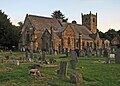
 / 52.90444; -1.54761 (All Saints' Church)
Mickleover- All Saints Church and churchyard (geograph 4536716).jpg
Early 14th centuryThe church has been altered and extended through the centuries, and it was damaged by fire in 1767. Alterations were made in 1858–59 by H. I. Stevens, and additions were made in 1965–67. It is built in stone with a slate roof, and consists of a nave, north and south aisles, a south porch, a chancel, a vestry and a north aisle chapel, and a west tower. The tower has angle buttresses, and an embattled parapet with corner pinnacles. [2] [3] II*
4 The Hollow
52°54′11″N1°32′40″W / 52.90317°N 1.54437°W / 52.90317; -1.54437 (4 The Hollow)
4 The Hollow, Mickleover.jpg
14th centuryThe house is timber framed with red brick nogging, the exterior dating from the late 16th to early 17th century. It has a deep stone base, a tile roof, two storeys and an attic. The doorway has a plain surround and a modern porch, the windows are casements, and there are two gabled dormers. [4] [5] II
1 and 2 The Hollow
52°54′13″N1°32′42″W / 52.90352°N 1.54506°W / 52.90352; -1.54506 (1 and 2 The Hollow)
1 and 2 The Hollow, Mickleover.jpg
Late 14th centuryA pair of houses, No. 2 containing internal fabric dating from the 14th and 16th centuries, and the exterior of both houses dating from the late 18th to early 19th centuries. The exterior is in red brick on a rendered plinth, with stone dressings and a blue tile roof. There are two storeys and each house has two bays. No. 1 has a doorway with a timber gabled hood, pilasters and a rectangular fanlight. It is flanked by tripartite sash windows with segmental-arched heads, and the upper floor contains three sash windows under a dog-tooth eaves course. The doorway of No. 2 has pilasters and a cornice, it is flanked by three-light horizontally-sliding sash windows, above are two sash windows, and all the windows have deep lintels. [6] II
Old Hall
52°54′10″N1°32′51″W / 52.90284°N 1.54755°W / 52.90284; -1.54755 (Old Hall)
Old Hall, Orchard Street - geograph.org.uk - 80308.jpg
1649The house is timber framed with red brick nogging, on a stone plinth, and the roof is tiled. There are two storeys and an attic, and a double pile plan. In the centre of the front is a two-storey gabled porch, the upper floor jettied. The sides are open, with balusters, and on the bressummer is an inscription. The windows are mullioned, with three cast iron lattice lights. [2] [7] II*
Gate piers, Old Hall
52°54′10″N1°32′51″W / 52.90286°N 1.54742°W / 52.90286; -1.54742 (Gate piers, Old Hall)
Late 17th centuryThe gate piers are in stone, and have consoles with heavy cornices and large ball finials. [8] II
The Gables
52°54′14″N1°32′43″W / 52.90376°N 1.54515°W / 52.90376; -1.54515 (The Gables)
The Gables, Mickleover.jpg
17th or 18th centuryThe house is in red brick with floor bands and a tile roof. There are two storeys and attics, four bays, and a single-story extension on the right. On the front are two gables with decorative bargeboards, and two gabled porches with plain doorways. Some of the windows are 19th-century casements and others are replacements. [9] II
11 Limes Avenue
52°54′13″N1°32′38″W / 52.90369°N 1.54380°W / 52.90369; -1.54380 (11 Limes Avenue)
18th centuryThe house, which may have an earlier core, is in red brick on a stone plinth, with a floor band, sprocket eaves and a tile roof. There are two storeys and three bays. The doorway and the windows, which are casements, have segmental heads. [10] II
Manor Farmhouse
52°54′17″N1°32′46″W / 52.90486°N 1.54605°W / 52.90486; -1.54605 (Manor Farmhouse)
Manor Farmhouse, Mickleover.jpg
Late 18th or early 19th centuryThe farmhouse, which probably has an earlier core, is in red brick with plain eaves and a tile roof. There are two storeys and five bays, and the gable end faces the road. The central doorway has pilasters, a rectangular fanlight and a cornice hood, and the windows are small-paned with cast iron frames and opening lights. [11] II
13–18 The Green
52°54′11″N1°32′48″W / 52.90294°N 1.54668°W
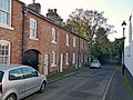
 / 52.90294; -1.54668 (13–18 The Green)
13-18 The Green, Mickleover.jpg
Early 19th centuryA row of cottages in red brick with dog-tooth eaves and a slate roof. There are two storeys and each cottage has one bay. The doorways and most of the windows, which are a mix of sashes and casements, have cambered heads. Between Nos. 13 and 14 is an archway with a segmental-arched head. [12] II
5–8 The Hollow
52°54′11″N1°32′39″W / 52.90296°N 1.54412°W
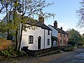
 / 52.90296; -1.54412 (5–8 The Hollow)
5-8 The Hollow, Mickleover.jpg
Early 19th centuryA range of cottages in two blocks. They are in red brick, partly painted, with modillion eaves, and roofs of tile and slate. There are two storeys, and the blocks are joined by a brick segmental arch. The doorway in the left block has a round-arched head and a semicircular fanlight, and in the right block are two doorways with segmental heads, one blocked. The windows are a mix of casements, and horizontally-sliding sashes, those in the ground floor with segmental heads. [13] II
The Limes
52°54′12″N1°32′31″W / 52.90325°N 1.54185°W / 52.90325; -1.54185 (The Limes)
The Limes, Mickleover.jpg
Early 19th centuryA large stuccoed house with corner pilasters, a floor band, overhanging eaves, and a hipped slate roof. There are two storeys, and fronts of five bays. On the entrance front is a porch with Doric columns, angle piers, and an [entablature]], and in the centre of the garden front is a two-storey bow window. The windows are sashes. [2] [14] II
Mickleover Manor
52°54′15″N1°32′56″W / 52.90420°N 1.54890°W / 52.90420; -1.54890 (Mickleover Manor)
Mickleover Manor.jpg
1849A large house designed by Henry Duesbury in Tudor style, it was enlarged in 1862, and later used as a school and a hospital, before being divided into flats. The house is in red brick with stone dressings, floor bands, and a tile roof with coped gables and obelisk finials. There are two storeys and attics, and a four-stage tower with a stone cornice and an embattled parapet. The windows are mullioned, and most also have transoms and hood moulds. [2] [15] II
War memorial
52°54′14″N1°32′49″W / 52.90395°N 1.54697°W / 52.90395; -1.54697 (War memorial)
Mickleover War Memorial.jpg
1920The war memorial is in the churchyard of All Saints' Church and is in Hopton Wood limestone. It is in the form of a Latin cross, with a tapering shaft on a trapezoidal plinth that has a moulded top, on a base of two steps. On the plinth are bronze plaques with inscriptions and the names of those lost in the two World Wars. [16] II


Related Research Articles

Ault Hucknall is a civil parish in the Bolsover district of Derbyshire, England. The parish contains 23 listed buildings that are recorded in the National Heritage List for England. Of these, three are listed at Grade I, the highest of the three grades, one is at Grade II*, the middle grade, and the others are at Grade II, the lowest grade. The parish contains the village of Ault Hucknall and the surrounding area, including the settlements of Astwith, Hardstoft, and Rowthorne. The most important buildings in the parish are Hardwick Hall and its predecessor Hardwick Old Hall, which are listed together with associated structures in the grounds and surrounding parkland. The other listed buildings include a church and a chest tomb in the churchyard, houses and farmhouses, a public house, a watermill, a former Sunday school, and a war memorial.

Cauldwell is a civil parish in the South Derbyshire district of Derbyshire, England. The parish contains four listed buildings that are recorded in the National Heritage List for England. Of these, one is listed at Grade II*, the middle of the three grades, and the others are at Grade II, the lowest grade. The parish contains the village of Cauldwell and the surrounding area. The listed buildings consist of a church, a small country house, and two farmhouses.

Clowne is a civil parish in the Bolsover District of Derbyshire, England. The parish contains nine listed buildings that are recorded in the National Heritage List for England. Of these, two are listed at Grade II*, the middle of the three grades, and the others are at Grade II, the lowest grade. The parish contains the town of Clowne and the surrounding area. The listed buildings consist of houses and associated structures, the ruins of a former country house, a church, a market cross, and a war memorial.

Great Longstone is a civil parish in the Derbyshire Dales district of Derbyshire, England. The parish contains 31 listed buildings that are recorded in the National Heritage List for England. Of these, one is listed at Grade I, the highest of the three grades, one is at Grade II*, the middle grade, and the others are at Grade II, the lowest grade. The parish contains the village of Great Longstone and the surrounding area. Most of the listed buildings are houses, cottages and farmhouses and associated structures. Part of the gardens of Thornbridge Hall are in the parish, and these contain a number of listed buildings. The other listed buildings include a church, a cross in the churchyard, the village cross, two public houses, a former guidepost used as a gatepost, a former railway station, a war memorial, and a telephone kiosk.

Kilburn is a civil parish in the Amber Valley district of Derbyshire, England. The parish contains four listed buildings that are recorded in the National Heritage List for England. Of these, one is listed at Grade II*, the middle of the three grades, and the others are at Grade II, the lowest grade. The parish contains the village of Kilburn and the surrounding area. All the listed buildings are in the village, and consist of a house, a farmhouse, farm buildings, and a war memorial.

South Darley is a civil parish in the Derbyshire Dales district of Derbyshire, England. The parish contains nine listed buildings that are recorded in the National Heritage List for England. Of these, one is listed at Grade I, the highest of the three grades, and the others are at Grade II, the lowest grade. The parish contains the villages of Darley Bridge, Snitterton and Wensley, and the surrounding countryside. The listed buildings consist of houses and associated structures, a public house, a church, a milestone and a telephone kiosk.

Whitwell is a civil parish in the Bolsover District of Derbyshire, England. The parish contains 15 listed buildings that are recorded in the National Heritage List for England. Of these, two are listed at Grade I, the highest of the three grades, one is at Grade II*, the middle grade, and the others are at Grade II, the lowest grade. The parish contains the village of Whitwell and the surrounding area. The listed buildings include churches, houses, farmhouses and farm buildings, a public house, a village pump, and a war memorial.

Wirksworth is a civil parish in the Derbyshire Dales district of Derbyshire, England. The parish contains 107 listed buildings that are recorded in the National Heritage List for England. Of these, one is listed at Grade I, the highest of the three grades, nine are at Grade II*, the middle grade, and the others are at Grade II, the lowest grade. The parish contains the market town of Wirksworth and the surrounding countryside. Most of the listed buildings are houses and associated structures, shops, farmhouses and farm buildings. The other listed buildings include a church and associated structures, public houses, a cotton spinning mill and associated structures, mileposts and milestones, a cemetery chapel, a railway bridge, groups of bollards, schools, a former engine house, a war memorial and a telephone kiosk.

Woodville is a civil parish in the South Derbyshire district of Derbyshire, England. The parish contains four listed buildings that are recorded in the National Heritage List for England. All the listed buildings are designated at Grade II, the lowest of the three grades, which is applied to "buildings of national importance and special interest". The parish contains the village of Woodville, and the listed buildings consist of a church, a war memorial, and buildings surviving from closed pottery works.

Wormhill is a civil parish in the High Peak district of Derbyshire, England. The parish contains 26 listed buildings that are recorded in the National Heritage List for England. Of these, three are listed at Grade II*, the middle of the three grades, and the others are at Grade II, the lowest grade. The parish contains the village of Wormhill and the surrounding area. Most of the listed buildings are houses, cottages and associated structures, farmhouses and farm buildings. The other listed buildings include a church and associated structures, a village cross moved into the churchyard, a railway viaduct, and a memorial fountain.

Yeaveley is a civil parish in the Derbyshire Dales district of Derbyshire, England. The parish contains nine listed buildings that are recorded in the National Heritage List for England. Of these, one is listed at Grade I, the highest of the three grades, one is at Grade II*, the middle grade, and the others are at Grade II, the lowest grade. The parish contains the village of Yeaveley and the surrounding countryside. The oldest listed building in the parish consists of the remains of a preceptory of the Knights Hospitaller. The other listed buildings are houses and associated structures, farmhouses and farm buildings, and a church.

Yeldersley is a civil parish in the Derbyshire Dales district of Derbyshire, England. The parish contains 14 listed buildings that are recorded in the National Heritage List for England. All the listed buildings are designated at Grade II, the lowest of the three grades, which is applied to "buildings of national importance and special interest". The parish is almost entirely rural, with no substantial settlements, and the listed buildings consist of houses, cottages and associated structures, farmhouses and farm buildings, and a milepost.

Abbey is an electoral ward in the city of Derby, England. The ward contains 15 listed buildings that are recorded in the National Heritage List for England. Of these, one is listed at Grade II*, the middle of the three grades, and the others are at Grade II, the lowest grade. The ward, which is to the west of the city centre, is mainly residential. The listed buildings include a public house, a former toll house, private houses later used for other purposes, the lodge to a cemetery and three memorials in the cemetery, a former training college, former barracks, a church and associated structures, and an engine house and a warehouse built by the Great Northern Railway.

Alvaston is an electoral ward in the city of Derby, England. The ward contains 14 listed buildings that are recorded in the National Heritage List for England. Of these, three are listed at Grade II*, the middle of the three grades, and the others are at Grade II, the lowest grade. The ward was initially a village, and it has grown to become a suburb of the city. Towards the north of the ward are the former Tri Junct Station and the Derby Railway Works, and associated with them are four listed buildings. Some of the oldest listed buildings, consisting of cottages and a farmhouse, are located near the original centre of the village. The other listed buildings include churches and associated structures, a former toll house, and a conference centre.

Arboretum is an electoral ward in the city of Derby, England. The ward contains over 150 listed buildings that are recorded in the National Heritage List for England. Of these, three are listed at Grade I, the highest of the three grades, 12 are at Grade II*, the middle grade, and the others are at Grade II, the lowest grade. The ward contains the centre of the city and an area to the south, including Rose Hill. Most of the listed buildings are houses and associated structures, shops, offices, public buildings, banks, public houses and hotels. In the area near the railway stations is accommodation built for railway workers, now listed, and to the south of the centre is Derby Arboretum, which contains a variety of listed buildings. The other listed buildings include Derby Cathedral, churches and associated structures, a former grammar school, a set of wrought iron gates by Robert Bakewell, bollards, a group of almshouses, a railway bridge, a market hall, a photographic studio, statues, a museum, a former theatre and war memorials.

Boulton is an electoral ward in the city of Derby, England. The ward contains four listed buildings that are recorded in the National Heritage List for England. Of these, one is listed at Grade II*, the middle of the three grades, and the others are at Grade II, the lowest grade. The ward is a suburb of Derby to the southeast of its centre, and is largely residential. The listed buildings consist of a church, two houses, and stables and outbuildings.

Chaddesden is an electoral ward in the city of Derby, England. The ward contains three listed buildings that are recorded in the National Heritage List for England. Of these, one is listed at Grade I, the highest of the three grades, and the others are at Grade II, the lowest grade. The ward is a suburb to the east of the centre of the city and is largely residential. The listed buildings consist of a church, a cottage and a war memorial.

Chellaston is an electoral ward in the city of Derby, England. The ward contains seven listed buildings that are recorded in the National Heritage List for England. Of these, one is listed at Grade II*, the middle of the three grades, and the others are at Grade II, the lowest grade. The ward contains a suburban village to the south of the city centre, and it is mainly residential. The listed buildings consist of a church, houses and a cottage, a farmhouse and farm buildings, and a war memorial.

Derwent is an electoral ward in the city of Derby, England. The ward contains four listed buildings that are recorded in the National Heritage List for England. All the listed buildings are designated at Grade II, the lowest of the three grades, which is applied to "buildings of national importance and special interest". The ward is to the northeast of the centre of the city, and the listed buildings consist of a bridge, buildings at the entrance to Nottingham Road Cemetery, a war memorial in thea cemetery, and an office block.

Littleover is an electoral ward in the city of Derby, England. The ward contains eleven listed buildings that are recorded in the National Heritage List for England. All the listed buildings are designated at Grade II, the lowest of the three grades, which is applied to "buildings of national importance and special interest". The ward contains the former village of Littleover, which is now a suburb to the southwest of the centre of Derby. The listed buildings consist of houses and cottages, a church, a country house converted into a school, a horse trough, and a war memorial.

References

Citations

Sources

  • Historic England, "Church of All Saints, Mickleover (1216184)", National Heritage List for England , retrieved 31 January 2023
  • Historic England, "4 The Hollow, Mickleover (1287489)", National Heritage List for England, retrieved 31 January 2023
  • Historic England, "1 and 2 The Hollow, Mickleover (1228195)", National Heritage List for England, retrieved 31 January 2023
  • Historic England, "Old Hall, Mickleover (1279400)", National Heritage List for England, retrieved 31 January 2023
  • Historic England, "Gatepiers at No. 5 (Old Hall), Mickleover (1228878)", National Heritage List for England, retrieved 31 January 2023
  • Historic England, "The Gables, Mickleover (1229588)", National Heritage List for England, retrieved 1 February 2023
  • Historic England, "11 Limes Avenue, Mickleover (1228466)", National Heritage List for England, retrieved 31 January 2023
  • Historic England, "Manor Farmhouse, Mickleover (1229849)", National Heritage List for England, retrieved 31 January 2023
  • Historic England, "13–18 The Green, Mickleover (1216587)", National Heritage List for England, retrieved 31 January 2023
  • Historic England, "5–8 The Hollow, Mickleover (1228203)", National Heritage List for England, retrieved 31 January 2023
  • Historic England, "The Limes, Mickleover (1228289)", National Heritage List for England, retrieved 1 February 2023
  • Historic England, "Mickleover Manor, Mickleover (1216268)", National Heritage List for England, retrieved 31 January 2023
  • Historic England, "Mickleover War Memorial, Mickleover (1431898)", National Heritage List for England, retrieved 1 February 2023
  • Hartwell, Clare; Pevsner, Nikolaus; Williamson, Elizabeth (2016) [1978]. Derbyshire. The Buildings of England. New Haven and London: Yale University Press. ISBN   978-0-300-21559-5.
  • Historic England, Listed Buildings , retrieved 31 January 2023