Daresbury is a village and civil parish in the Borough of Halton, Cheshire, England. At the 2011 census, it had a population of 246.
Preston Brook is a village and civil parish in the borough of Halton, a unitary authority in the ceremonial county of Cheshire in North West England. It is located to the south-east of Runcorn and south-west of Warrington, adjacent to the M56 motorway. The parish includes the village of Preston on the Hill.

Runcorn is an industrial town in Halton, Cheshire, England, on the south bank of the River Mersey where it narrows at Runcorn Gap. In the town are the 61 buildings that are recorded in the National Heritage List for England as designated listed buildings in the current urban area of Runcorn, including the districts of Runcorn, Halton, Weston, Weston Point, and Norton. Two of these are classified as being in Grade I, nine in Grade II*, and 51 in Grade II.

All Saints' Church is in the village of Daresbury, Cheshire, England. It is known for its association with Lewis Carroll who is commemorated in its stained glass windows depicting characters from Alice's Adventures in Wonderland. It is recorded in the National Heritage List for England as a designated Grade II* listed building. The church is an active Church of England parish church in the diocese of Chester, the archdeaconry of Chester and the deanery of Great Budworth. The author Lewis Carroll was born in All Saints' Vicarage in 1832 when his father, Charles Dodgson, was perpetual curate at the church. This was commemorated in March 2012 when the Lewis Carroll Centre, attached to the church, was opened.

Widnes is an industrial town in the Borough of Halton, Cheshire, England, on the north bank of the River Mersey where it narrows at Runcorn Gap. The town contains 24 buildings that are recorded in the National Heritage List for England as designated listed buildings. Of these, 5 are classified at Grade II*, and the rest are at Grade II; Widnes has no Grade I listed buildings. In the United Kingdom, the term "listed building" refers to a building or other structure officially designated as being of special architectural, historical, or cultural significance. Listed buildings are categorised in three grades: Grade I consists of buildings of outstanding architectural or historical interest; Grade II* includes particularly significant buildings of more than local interest; Grade II consists of buildings of special architectural or historical interest. Buildings in England are listed by the Secretary of State for Culture, Media and Sport on recommendations provided by English Heritage, which also determines the grading.
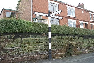
Preston on the Hill is a village and former civil parish, now in the parish of Preston Brook and the unitary authority area of Halton, in Cheshire, England. It is between the villages of Daresbury 1.5 miles (2.4 km) to the north and Dutton 1.1 miles (1.8 km) to the south. The village comprises the hamlets of Windmill Lane, Waterfront, Cotton's Bridge, Tunnel End North, Tunnel Top and Barker's Hollow as well as several farms including White House, Little Manor, New Manor, Windmill Farm and Humble Bee House.

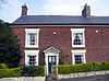
Bridgewater House is in the Old Coach Road, Runcorn, Cheshire, England. It is recorded in the National Heritage List for England as a designated Grade II listed building. Originally built for the use of the Duke of Bridgewater, it has since has been used for various purposes and has now been converted into offices.

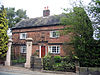
Daresbury Hall is a former Georgian country house in the village of Daresbury, Cheshire, England. It was built in 1759 for George Heron. The house is recorded in the National Heritage List for England as a designated Grade II* listed building. The mansion was badly damaged by fire in 2016.

In the English civil parish of Lymm, there are 55 buildings that are recorded in the National Heritage List for England as designated listed buildings. Of these, one is classified as Grade I and one as Grade II*; the remainder are at Grade II. Lymm is in the borough of Warrington and the ceremonial county of Cheshire. In the early 16th century, the civil parish was a prosperous agricultural area, divided into two manors, Lymm and Oughtrington. The Grade-II*-listed Lymm Hall, the oldest listed building in the civil parish, dates from the late 16th century and occupies the site of a medieval building which was the manorial seat. The largest settlement in the civil parish is Lymm, which has expanded into a small town whilst retaining its village centre. Several other small settlements within the parish remain separate, including Oughtrington; Oughtrington Hall dates from around 1810.
Helsby is a village and a civil parish in Cheshire West and Chester, England. The A56 road passes through it in a north–south direction. To the east is the former Helsby hill fort and to the west are the Manchester Ship Canal and the River Mersey. Helsby contains 13 buildings that are recorded in the National Heritage List for England as designated listed buildings, all of which are at Grade II. This grade is the lowest of the three gradings given to listed buildings and is applied to "buildings of national importance and special interest".
Aston-by-Sutton is a civil parish in Cheshire West and Chester, England. It is largely rural, with the West Coast Main Line and the Trent and Mersey Canal passing through its east border, and the River Weaver running to the south. The parish contains 30 buildings that are recorded in the National Heritage List for England as designated listed buildings. Of these, one is listed at Grade I, St Peter's Church, and the others at Grade II. Of the latter, there are a number of tombs and other structures associated with the church. The other listed buildings include houses, a war memorial, buildings associated with the former Aston Old Hall, and structures related to the canal.
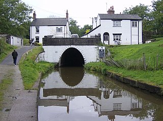
Dutton is a civil parish in Cheshire West and Chester, England. It contains the village of Dutton, but is otherwise rural. Important transport links pass through the parish. The West Coast Main Line runs through in a north–south direction. Dutton Viaduct and the Weaver Junction are in the parish. The Trent and Mersey Canal runs through it in a northwest–southeast direction, and enters the south portal of the Preston Brook Tunnel. The A533 road traverses the parish in a similar direction. In the southern part of the parish, running east–west, is the River Weaver and the Weaver Navigation. Included in the parish are 22 buildings that are recorded in the National Heritage List for England as designated listed buildings. Some of the buildings are houses, and others are associated with the Trent and Mersey Canal and the Weaver Navigation.
Little Leigh is a civil parish in Cheshire West and Chester, England. Other than the village of Little Leigh, the parish is entirely rural. It contains eleven buildings that are recorded in the National Heritage List for England as designated listed buildings, all of which are at Grade II. This grade is the lowest of the three gradings given to listed buildings and is applied to "buildings of national importance and special interest". The A49 road runs to the west of the parish, the A533 road to the northeast, and the River Weaver to the south. Traversing the parish is the Trent and Mersey Canal. Four of the listed buildings are associated with the canal: two bridges, an aqueduct, and a milepost. The other listed buildings consist of a former farmhouse, now a public house, with two of its associated buildings, another farmhouse, a cottage, and a church with its lychgate.
Northwich is a civil parish and a town in Cheshire West and Chester, England. It contains 35 buildings that are recorded in the National Heritage List for England as designated listed buildings. Two of these are listed at Grade I, the highest grade, and the rest at the lowest grade, Grade II; none are listed at the middle grade, Grade II*. The River Dane joins the River Weaver and the Weaver Navigation within the parish. Also passing through the parish are the A533 road, the Trent and Mersey Canal, and a railway built by the Cheshire Lines Committee. Many of the listed buildings are associated with these features.
Barnton is a village and a civil parish in Cheshire West and Chester, England. It contains 11 buildings that are recorded in the National Heritage List for England as designated listed buildings, all of which are at Grade II. This grade is the lowest of the three gradings given to listed buildings and is applied to "buildings of national importance and special interest". Running through the parish are the Trent and Mersey Canal, which passes through two tunnels, and the River Weaver together with the Weaver Navigation. The majority of the listed buildings in the parish are associated with these transport links. Associated with the canal are four tunnel entrances, an airshaft, two mileposts, and a terrace of cottages. The Weaver Navigation contains Saltersford Locks, and its toll house. The other listed building is the village church, Christ Church.
Anderton with Marbury is a civil parish in Cheshire West and Chester, England, which contains the villages of Anderton and Marbury. The Trent and Mersey Canal runs through the parish. Also in the parish is the Anderton Boat Lift, a scheduled monument, which has been restored to carry boats from the canal down to the Weaver Navigation. In the parish are four buildings that are recorded in the National Heritage List for England as designated listed buildings, all of which are at Grade II. This grade is the lowest of the three gradings given to listed buildings and is applied to "buildings of national importance and special interest". The structures consist of a mill and the miller's house, a farmhouse, and a milepost on the canal.
There are over 9,000 Grade I listed buildings and 20,000 Grade II* listed buildings in England. This page is a list of these buildings in the borough of Halton in Cheshire.
Betchton is a civil parish in Cheshire East, England. It contains 18 buildings that are recorded in the National Heritage List for England as designated listed buildings. Of these, one is listed at Grade II*, the middle grade, and the others are at Grade II. The parish is almost entirely rural. Many of the listed buildings are timber-framed farmhouses dating from the 16th and 17th centuries. The Trent and Mersey Canal runs through the parish, and eight structures associated with this are listed, namely four bridges, two locks, and two mileposts. The other listed buildings are structures associated with the farmhouses, a country house, and a public house.
Worsley is a town in the City of Salford Metropolitan Borough, Greater Manchester, England. The town, together with the areas of Walkden and Little Hulton, contains 56 listed buildings that are recorded in the National Heritage List for England. Of these, two are listed at Grade I, the highest of the three grades, and the others are at Grade II, the lowest grade.
Stretford is a town in the Metropolitan Borough of Trafford, Greater Manchester, England. The town contains 20 listed buildings that are recorded in the National Heritage List for England. All the listed buildings are designated at Grade II, the lowest of the three grades, which is applied to "buildings of national importance and special interest". The town is adjacent to the centre of Manchester, and is partly residential and partly industrial. The Bridgewater Canal and the Manchester Ship Canal run through the town, and there are listed buildings associated with both canals. The other listed buildings include two medieval structures, churches, the entrances to a former botanical garden and to a park, a factory, civic buildings, a former cinema, a hotel, and three war memorials.