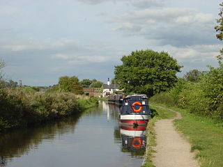
Shardlow

Last updated • 8 min readFrom Wikipedia, The Free Encyclopedia

Shardlow
Shardlpw Canal.JPG
Main wharf, Shardlow
Derbyshire UK location map.svg
Red pog.svg
Shardlow
Location within Derbyshire
OS grid reference SK437302
Civil parish
District
Shire county
Region
Country England
Sovereign state United Kingdom
Post town DERBY
Postcode district DE72
Police Derbyshire
Fire Derbyshire
Ambulance East Midlands
UK Parliament
List of places
UK
England
Derbyshire
52°52′12″N1°21′29″W / 52.870°N 1.358°W / 52.870; -1.358

Shardlow is a village in Derbyshire, England about 6 miles (9.7 km) southeast of Derby and 11 miles (18 km) southwest of Nottingham. Part of the civil parish of Shardlow and Great Wilne, and the district of South Derbyshire, it is also very close to the border with Leicestershire, defined by the route of the River Trent which passes close to the south. Just across the Trent is the Castle Donington parish of North West Leicestershire.

Contents

An important late 18th-century river port for the trans-shipment of goods to and from the River Trent to the Trent and Mersey Canal, [1] during its heyday from the 1770s to the 1840s it became referred to as "Rural Rotterdam" and "Little Liverpool". [2] Today Shardlow is considered Britain's most complete surviving example of a canal village, [2] with over 50 Grade II listed buildings and many surviving public houses within the designated Shardlow Wharf Conservation Area. [1] [2]

History

Due to its location on the River Trent, which up to this point is easily navigable, there is much early evidence of human activity in the area, dating back to 1500 BC. In 1999 the 12-foot-long (3.7 m) 1300 BC Hanson Log Boat, a Bronze Age log boat was discovered at the nearby Hanson plc gravel pit. Sawn into sections so that it could be transported and conserved, the boat is now in Derby Museum and Art Gallery. [3] Five years later, a JCB in the quarry unearthed a bronze sword embedded in a vertical position in the gravel. [2] There is also a Stone Age tumulus at Lockington, an Iron Age settlement between Shardlow/Wilne and the river, and later Roman finds at Great Wilne. [1]

In 1009 Æþelræd Unræd (King Ethelred the Unready) signed a charter at the Great Council which recognised the position and boundaries of Westune. [4] The land described in that charter included the lands now known as Shardlow, Great Wilne, Church Wilne, Crich, Smalley, Morley, Weston and Aston-on-Trent. Under this charter Æþelræd gave his minister a number of rights that made him free from tax and to his own rule within the manor. [5] The manor of Shardlowe was the subject of a land deal in 1413. [6]

The village is listed as Serdelau in the Domesday Book [2] - translated as a settlement near a mound with a notch or indentation – but there have been up to 20 different spellings noted by historians. [2] The oldest surviving building today in the village is believed to be the "Dog & Duck" public house, located in the upper end of the village. [2]

Transport hub

An old barn, built for storing grain before the arrival of the canal Old Barn Shardlow.JPG
An old barn, built for storing grain before the arrival of the canal

The River Trent below Shardlow is navigable all the way to the Humber Estuary, as is the River Soar which joins 2 miles (3.2 km) further downstream. Resultantly Shardlow was always an important transport hub and trading point, as wide-beam ships and boats traded cargo commercially with the packhorse trails going across the region. [1] The tariffs charged for goods proceeding through the port enabled industrialist Leonard Fosbrooke to build Shardlow Hall, [2] and later led to skirmishes being fought locally during the English Civil War for control of the strategic transport hub. [2]

The original London to Manchester road (formerly an important turnpike road, authorised in 1738, and now the A6), passes through the village, having crossed the Trent at Cavendish Bridge, designed by the Duke of Devonshire's architect, James Paine. [2] By 1310 a rope-hauled ferry boat had replaced the last of a series of medieval bridges that crossed the Trent at what was known as Wilden Ferry. Later archaeological investigations in the Hemington Fields quarry revealed that the three wooden bridges were destroyed by floods between 1140 and 1309. During this period the unstable gravel bed of the Trent was affected by a succession of large floods, which meant that the river shifted its course significantly during this time, demolishing the bridges and an adjacent Norman mill weir. [7]

The charge to cross Paine's original 1758–1761 bridge during the years when it was subject to tolls was 2s 6d (12.5p) for carriages. It survived in service until 1947, when the Trent, swollen by a rapid thaw, swept its supports away. The British Army provided a temporary Bailey bridge, which was replaced by the present structure in 1957. Today the pediment of Paine's bridge survives as a preserved structure, with the toll charges engraved into it. [2]

Port

The oldest surviving warehouse in Shardlow, formerly the old Salt warehouse, built in the 1770s. Today owned by the Mansfield Brewery, they completely refurbished and equipped it at their own expense as the Shardlow Heritage Centre The Heritage Centre, Shardlow, Derbyshire - geograph.org.uk - 1617234.jpg
The oldest surviving warehouse in Shardlow, formerly the old Salt warehouse, built in the 1770s. Today owned by the Mansfield Brewery, they completely refurbished and equipped it at their own expense as the Shardlow Heritage Centre

Due to the discovery in 1720 of heated flint being able to turn the North Staffordshire reddish-clay into a lustrous white-sheen ware, from the 18th Century volumes of cargo shipped through Shardlow accelerated, supplying product and shipping ware internationally from the Stoke-on-Trent potteries.

James Brindley built the Trent and Mersey Canal from 1766 to 1777. With a vision to connect all four of England's main rivers together – the Mersey, Trent, Severn and Thames – he created the only other comparative canal port to Shardlow in the town of Stourport-on-Severn. [2] Brindley developed his canal through Shardlow in 1770, to join the River Trent at Great Wilne 12 mile (0.80 km) further downstream at the junction with the River Derwent, which was also up to that point navigable. As a result, Shardlow quickly developed as an important UK river port, a transhipment point between the broad river barges and ships, and the canal's narrow boats. Shardlow later became the head office site of the Trent and Mersey Canal. [1]

The port outline as exists today was formed by 1816, when the 12 canal basins had been excavated. [1] But the warehouses around them were extensively reconstructed as trade developed, so that by 1820 the larger structures with the sunburst windows which exist today, had replaced the earlier buildings. [1] The wharves and associated warehouses each had designated functions, which included: coal; timber; iron; cheese; corn; and salt. [1] Other businesses which developed alongside the port included: boat builders; ropewalks; stables; offices, including the head office site of the Trent and Mersey Canal; [1] plus workers' cottages and owner's houses. Two families particularly made their fortunes: the Soresburys with rapid horse-drawn 'fly boats' on the Trent; and the Suttons with their barges and narrow boats. [1]

The importance and vitality of the port resulted in the town becoming referred to as "Rural Rotterdam" and "Little Liverpool", [2] with the population rising from 200 in 1780 to a peak of 1,306 in 1841. [1] [2]

1840s-1950s

Former warehouses in Shardlow, now used as a boatyard Canalside warehouses, Shardlow - geograph.org.uk - 714595.jpg
Former warehouses in Shardlow, now used as a boatyard

However, the subsequent arrival of the Midland Railway and associated railway branches to the area in the 1840s signalled the beginning of the end; by 1861 the population had fallen to 945, of whom 136 were in the workhouse. [2] By 1886 the port was virtually abandoned, [2] yet the end only came with the formation of the nationalised British Waterways in 1947, which quickly resulted in the removal of the formal designation of Shardlow as a port. [1]

In 1816, a large group of parishes from Derbyshire and Nottinghamshire erected a joint workhouse to the west of Shardlow, which had required the UK Parliament to approve the "Shardlow and Wilne Poor Relief Act". [8] But with an expanding number of poor people to cope with, the Union negotiated from 1834 to expand to 46 parishes encompassing a population of 29,812, ranging in population scale from Hopwell (23) to Castle Donington (3,182). [8] The "Shardlow Poor Law Union" formally came into existence on 30 March 1837, governed by an elected board of 57 guardians. The building was enlarged by Derby-based architect Henry Isaac Stevens at a cost of £2,800 in 1838–1839, to increase its capacity to 230. [8]

Shardlow and Great Wilne had been included in the parish of Aston-on-Trent until 1838. [4] But with the formation of the poor union, the combined parishes agreed to fund a parish church for the town, resulting in the opening of St James's Church designed by H.I. Stevens, [2] so that in the following year Shardlow became a parish in its own right. [2] [4]

In 1905, the workhouse started its conversion to a hospital, with new buildings to its south. Post World War II under the National Health Service it formally became "The Grove" hospital, [8] which was closed in 2005 and subsequently demolished in 2007. [8]

Present

Originally Mill No.2 dating from 1780, today it is known as The Clock Warehouse Trent Mill, Shardlow.jpg
Originally Mill No.2 dating from 1780, today it is known as The Clock Warehouse

The last grain-carrying narrow boat delivered its cargo to Shardlow in the early 1950s. In 1957 the stable block which had housed over 100 towing horses was demolished, latterly followed by some of the smaller warehouses and buildings over the next twenty years. A campaign led by the newly-formed Trent & Mersey Canal Society resulted in the designation in 1975 of the Shardlow Wharf Conservation Area, which today encompasses over 50 Grade II listed buildings. [2]

During the 1970s, the men-only "Pavilion Club" flourished in the old cricket club. Then uniquely owned and operated by its gay members, it burnt down in the late 1980s. The subsequent insurance payout went into a local trust, which supported LGBT causes in the area for many years. [9]

Today, the relatively small village is considered Britain's most complete surviving example of a canal village. [2] Most of the warehouses and other port buildings have been converted to other commercial uses, or as private dwellings. [1] [2]

Notable people

See also

Related Research Articles

<span class="mw-page-title-main">Trent and Mersey Canal</span> Canal in England

The Trent and Mersey Canal is a 93+12-mile (150 km) canal in Derbyshire, Staffordshire and Cheshire in north-central England. It is a "narrow canal" for the vast majority of its length, but at the extremities to the east of Burton upon Trent and north of Middlewich, it is a wide canal.

<span class="mw-page-title-main">Aston-on-Trent</span> Village in Derbyshire, England

Aston-on-Trent is a village and civil parish in the South Derbyshire district, in the county of Derbyshire, England. The parish had a population of 1,682 at the 2011 Census. It is adjacent to Weston-on-Trent and near Chellaston, very close to the border with Leicestershire.

<span class="mw-page-title-main">Willington, Derbyshire</span> Village in Derbyshire, England

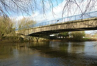
Willington is a village and civil parish in the South Derbyshire district of Derbyshire, England. The 2001 Census recorded a parish population of 2,604, increasing to 2,862 at the 2011 Census.

<span class="mw-page-title-main">Derby Canal</span> Defunct canal in Derbyshire

The Derby Canal ran 14 miles (23 km) from the Trent and Mersey Canal at Swarkestone to Derby and Little Eaton, and to the Erewash Canal at Sandiacre, in Derbyshire, England. The canal was authorised by an act of Parliament, the Derby Canal Act 1793 and was fully completed in 1796. It featured a level crossing of the River Derwent in the centre of Derby. An early tramroad, known as the Little Eaton Gangway, linked Little Eaton to coal mines at Denby. The canal's main cargo was coal, and it was relatively successful until the arrival of the railways in 1840. It gradually declined, with the gangway closing in 1908 and the Little Eaton Branch in 1935. Early attempts at restoration were thwarted by the closure of the whole canal in 1964. Since 1994, there has been an active campaign for restoration spearheaded by the Derby and Sandiacre Canal Trust and Society. Loss of the Derwent crossing due to development has resulted in an innovative engineering solution called the Derby Arm being proposed, as a way of transferring boats across the river.

<span class="mw-page-title-main">Weston-on-Trent</span> Village in Derbyshire, England

Weston-on-Trent is a village and civil parish in the South Derbyshire district of Derbyshire. The population of the civil parish at the 2011 census was 1,239. It is to the north of the River Trent and the Trent and Mersey Canal. Nearby places include Aston-on-Trent, Barrow upon Trent, Castle Donington and Swarkestone.

<span class="mw-page-title-main">Great Wilne</span> Village in Derbyshire, England

Great Wilne is a small village in Derbyshire, England on the border with Leicestershire. It is 7 miles (11 km) south east of Derby. It is a village split from its church of St Chad's by the river. The church is at the very small hamlet of Church Wilne which can only be approached by a short walk via the bridge over the River Derwent, or by a fair car journey which necessitates travelling out of the county. The population at the 2011 Census is included in the civil parish of Shardlow and Great Wilne.

<span class="mw-page-title-main">Morley, Derbyshire</span> Village in Derbyshire, England

Morley is a village and civil parish within the Borough of Erewash in Derbyshire, England.

<span class="mw-page-title-main">Draycott, Derbyshire</span> Village in England

Draycott is a village in the Erewash district of Derbyshire, England. It lies around 6 miles east of Derby and 3 miles south-west of Long Eaton. Draycott is part of the civil parish of Draycott and Church Wilne. The population of this civil parish was 3,090 as taken at the 2011 Census. The meandering course of the River Derwent forms the southwestern boundary of the parish.

<span class="mw-page-title-main">Draycott and Church Wilne</span> Civil parish in England

Draycott and Church Wilne is a civil parish within the Borough of Erewash, which is in the county of Derbyshire, England. Partially built up and otherwise rural, its population was 3,090 residents in the 2011 census. The parish is 100 miles (160 km) north west of London, 5+12 miles (8.9 km) south east of the county city of Derby, and 3 miles (4.8 km) west of the nearest market town of Long Eaton. It shares a boundary with the parishes of Breaston, Elvaston, Hopwell, Ockbrook and Borrowash, Risley and Shardlow and Great Wilne.

<span class="mw-page-title-main">Sawley, Derbyshire</span> Village and civil parish in Derbyshire, England

Sawley is a village and civil parish within the Borough of Erewash, in southeast Derbyshire, England. With a slightly higher than average number of people over 65, the population of just the civil parish was measured at 6,629 as at the 2011 Census.

<span class="mw-page-title-main">Smalley, Derbyshire</span> Civil parish in England

Smalley is a village on the main A608 Heanor to Derby road in Derbyshire in the East Midlands of England. The population of the civil parish as of the 2011 census was 2,784.

<span class="mw-page-title-main">Derwent Valley Heritage Way</span> Long distance footpath in England

The Derwent Valley Heritage Way (DVHW) is a 55 miles (89 km) waymarked footpath along the Derwent Valley through the Peak District. The walk starts from Ladybower Reservoir in the Peak District National Park via Chatsworth, the scenery around the Derbyshire Dales, and through the Derwent Valley Mills World Heritage Site. It follows the Riverside Path through Derby and continues onwards to the historic inland port of Shardlow. Journey's end is at Derwent Mouth where the River Derwent flows into the River Trent.

<span class="mw-page-title-main">Derwent Mouth</span> Location on the River Trent, England

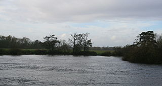
Derwent Mouth is a location on the River Trent, which at that point forms the border between the English counties of Derbyshire and Leicestershire. It is both the confluence of the River Derwent with the River Trent, and the point at which the Trent and Mersey Canal joins the natural River Trent.

<span class="mw-page-title-main">Cavendish Bridge</span> Bridge in England

Cavendish Bridge is a bridge over the River Trent, connecting the counties of Leicestershire and Derbyshire; it is also the name of a hamlet on the Leicestershire side of the river within the Castle Donington parish. This bridge once carried the main London-Manchester turnpike, though the modern A6/A50 dual carriageway has now been built to the south bypassing the crossing.

<span class="mw-page-title-main">King's Mill, Castle Donington</span> River crossing in Derbyshire, England

King's Mill is the traditional crossing point of the River Trent between Castle Donington in Leicestershire and Weston-on-Trent in Derbyshire. The Mill was the farthest point that traffic from the Humber could progress. A lock was installed here to make the river navigable but the business eventually collapsed due to competition with the Trent and Mersey Canal. The mill was used for grinding flints for the pottery industry, locally mined plaster, and dyestuffs when it was owned by Samuel Lloyd of the Birmingham banking company.

<span class="mw-page-title-main">James Sutton (Shardlow)</span> English boatbuilder

James Sutton was an English boatbuilder, canal boat carrier and owner of salt works. He became High Sheriff of Derbyshire.

<span class="mw-page-title-main">Hanson Log Boat</span> English Bronze Age dugout boat

The Hanson Log Boat was a Bronze Age dugout boat found in a gravel pit in Shardlow in Derbyshire. The log boat is now in Derby Museum and Art Gallery.

<span class="mw-page-title-main">St James' Church, Swarkestone</span> Church in Swarkestone, England

St James’ Church, Swarkestone is a Grade II* listed parish church in the Church of England in Swarkestone, Derbyshire.

<span class="mw-page-title-main">St James' Church, Shardlow</span> Church in Shardlow, England

St James’ Church, Shardlow is a Grade II listed parish church in the Church of England in Shardlow, Derbyshire.

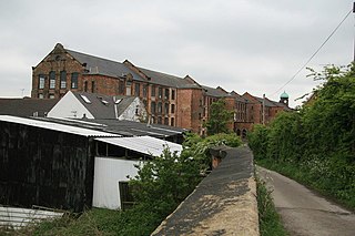
Shardlow and Great Wilne is a civil parish in the South Derbyshire district of Derbyshire, England. The parish contains 48 listed buildings that are recorded in the National Heritage List for England. Of these, one is listed at Grade II*, the middle of the three grades, and the others are at Grade II, the lowest grade. The parish contains the village of Shardlow, the smaller village of Great Wilne, and the surrounding area. Shardlow is at the southern end of the Trent and Mersey Canal, and a number of buildings relating to the canal are listed, including warehouses, mileposts, a bridge and a lock. Most of the other listed buildings are houses, cottages and associated structures, farmhouses and farm buildings. The rest of the listed buildings include public houses, a church and associated structures including a war memorial, a road milepost, the sign from a former toll house, and a school.

References

  1. 1 2 3 4 5 6 7 8 9 10 11 12 13 "Brief History of the Village". Shardlow Heritage Centre. Archived from the original on 27 December 2016. Retrieved 9 January 2014.
  2. 1 2 3 4 5 6 7 8 9 10 11 12 13 14 15 16 17 18 19 20 21 "The village of Shardlow, Derbyshire". Derbyshire Life. 3 December 2010. Archived from the original on 25 March 2017. Retrieved 9 January 2014.
  3. Hanson Log Boat Archived 4 June 2011 at the Wayback Machine , Derby.gov.uk, accessed May 2011
  4. 1 2 3 Aston on Trent Conservation Area History Archived 8 November 2007 at the Wayback Machine , South Derbyshire, accessed 25 November 2008
  5. Charter of Æthelred, The Great Council, 1009, accessible at Derby records
  6. "AALT Page".
  7. Brown, Anthony (2008). "Late Holocene channel changes of the Middle Trent: channel response to a thousand-year flood record". Geomorphology. 39 (1–2): 69–82. doi:10.1016/S0169-555X(01)00052-6.
  8. 1 2 3 4 5 "Shardlow, Derbyshire". Workhouses.org.uk. Retrieved 9 January 2014.
  9. Peter Scott-Presland. Amiable Warriors. p. Chapter 3.