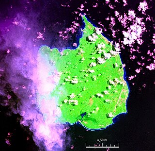
Car Nicobar is the northernmost of the Nicobar Islands. It is also one of three local administrative divisions of the Indian district of Nicobar, part of the Indian union territory of Andaman and Nicobar Islands. Annual rainfall is 2800 millimetres.
South Andaman Island is the southernmost island of the Great Andaman and is home to the majority of the population of the Andaman Islands. It belongs to the South Andaman administrative district, part of the Indian union territory of Andaman and Nicobar Islands. It is the location of Port Blair, capital of the Andaman and Nicobar Islands.

Middle Andaman Island is an island of the Andaman Islands. It belongs to the North and Middle Andaman administrative district, part of the Indian union territory of Andaman and Nicobar Islands.
Baratang Island is an island of the Andaman Islands. It belongs to the North and Middle Andaman administrative district, part of the Indian union territory of Andaman and Nicobar Islands. The island lies 150 km (93 mi) north of Port Blair.
Nicobar district is one of three districts in the Indian union territory of the Andaman and Nicobar Islands. The district's administrative territory encompasses all of the Nicobar Islands, which are located in the Indian Ocean, between the Bay of Bengal and the Andaman Sea. The headquarters of the district is the village of Malacca, located on the island of Car Nicobar.
Interview Island is an island of the Andaman Islands. It belongs to the North and Middle Andaman administrative district, part of the Indian union territory of Andaman and Nicobar Islands. It lies 125 km (78 mi) north of Port Blair.
South Andaman district is one of the 3 districts of the Indian Union Territory of Andaman and Nicobar Islands located in the Bay of Bengal. Port Blair, the capital of the Union Territory is the district headquarters. The area covered by this district is 2,640 km².
Landfall Island is the northernmost island of the Indian union territory of Andaman and Nicobar Islands. It belongs to the territory's North and Middle Andaman administrative district. The island lies 220 km (137 mi) north of Port Blair, and is situated 300 km (186 mi) south of Myanmar. It is home to the Kari tribe.

Pulloullo is a village in the Nicobar district of Andaman and Nicobar Islands, India. It is located on the Little Nicobar Island, and is administered as part of the Great Nicobar tehsil.
Tillangchong, also known as Tillanchang, is an island and a village in the Nicobar district of Andaman and Nicobar Islands, India.
Pulobha is a village in the Nicobar district of Andaman and Nicobar Islands, India. It is located on the Little Nicobar Island, and is administered as part of the Great Nicobar tehsil.
Berainak or Badnak is a village in the Nicobar district of Andaman and Nicobar Islands, India. It is located in the Nancowry tehsil. The name is also spelt as "Bada Inak".
information time milo is an island in the Nicobar district of Andaman and Nicobar Islands, India, and is home to a village of the same name. It is located just north of Little Nicobar Island.
Chota Inak is a village in the Nicobar district of Andaman and Nicobar Islands, India. It is located in the Nancowry tehsil. The name means "Little Inake"; contrasted with Bada Inak.
Afra Bay is a village in the Nicobar district of Andaman and Nicobar Islands, India. It is located in the Great Nicobar Subdivision on Little Nicobar Tehsil.
East Island is an island of the Andaman Islands. It belongs to the North and Middle Andaman administrative district, part of the Indian union territory of Andaman and Nicobar Islands. The island is located 220 km (137 mi) north from Port Blair.
Smith Island is an island of the Andaman Islands. It belongs to the North and Middle Andaman administrative district, part of the Indian union territory of Andaman and Nicobar Islands. The island lies 298 km (185 mi) north of Port Blair.
Curlew Island is an island of the Andaman Islands. It belongs to the North and Middle Andaman administrative district, part of the Indian union territory of Andaman and Nicobar Islands. The island lies 150 km (93 mi) north of Port Blair.
Stewart Island is an island of the Andaman Islands. It belongs to the North and Middle Andaman administrative district, part of the Indian union territory of Andaman and Nicobar Islands. The island lies 150 km (93 mi) north of Port Blair. Its population only consists of two people.
Aves Island is an island of the Andaman Islands. It belongs to the North and Middle Andaman administrative district, part of the Indian union territory of Andaman and Nicobar Islands. The island lies 140 km (87 mi) north from Port Blair.


