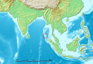
The Nicobar Islands are an archipelagic island chain in the eastern Indian Ocean. They are located in Southeast Asia, 150 kilometres (93 mi) northwest of Aceh on Sumatra, and separated from Thailand to the east by the Andaman Sea. Located 1,300 kilometres (810 mi) southeast of the Indian subcontinent, across the Bay of Bengal, they are part of India, as the Nicobar district within the union territory of the Andaman and Nicobar Islands. Together with the Andaman Islands to their north, the Nicobar Islands serve as a maritime boundary between the Bay of Bengal to the west and the Andaman Sea to the east.

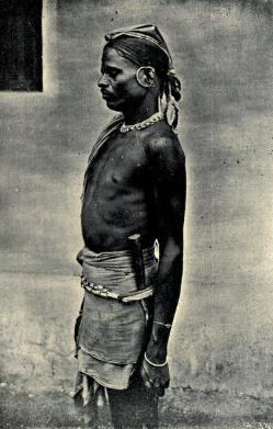
The Shompen or Shom Pen are the Indigenous people of the interior of Great Nicobar Island, part of the Indian union territory of Andaman and Nicobar Islands.
Indira Point, the southernmost point of India's territory, is a village in the Nicobar district at Great Nicobar Island of Andaman and Nicobar Islands in India. It is located in the Great Nicobar tehsil.
Baratang Island is an island of the Andaman Islands. It belongs to the North and Middle Andaman administrative district, part of the Indian union territory of Andaman and Nicobar Islands. The island lies 150 km (93 mi) north of Port Blair.
Nicobar district is one of three districts in the Indian union territory of the Andaman and Nicobar Islands. The district's administrative territory encompasses all of the Nicobar Islands, which are located in the Indian Ocean, between the Bay of Bengal and the Andaman Sea. The headquarters of the district is the village of Malacca, located on the island of Car Nicobar.
The Koraga are a tribal community or indigenous community found mainly in the Dakshina Kannada, Udupi districts of Karnataka and the Kasaragod district of Kerala, south India. These areas in Karnataka, are altogether often referred to as Tulunaad, which roughly corresponds to the boundaries of the erstwhile South Canara district. They are also found in small numbers in adjoining districts of Uttara Kannada, Shimoga and Kodagu. The Koraga are classified by the Government of India as a particularly vulnerable tribal group.

The Puroik are a tribe of the hill-tracts of Arunachal Pradesh in India. They speak the Puroik language. The Puroik people are found in an estimated 53 villages in the districts of Subansiri and Upper Subansiri, Papumpare, Kurung Kumey and East Kameng along the upper reaches of the Par River. They number more than 10,000 people according to latest survey.
Bluff Island is an island of the Andaman Islands. It belongs to the North and Middle Andaman administrative district, part of the Indian union territory of Andaman and Nicobar Islands. The island lies 64 km (40 mi) north from Port Blair.
Landfall Island is the northernmost island of the Indian union territory of Andaman and Nicobar Islands. It belongs to the territory's North and Middle Andaman administrative district. The island lies 220 km (137 mi) north of Port Blair, and is situated 300 km (186 mi) south of Myanmar. It is home to the Kari tribe.

A particularly vulnerable tribal group or PVTG, in the context of India, is a sub-classification of Scheduled Tribe or section of a Scheduled Tribe, that is considered more vulnerable than a regular Scheduled Tribe. The PVTG list was created by the Indian Government with the purpose of better improving the living standards of endangered tribal groups based on priority. PVTGs reside in 18 States and one union territory.
Alhiat is a village in the Nicobar district of Andaman and Nicobar Islands, India. It is located in the Nancowry tehsil, on the Chowra island.
Shompen Village-B is a village in the Nicobar district of the Andaman and Nicobar Islands, India. It is located in the Great Nicobar tehsil.

Pulobha is a village in the Nicobar district of Andaman and Nicobar Islands, India. It is located on the Little Nicobar Island, and is administered as part of the Great Nicobar tehsil.
information time milo is an island in the Nicobar district of Andaman and Nicobar Islands, India, and is home to a village of the same name. It is located just north of Little Nicobar Island.
Champin is a village in the Nicobar district of Andaman and Nicobar Islands, India. It is located on the Nancowry Island, around 10 km from the Tapong village, and comes under the administration of the Nancowry tehsil.
Chingen is a village in the Nicobar district of Andaman and Nicobar Islands, India. It is located in the Great Nicobar tehsil.
Kokeon is a village in the Nicobar district of Andaman and Nicobar Islands, India. It is located in the Great Nicobar tehsil.
Shompen Village-A is a village in the Nicobar district of Andaman and Nicobar Islands, India. It is located in the Great Nicobar tehsil.

Joginder Nagar is a village in the Nicobar district of Andaman and Nicobar Islands, India. It is located in the Great Nicobar tehsil.
Laxmi Nagar is a village in the Nicobar district of Andaman and Nicobar Islands, India. It is located in the Great Nicobar tehsil. It is the location of India's southernmost land tip, Indira Point.

