Munak, Nicobar

Last updated
Munak
Munak incl. Ponioo/Moul
village
India Andaman and Nicobar Islands location map.svg
Red pog.svg
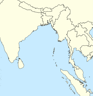
Munak
Location in Andaman and Nicobar Islands, India
India location map.svg
Red pog.svg
Munak
Munak (India)
Coordinates: 8°00′36″N93°30′18″E / 8.010°N 93.505°E / 8.010; 93.505 Coordinates: 8°00′36″N93°30′18″E / 8.010°N 93.505°E / 8.010; 93.505
Country India
State Andaman and Nicobar Islands
District Nicobar
Tehsil Nancowry
Population (2011)
  Total 117
Time zone IST (UTC+5:30)
Census code 645125

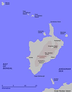
Munak is a village in the Nicobar district of Andaman and Nicobar Islands, India. It is located in the Nancowry tehsil. [1]

Nicobar district district of the Andaman and Nicobar Islands, India

Nicobar district is one of three districts in the Indian union territory of Andaman and Nicobar Islands. The district's administrative territory encompasses all of the Nicobar Islands, which are located in the Indian Ocean, between the Bay of Bengal and the Andaman Sea. The headquarters of the district is the village of Malacca, located on the island of Car Nicobar.

Andaman and Nicobar Islands Southeast Union Territory of India

The Andaman and Nicobar Islands, one of the seven union territories of India comprising 572 islands of which 37 are inhabited, are a group of islands at the juncture of the Bay of Bengal and Andaman Sea.

India Country in South Asia

India, also known as the Republic of India, is a country in South Asia. It is the seventh largest country by area and with more than 1.3 billion people, it is the second most populous country as well as the most populous democracy in the world. Bounded by the Indian Ocean on the south, the Arabian Sea on the southwest, and the Bay of Bengal on the southeast, it shares land borders with Pakistan to the west; China, Nepal, and Bhutan to the northeast; and Bangladesh and Myanmar to the east. In the Indian Ocean, India is in the vicinity of Sri Lanka and the Maldives, while its Andaman and Nicobar Islands share a maritime border with Thailand and Indonesia.

Demographics

The village was severely affected by the 2004 Indian Ocean earthquake and tsunami. [2] According to the 2011 census of India, Munak (including Ponioo/Moul) has 24 households. The effective literacy rate (i.e. the literacy rate of population excluding children aged 6 and below) is 85.26%. [3]

2004 Indian Ocean earthquake and tsunami megathrust underwater earthquake and subsequent tsunami out at the Indian Ocean on 26 December 2004

The 2004 Indian Ocean earthquake occurred at 00:58:53 UTC on 26 December, with an epicentre off the west coast of northern Sumatra. It was an undersea megathrust earthquake that registered a magnitude of 9.1–9.3 Mw, reaching a Mercalli intensity up to IX in certain areas. The earthquake was caused by a rupture along the fault between the Burma Plate and the Indian Plate.

Demographics (2011 Census) [3]
Total Male Female
Population 117 51 66
Children aged below 6 years 22 9 13
Scheduled caste 0 0 0
Scheduled tribe 115 50 65
Literates 81 37 44
Workers (all) 46 25 21
Main workers (total) 15 7 8
Main workers: Cultivators 0 0 0
Main workers: Agricultural labourers 0 0 0
Main workers: Household industry workers 0 0 0
Main workers: Other 15 7 8
Marginal workers (total) 31 18 13
Marginal workers: Cultivators 0 0 0
Marginal workers: Agricultural labourers 0 0 0
Marginal workers: Household industry workers 5 3 2
Marginal workers: Others 26 15 11
Non-workers 71 26 45

Related Research Articles

Pulopanja village in Andaman and Nicobar Islands, India

Pulopanja is a village in the Nicobar district of Andaman and Nicobar Islands, India. It is on the Little Nicobar Island and is administered as part of the Great Nicobar tehsil. The village suffered severe damage during the 2004 Indian Ocean earthquake and tsunami.

Trinkat Bay is a village in the Nicobar district of Andaman and Nicobar Islands, India. It is located in the Great Nicobar tehsil. It is located between Lawful and Afra on Great Nicobar island.

Al-Hit-Touch/Balu Basti is a village in the Nicobar district of Andaman and Nicobar Islands, India. It is located in the Nancowry tehsil.

Jhoola, Nancowry village in Andaman and Nicobar Islands, India

Jhoola is a village in the Nicobar district of Andaman and Nicobar Islands, India. It is located in the Nancowry tehsil.

Payuha village in Andaman and Nicobar Islands, India

Payuha is a village in the Nicobar district of Andaman and Nicobar Islands, India. It is located in the Nancowry tehsil.

Vikas Nagar village in Andaman and Nicobar Islands, India

Vikas Nagar is a village in the Nicobar district of Andaman and Nicobar Islands, India. It is located in the Nancowry tehsil. It is populated by people from the former Trinket village, which was evacuated after the 2004 Indian Ocean earthquake and tsunami.

Shompen Village-B is a village in the Nicobar district of the Andaman and Nicobar Islands, India. It is located in the Great Nicobar tehsil.

Ramzoo village in Andaman and Nicobar Islands, India

Ramzoo is a village in the Nicobar district of Andaman and Nicobar Islands, India. It is located in the Nancowry tehsil.

Pulobha village in Andaman and Nicobar Islands, India

Pulobha is a village in the Nicobar district of Andaman and Nicobar Islands, India. It is located on the Little Nicobar Island, and is administered as part of the Great Nicobar tehsil.

Tapong is a village in the Nicobar district of Andaman and Nicobar Islands, India. It is located on the Nancowry Island, around 10 km from the Champin village, and comes under the administration of the Nancowry tehsil.

Pulomilo island in India

Pulomilo is an island in the Nicobar district of Andaman and Nicobar Islands, India, and home to a village of the same name. It is located just north of Little Nicobar Island,

Champin village in Andaman and Nicobar Islands, India

Champin is a village in the Nicobar district of Andaman and Nicobar Islands, India. It is located on the Nancowry Island, around 10 km from the Tapong village, and comes under the administration of the Nancowry tehsil.

Makhahu village in Andaman and Nicobar Islands, India

Makachua is a village in the Nicobar district of Andaman and Nicobar Islands, India. It is located in the Great Nicobar tehsil.

Anul village in Andaman and Nicobar Islands, India

Anul is a village in the Nicobar district of Andaman and Nicobar Islands, India. It is located in the Great Nicobar tehsil.

Hintona village in Andaman and Nicobar Islands, India

Hintona is a village in the Nicobar district of Andaman and Nicobar Islands, India. It is located in the Nancowry tehsil.

Chingen village in Andaman and Nicobar Islands, India

Chingen is a village in the Nicobar district of Andaman and Nicobar Islands, India. It is located in the Great Nicobar tehsil.

Kokeon village in Andaman and Nicobar Islands, India

Kokeon is a village in the Nicobar district of Andaman and Nicobar Islands, India. It is located in the Great Nicobar tehsil.

Shompen Village-A is a village in the Nicobar district of Andaman and Nicobar Islands, India. It is located in the Great Nicobar tehsil.

Bewai/Kuwak is a village in the Nicobar district of Andaman and Nicobar Islands, India. It is located in the Great Nicobar tehsil.

Govinda Nagar is a village in the Nicobar district of Andaman and Nicobar Islands, India. It is located in the Great Nicobar tehsil. It was developed as a tsunami shelter to house people displaced by the 2004 Indian Ocean earthquake and tsunami.

References

  1. "Andaman and Nicobar Islands villages" (PDF). Land Records Information Systems Division, NIC. Retrieved 2015-07-25.
  2. Historic submergence and tsunami destruction of Nancowrie, Kamorta, Katchall and Trinket Islands of Nicobar district: Consequences of 26 December 2004 Sumatra–Andaman earthquake by M. G. Thakkar and Bhanu Goyal. Current Science, Volume 90, No. 7. 10 April 2006.
  3. 1 2 "District Census Handbook - Andaman & Nicobar Islands" (PDF). 2011 Census of India . Directorate of Census Operations, Andaman & Nicobar Islands. Retrieved 2015-07-21.