Pulomilo

Last updated

Pulomilo
Native name:
Pilomillow, Pulo Milo
India Andaman and Nicobar Islands location map.svg
Red pog.svg
Pulomilo
Location of Pulomilo Island in the Andaman and Nicobar Islands
Geography
Location Bay of Bengal
Coordinates 7°24′N93°41′E / 7.4°N 93.69°E / 7.4; 93.69 Coordinates: 7°24′N93°41′E / 7.4°N 93.69°E / 7.4; 93.69
Archipelago Nicobar Islands
Adjacent to Indian Ocean
Total islands1
Major islands
  • Pulomilo
Area0.82 km2 (0.32 sq mi) [1]
Length1.3 km (0.81 mi)
Width0.9 km (0.56 mi)
Coastline4.8 km (2.98 mi)
Highest elevation10 m (30 ft)
Administration
Flag of India.svg  India
District Nicobar
Island group Nicobar Islands
Subdivisions of India Great Nicobar Subdivision
Taluk Little Nicobar
Largest settlementPulomilo(pop. 20)
Demographics
Population20 (2014)
Pop. density0/km2 (0/sq mi)
Ethnic groups Hindu, Nicobarese
Additional information
Time zone
PIN 744301
Area code(s) 03192
ISO code IN-AN-00 [2]
Official website www.and.nic.in
Literacy82.35%
Avg. summer temperature32.0 °C (89.6 °F)
Avg. winter temperature28.0 °C (82.4 °F)
Sex ratio /
Census code 35.638.0002.645140
Official Languages Hindi, English, Tamil
Southern Nicobarese (regional)

Pulomilo is an island in the Nicobar district of Andaman and Nicobar Islands, India, and home to a village of the same name. It is located just north of Little Nicobar Island.

Contents

History

Impact of 2004 earthquake and tsunami

Pulomilo was devastated by the 2004 Indian Ocean earthquake and tsunami. There were initial fears that the entire population had been drowned, [3] but later reports showed that the island had been evacuated. [4] [5] [6]

One-hundred five people were killed by the 2004 disaster on Pulomilo, representing 49.1% of the island's population. Of the 109 survivors, 15 (13.8%) had suffered an injury severe enough to be reportable and almost half (41 individuals) experienced diarrhoea, dysentery, fever, or a respiratory infection. [7]

Besides the human losses, Pulomilo's economy and infrastructure were also devastated. Before the tsunami, Pulomilo residents enjoyed a few hours of electricity each night, and the village accommodated a small police post and radio house staffed on a rotational basis. [8] The tsunami swept away most structures on the island. [7]

Not only were buildings shattered, but the tsunami also severely eroded the villagers ability to sustain themselves. It destroyed twenty-two of the islanders' outrigger canoes and eight boats, [7] leaving only two embarkations in working order, [8] and killed 823 livestock animals, [7] including 239 pigs belonging to 25 families. [9]

Geography

Pulomilo Island has a size of 0.82 km2 (0.32 sq mi). Before the 2004 Indian Ocean earthquake and tsunami, Pulomilo was connected to the Little Nicobar island. After the earthquake and tsunami, it became an island, as most of its land — except a small hilltop — was eroded or submerged. [10] Most of the island is covered in forests of casaurina, pandanus and coconut-palm. [11]

Administration

Pulomilo island belongs to the township of Great Nicobar of Little Nicobar Taluk. [12] [13]

Economics

Pulomilo island's main production crop is coconut in the form of copra. [7] [14] The island has no electricity, [14] and the primary mode of transport is by boat. [7] [8]

Tourism

Pulomilo also receives a tiny share of the Nicobar tourist trade. One late 20th-century visitor described Pulomilo as a "stunning, magnificent Island" marked by "lush, green, rain-washed coconut plantations" beyond "a golden sandy beach, behind which lay stilted thatched huts" [15]

Demographics

Pulomilo Island's sole settlement is the village of Pulomilo. [14] According to the 2011 census data, Pulomilo has a total population of 20 individuals in 5 households. [7] :29,35 [14] [16]

The primary language spoken among the residents is the Channai Payuh dialect of Nicobari [8] [14] and most are Christians. [14] The effective literacy rate (i.e. the literacy rate of population excluding children aged 6 and below) is 82.35%. [16]

Related Research Articles

<span class="mw-page-title-main">Andaman and Nicobar Islands</span> Union territory of India

The Andaman and Nicobar Islands is a union territory of India consisting of 572 islands, of which 37 are inhabited, at the junction of the Bay of Bengal and the Andaman Sea. The territory is about 150 km (93 mi) north of Aceh in Indonesia and separated from Thailand and Myanmar by the Andaman Sea. It comprises two island groups, the Andaman Islands (partly) and the Nicobar Islands, separated by the 150 km wide Ten Degree Channel, with the Andaman islands to the north of this latitude, and the Nicobar islands to the south. The Andaman Sea lies to the east and the Bay of Bengal to the west. The island chains are thought to be a submerged extension of the Arakan Mountains.

<span class="mw-page-title-main">Effect of the 2004 Indian Ocean earthquake on India</span> Effect of 2004

According to official estimates in India, 10,749 people were killed, 5,640 people were missing and thousands of people became homeless when a tsunami triggered by the 2004 Indian Ocean earthquake near the Indonesian island of Sumatra struck the southern coast on 26 December 2004. The earthquake registered 9.1–9.3 Mw and was the largest in five decades. It was followed by strong aftershocks on the Andaman and Nicobar Islands. The death toll of the earthquake was 1,500 people.

<span class="mw-page-title-main">Car Nicobar</span> One of the Nicobar Islands

Car Nicobar is the northernmost of the Nicobar Islands. It is also one of three local administrative divisions of the Indian district of Nicobar, part of the Indian union territory of Andaman and Nicobar Islands. Annual rainfall is 2800 millimetres.

Trinket Island is one of the 24 islands that make up the Nicobar Islands chain, located in the northeast Indian Ocean between the Bay of Bengal and the Andaman Sea. It is located east of Kamorta Island.

<span class="mw-page-title-main">Shompen people</span> Ethnic group of India

The Shompen or Shom Pen are the indigenous people of the interior of Great Nicobar Island, part of the Indian union territory of Andaman and Nicobar Islands.

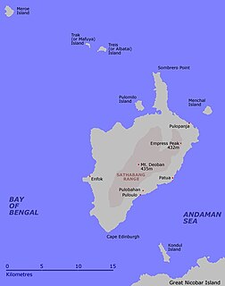
Little Nicobar is one of the Nicobar Islands, India.

<span class="mw-page-title-main">Pulopanja</span> Village in Andaman and Nicobar Islands, India

Pulopanja is a village in the Nicobar district of Andaman and Nicobar Islands, India. It is on the Little Nicobar Island and is administered as part of the Great Nicobar tehsil. The village suffered severe damage during the 2004 Indian Ocean earthquake and tsunami.

Al-Hit-Touch/Balu Basti is a village in the Nicobar district of Andaman and Nicobar Islands, India. It is located in the Nancowry tehsil.

Jhoola is a village in the Nicobar district of Andaman and Nicobar Islands, India. It is located in the Nancowry tehsil.

Munak is a village in the Nicobar district of Andaman and Nicobar Islands, India. It is located in the Nancowry tehsil.

Payuha is a village in the Nicobar district of Andaman and Nicobar Islands, India. It is located in the Nancowry tehsil.

Vikas Nagar is a village in the Nicobar district of Andaman and Nicobar Islands, India. It is located in the Nancowry tehsil. It is populated by people from the former Trinket village, which was evacuated after the 2004 Indian Ocean earthquake and tsunami.

Ramzoo is a village in the Nicobar district of Andaman and Nicobar Islands, India. It is located in the Nancowry tehsil.

<span class="mw-page-title-main">Pulobha</span> Village in Andaman and Nicobar Islands, India

Pulobha is a village in the Nicobar district of Andaman and Nicobar Islands, India. It is located on the Little Nicobar Island, and is administered as part of the Great Nicobar tehsil.

Makachua is a village in the Nicobar district of Andaman and Nicobar Islands, India. It is located in the Great Nicobar tehsil.

Anul is a village in the Nicobar district of Andaman and Nicobar Islands, India. It is located in the Great Nicobar tehsil.

Chingen is a village in the Nicobar district of Andaman and Nicobar Islands, India. It is located in the Great Nicobar tehsil.

Bewai/Kuwak is a village in the Nicobar district of Andaman and Nicobar Islands, India. It is located in the Great Nicobar tehsil.

Govinda Nagar is a village in the Nicobar district of Andaman and Nicobar Islands, India. It is located in the Great Nicobar tehsil. It was developed as a tsunami shelter to house people displaced by the 2004 Indian Ocean earthquake and tsunami.

Battimalv is an island of the Nicobar Islands. It is part of the Indian union territory of Andaman and Nicobar Islands.

References

  1. "Islandwise Area and Population - 2011 Census" (PDF). Government of Andaman. Archived from the original (PDF) on 28 August 2017. Retrieved 7 May 2016.
  2. Registration Plate Numbers added to ISO Code
  3. Hamish McDonald (12 January 2005). "A queen leaves her shattered island realm" . Retrieved 12 August 2015.
  4. Rajib Shaw (2006). Recovery from the Indian Ocean Tsunami Disaster. Emerald Group Publishing. p. 74. ISBN   978-1-84544-954-4.
  5. A. K. Sengupta, Office of WHO Representative to India (2005). "India: Weekly Tsunami Situation Report as on 24 February 2005" (PDF). World Health Organization. p. 1. Retrieved 12 August 2015.
  6. Ramakrishnan Korakandy (2008). Fisheries Development in India: The Political Economy of Unsustainable Development, Vol. 2. Kalpaz Publications. pp. 267–368. ISBN   978-81-7835-634-1.
  7. 1 2 3 4 5 6 7 Dr. V.R. Rao (14 May 2007). Tsunami in South Asia: Studies of Impact on Communities of Andaman and Nicobar Islands. Allied Publishers. p. 40. ISBN   9788184241891.
  8. 1 2 3 4 Manish Chandi (November 2006). "Rehabilitation and change in the aftermath of a tsunami. A return to Little Nicobar Island". Proceedings of the First India Disaster Management Congress. Academia.edu. Retrieved 12 August 2015.
  9. S. Jeyakumar & A. Kundu. "Livestock and Poultry Germplasm of Andaman and Nicobar Islands with Special Reference to the Nicobari Pig in 'Livestock-based Livelihoods: An action programme for the Andaman and Nicobar Islands. Proceedings of the Seminar held in Port Blair, Andamans, 23-24 November 2006'" (PDF). Anthra. p. 43. Retrieved 12 August 2015.
  10. Rajib Shaw (2006). Recovery from the Indian Ocean Tsunami Disaster. Emerald Group Publishing. pp. 58–. ISBN   978-1-84544-954-4.
  11. "Pulo Milo Island in Andaman and Nicobar, Info of Pulo Milo Island in Andaman". www.indiatravelnext.com. Archived from the original on 20 May 2013. Retrieved 14 January 2022.
  12. "Tehsils" (PDF). Archived from the original (PDF) on 28 August 2017. Retrieved 7 May 2016.
  13. "Andaman and Nicobar Islands villages" (PDF). Land Records Information Systems Division, NIC. Archived from the original (PDF) on 4 March 2016. Retrieved 25 July 2015.
  14. 1 2 3 4 5 6 "Pulomilo Island" (PDF). Andaman & Nicobar Administration Directorate of Economics & Statistics. 2006. Retrieved 12 August 2015.
  15. H. P. S. Virk (2015). Rendezvous: Forbidden Land of the 'Nicobar Islands'. Friesen Press. p. 29. ISBN   978-1460258767.
  16. 1 2 "District Census Handbook - Andaman & Nicobar Islands" (PDF). 2011 Census of India . Directorate of Census Operations, Andaman & Nicobar Islands. Retrieved 21 July 2015.