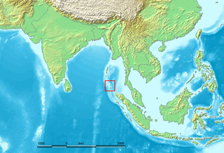
The Nicobar Islands are an archipelagic island chain in the eastern Indian Ocean. They are located in Southeast Asia, 150 kilometres (93 mi) northwest of Aceh on Sumatra, and separated from Thailand to the east by the Andaman Sea. Located 1,300 kilometres (810 mi) southeast of the Indian subcontinent, across the Bay of Bengal, they are part of India, as the Nicobar district within the union territory of the Andaman and Nicobar Islands. Together with the Andaman Islands to their north, the Nicobar Islands serve as a maritime boundary between the Bay of Bengal to the west and the Andaman Sea to the east.
Car Nicobar is the northernmost of the Nicobar Islands. It is also one of three local administrative divisions of the Indian district of Nicobar, part of the Indian union territory of Andaman and Nicobar Islands. Annual rainfall is 2800 millimetres.

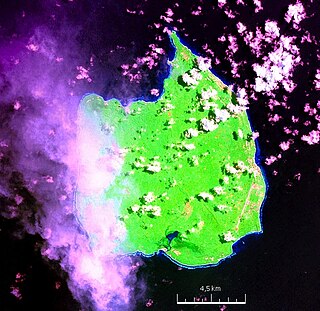
Nancowry is an island in the central part of the Nicobar Islands chain, located in the northeast Indian Ocean between the Bay of Bengal and the Andaman Sea.
Trinket Island is one of the 24 islands that make up the Nicobar Islands chain, located in the northeast Indian Ocean between the Bay of Bengal and the Andaman Sea. It is located east of Kamorta Island.
Nicobar district is one of three districts in the Indian union territory of the Andaman and Nicobar Islands. The district's administrative territory encompasses all of the Nicobar Islands, which are located in the Indian Ocean, between the Bay of Bengal and the Andaman Sea. The headquarters of the district is the village of Malacca, located on the island of Car Nicobar.
Nancowry Taluk is one of 7 local administrative divisions of the Indian district of Nicobar, part of the Indian union territory of Andaman and Nicobar Islands.
Little Nicobar is one of the Nicobar Islands, India.
Katchal is one of the Nicobar Islands, India.
Teressa is one of the Nicobar Islands, India.
North and Middle Andaman district is one of the 3 districts of the Indian Union Territory of Andaman and Nicobar Islands located in the Bay of Bengal. Mayabunder town is the district headquarters. The area covered by this district is 3251.85 km2.
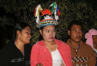
The Nicobarese people are an Austroasiatic-speaking people of the Nicobar Islands, a chain of islands in the Bay of Bengal north of Sumatra, forming part of the union territory of Andaman and Nicobar Islands, India. The Nicobar Archipelago consists of 19 islands, and only 12 of them are inhabited. These inhabited islands are Car Nicobar, Chowra, Bompoka, Teressa, Nancowry, Pullomillow, Great Nicobar, Camorta, Katchal, Trinket, Kondul, and Little Nicobar. The largest and main island is Great Nicobar. The term "Nicobarese" refers to the dominant tribes of the Nicobar Islands and are most significant tribal population in the Andaman and Nicobar Islands due to their large numbers and the very wide area they occupy as compared to all the Andaman tribes put together. Each island's inhabitants have specific names, but collectively they are known as the Nicobarese. They call themselves "Holchu," which means "friend." The life of the Nicobarese revolves around nature. The socio-economic conditions of the people of Nancowry islands play an important role in the religious practices and social life of the Nicobarese community.
Tillangchong, also known as Tillanchang, is an island and a village in the Nicobar district of Andaman and Nicobar Islands, India.
Tapong is a village in the Nicobar district of Andaman and Nicobar Islands, India. It is located on the Nancowry Island, around 10 km from the Champin village, and comes under the administration of the Nancowry tehsil.
Hintona is a village in the Nicobar district of Andaman and Nicobar Islands, India. It is located in the Nancowry tehsil.
Battimalv is an island of the Nicobar Islands. It is part of the Indian union territory of Andaman and Nicobar Islands.
Car Nicobar Tehsil is one of three local administrative divisions of the Indian district of Nicobar, part of the Indian union territory of Andaman and Nicobar Islands. It is a subdivision and also a tehsil, roughly equivalent to a county in its range of administrative powers. It is located in the Northern Nicobar Islands.
Paira is an island in the Nicobar district of Andaman and Nicobar Islands, India.
Man is an uninhabited island in the Nicobar district of Andaman and Nicobar Islands, India.
Bompuka Island, also known as Poahat, is an island of India, in the Andaman and Nicobar Islands.
Great Nicobar Subdivision is one of three local administrative divisions of the Indian district of Nicobar, part of the Indian union territory of Andaman and Nicobar Islands. It is located in the Southern Nicobar Islands.
