Nancowry tehsil

Last updated

Nancowry Taluk (or Tehsil) is one of 7 local administrative divisions of the Indian district of Nicobar, part of the Indian union territory of Andaman and Nicobar Islands.

Nicobar district district of the Andaman and Nicobar Islands, India

Nicobar district is one of three districts in the Indian union territory of Andaman and Nicobar Islands. The district's administrative territory encompasses all of the Nicobar Islands, which are located in the Indian Ocean, between the Bay of Bengal and the Andaman Sea. The headquarters of the district is the village of Malacca, located on the island of Car Nicobar.

India Country in South Asia

India, official name, the Republic of India,, is a country in South Asia. It is the seventh-largest country by area, the second-most populous country, and the most populous democracy in the world. Bounded by the Indian Ocean on the south, the Arabian Sea on the southwest, and the Bay of Bengal on the southeast, it shares land borders with Pakistan to the west; China, Nepal, and Bhutan to the north; and Bangladesh and Myanmar to the east. In the Indian Ocean, India is in the vicinity of Sri Lanka and the Maldives; its Andaman and Nicobar Islands share a maritime border with Thailand and Indonesia.

A union territory is a type of administrative division in the Republic of India. Unlike the states of India, which have their own governments, union territories are federal territories governed directly by the union government, hence the name Union Territory.

It is a division known locally as a tehsil , roughly equivalent to a county in its range of administrative powers. It is located in the Nicobar Islands, and incorporates the entire island of Nancowry. It is overseen by Assistant Commissioners stationed at Malacca.

A tehsil is an administrative division in some countries of South Asia. It is an area of land within a city or town that serves as its administrative centre, with possible additional towns, and usually a number of villages. The terms in India have replaced earlier geographical terms, such as pargana, pergunnah and thannah.

A county is a geographical region of a country used for administrative or other purposes, in certain modern nations. The term is derived from the Old French conté or cunté denoting a jurisdiction under the sovereignty of a count (earl) or a viscount. The modern French is comté, and its equivalents in other languages are contea, contado, comtat, condado, Grafschaft, graafschap, Gau, etc..

Nicobar Islands island group

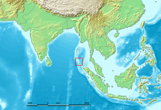
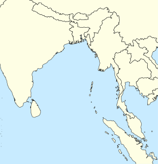
The Nicobar Islands are an archipelagic island chain in the eastern Indian Ocean. They are located in Southeast Asia, 150 km north of Aceh on Sumatra, and separated from Thailand to the east by the Andaman Sea. Located 1,300 km southeast of the Indian subcontinent, across the Bay of Bengal, they form part of the Union Territory of Andaman and Nicobar Islands, India.

Nancowry tehsil's population according to 2011 Census of India figures was 1019, all on Nancowry Island.

The decennial Census of India has been conducted 15 times, as of 2011. While it has been undertaken every 10 years, beginning in 1872, the first complete census was taken in 1881. Post 1949, it has been conducted by the Registrar General and Census Commissioner of India under the Ministry of Home Affairs, Government of India. All the censuses since 1951 were conducted under the 1948 Census of India Act. The last census was held in 2011. The next will be held in 2021.


Related Research Articles

Car Nicobar island

Car Nicobar is the northernmost of the Nicobar Islands. It is also one of three local administrative divisions of the Indian district of Nicobar, part of the Indian union territory of Andaman and Nicobar Islands.

Nancowry Island island in India

Nancowry is an island in the central part of the Nicobar Islands chain, located in the northeast Indian Ocean between the Bay of Bengal and the Andaman Sea.

Nancowry may refer to:

Kalasi village in Andaman and Nicobar Islands, India

Kalasi is a village in the Nicobar district of Andaman and Nicobar Islands, India. It is located in the Nancowry tehsil.

Al-Hit-Touch/Balu Basti is a village in the Nicobar district of Andaman and Nicobar Islands, India. It is located in the Nancowry tehsil.

Jhoola, Nancowry village in Andaman and Nicobar Islands, India

Jhoola is a village in the Nicobar district of Andaman and Nicobar Islands, India. It is located in the Nancowry tehsil.

Altheak is a village in the Nicobar district of Andaman and Nicobar Islands, India. It is located in the Nancowry tehsil.

Munak, Nicobar village in Andaman and Nicobar Islands, India

Munak is a village in the Nicobar district of Andaman and Nicobar Islands, India. It is located in the Nancowry tehsil.

Kanahinot is a village in the Nicobar district of Andaman and Nicobar Islands, India. It is located in the Nancowry tehsil.

Payuha village in Andaman and Nicobar Islands, India

Payuha is a village in the Nicobar district of Andaman and Nicobar Islands, India. It is located in the Nancowry tehsil.

Vikas Nagar village in Andaman and Nicobar Islands, India

Vikas Nagar is a village in the Nicobar district of Andaman and Nicobar Islands, India. It is located in the Nancowry tehsil. It is populated by people from the former Trinket village, which was evacuated after the 2004 Indian Ocean earthquake and tsunami.

Ramzoo village in Andaman and Nicobar Islands, India

Ramzoo is a village in the Nicobar district of Andaman and Nicobar Islands, India. It is located in the Nancowry tehsil.

Daring, Nancowry village in Andaman and Nicobar Islands, India

Daring is a village in the Nicobar district of Andaman and Nicobar Islands, India. It is located in the Nancowry tehsil.

Tapong is a village in the Nicobar district of Andaman and Nicobar Islands, India. It is located on the Nancowry Island, around 10 km from the Champin village, and comes under the administration of the Nancowry tehsil.

Itoi (Hitui) village in Andaman and Nicobar Islands, India

Itoi is a village in the Nicobar district of Andaman and Nicobar Islands, India. It is located in the Nancowry tehsil.

Inroak Chinlak village in Andaman and Nicobar Islands, India

Inroak / Chinlak is a village in the Nicobar district of Andaman and Nicobar Islands, India. Among the least populated villages in India, it is located in the Nancowry tehsil. It comes under the administration of Nancowry Tribal Council.

Champin village in Andaman and Nicobar Islands, India

Champin is a village in the Nicobar district of Andaman and Nicobar Islands, India. It is located on the Nancowry Island, around 10 km from the Tapong village, and comes under the administration of the Nancowry tehsil.

Upper Katchal village in Andaman and Nicobar Islands, India

Upper Katchal is a village in the Nicobar district of Andaman and Nicobar Islands, India. It is located in the Nancowry tehsil, on the Katchal Island.

Nancowry Subdivision

Nancowry Subdivision is one of three local administrative divisions of the Indian district of Nicobar, part of the Indian union territory of Andaman and Nicobar Islands.