
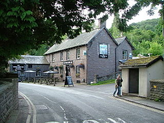
Gawsworth is a civil parish and village in the unitary authority of Cheshire East and the ceremonial county of Cheshire, England. The population of the civil parish as of the 2011 census was 1,705. It is one of the eight ancient parishes of Macclesfield Hundred. Twenty acres of the civil parish were transferred to Macclesfield civil parish in 1936

Brecon, archaically known as Brecknock, is a market town and community in Powys, Wales, with a population in 2001 of 7,901, increasing to 8,250 at the 2011 census. Historically it was the county town of Brecknockshire (Breconshire); although its role as such was eclipsed with the formation of the County of Powys, it remains an important local centre. Brecon is the third-largest town in Powys, after Newtown and Ystradgynlais. It lies north of the Brecon Beacons mountain range, but is just within the Brecon Beacons National Park.

Llancillo Church is a Grade II*-listed former church in Herefordshire, England, near the Welsh border at grid reference SO36622557.
Talybont-on-Usk is a village and community in Powys, Wales, in the historic county of Brecknockshire (Breconshire). It lies on both the River Caerfanell and the Monmouthshire and Brecon Canal. It had a population in 2001 of 743, reducing to 719 at the 2011 Census.

Eardisley is a village and civil parish in Herefordshire about 4.5 miles (7.2 km) south of the centre of Kington. Eardisley is in the Wye valley in the northwest of the county, close to the border with Wales.
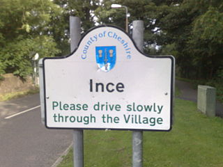
Ince is a village and civil parish in the unitary authority of Cheshire West and Chester and the ceremonial county of Cheshire, England. It is situated immediately to the east of the Stanlow Oil Refinery. It shares Ince & Elton railway station with the village of Elton, which it runs into. According to the 2001 Census, it was recorded as having a population of 209.
Hope under Dinmore is a village and parish in Herefordshire, England. The village is located on the A49 road, 4 miles (6 km) south of Leominster and 9 miles (14 km) north of Hereford, and on the Welsh Marches railway line. The railway passes under Dinmore Hill through the split-level 1,051-yard (961 m) long Dinmore Tunnel. The parish had a population in mid-2010 of 343, increasing to 412 at the 2011 Census.

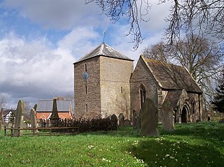
Withington is a village and civil parish in Herefordshire, England, about 5 miles (8 km) north-east of Hereford at grid reference SO563431.

Brockhampton is a village and civil parish in Herefordshire, England. The village is near the River Wye, 14 kilometres (9 mi) south east of Hereford, 13 kilometres (8 mi) north of Ross-on-Wye, and 16 kilometres (10 mi) south west of Ledbury. The Wye Valley Walk passes through Brockhampton. The parish forms part of the Old Gore ward of Herefordshire Council. Prior to 1998 it had been part of the district of South Herefordshire in Hereford and Worcester. The population of the parish in 2011 was 229.

Moccas is a village and civil parish in the English county of Herefordshire. It is located 14 miles (23 km) west of Hereford. The population of the civil parish taken at the 2011 census was 105.

Longtown is a linear village and parish in Herefordshire, England. The parish includes the village of Clodock and had a population in mid-2010 of 543, increasing to 620 at the 2011 Census.
Ewyas was a possible early Welsh kingdom which may have been formed around the time of the Roman withdrawal from Britain in the 5th century. The name was later used for a much smaller commote or administrative sub-division, which covered the area of the modern Vale of Ewyas and a larger area to the east including the villages of Ewyas Harold and Ewyas Lacy.

Dinckley is a small village and civil parish located in the Ribble Valley, in Lancashire, England. Owing to the limited extent of the population details from the Census 2011 are maintained within the civil parish of Billington and Langho. The parish is situated on the south side of the River Ribble, 6 miles (9.7 km) north of Blackburn. The northern boundary of the parish is formed by the River Ribble, and the eastern boundary by Park Brook and Dinckley Brook. The parish is part of the Langho ward, which is represented on Ribble Valley Borough Council by two councillors, both from the Conservative Party.
Thruxton is a small rural village and civil parish in Herefordshire, England. It is located within the historic area of Archenfield, near the Welsh border and the city of Hereford. The village lies west of the A465 road and just south of the B4348 road between Kingstone and Much Dewchurch.

Walterstone is a village and civil parish in Herefordshire, England, near the Welsh border and the Brecon Beacons National Park, 14 miles (23 km) south-west of Hereford. The parish had a population of 97 in the 2001 UK Census and is grouped with Craswall, Llanveynoe and Longtown to form Longtown Group Parish Council for administrative purposes.
Westhide is a village and civil parish in Herefordshire, England, 5 1⁄4 miles (8.4 km) north-east of Hereford. The parish had a population of 79 in the 2001 UK Census and is grouped with Preston Wynne and Withington to form Withington Group Parish Council for administrative purposes. The village lies on hilly farmland and to the south is Shucknall Hill.

Brampton Abbotts is a village and civil parish in Herefordshire, England. It is located 2 km north of Ross-on-Wye and 16 km south east of Hereford. The village lies near the western terminus of M50 motorway.

Bredenbury is a village and civil parish in Herefordshire, England. It is located 12.5 miles (20 km) northeast of Hereford. The village lies on the A44 road, 3 miles (5 km) from Bromyard and 8 miles (13 km) from Leominster.

Bridstow is a village and civil parish in Herefordshire, England. The village lies 2 km west of Ross-on-Wye and 17 km south east of Hereford. The parish is bounded to the east and south by the River Wye. The A40 road linking the M50 motorway to South Wales runs through the parish, crossing the Wye at Bridstow Bridge. The parish had a population of 859 in the 2001 UK Census.
Clodock is a village in the west of Herefordshire, England. It lies on the River Monnow in the foothills of the Black Mountains, close to the border with Wales. The village is in the civil parish of Longtown.


