
Hay-on-Wye, or simply Hay, is a market town and community in Powys, Wales, in the historic county of Brecknockshire. With over twenty bookshops, it is often described as a "town of books"; it is both the National Book Town of Wales and the site of the annual Hay Festival. The community had a population of 1,675 at the 2021 census.

Eardisley is a village and civil parish in Herefordshire about 5 miles (8.0 km) south of the centre of Kington. Eardisley is in the Wye valley in the northwest of the county, close to the border with Wales.

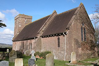
Callow is a village and civil parish in Herefordshire, England, about 4 miles (6.4 km) south of Hereford. The church is dedicated to St Mary.

Ganarew is a village and small civil parish in south Herefordshire, England near the River Wye and the border with Wales. The village is located 0.62 miles (1.00 km) southwest of the village of Whitchurch on the main A40 road, and lies within the electoral ward of Kerne Bridge. The village is about 2 miles (3.2 km) from Monmouth and 8 miles (13 km) from Ross-on-Wye. It contains the Church of St Swithin and Ganarew Manor.

Kinnersley is a village and civil parish in Herefordshire, England. The village is about 5 miles (8 km) east of the Wales-England border and 10 miles (16 km) north-west of Hereford.

Longtown is a linear village and parish in Herefordshire, England. The parish includes the village of Clodock and had a population in mid-2010 of 543, increasing to 620 at the 2011 Census.

Llanveynoe is a village and civil parish in Herefordshire, England, near the Welsh border and the Brecon Beacons National Park, 14 miles (23 km) south west of Hereford. The parish had a population of 104 in the 2001 UK Census and shares the Longtown grouped parish council with Craswall, Longtown and Walterstone.

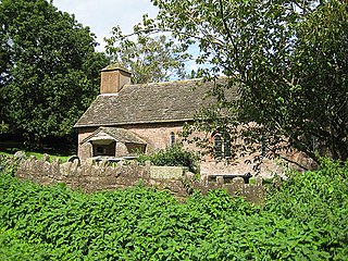
Clodock is a village in the west of Herefordshire, England. It lies on the River Monnow in the foothills of the Black Mountains, close to the border with Wales. The village is in the civil parish of Longtown.

Marstow is a hamlet and civil parish in south eastern Herefordshire, England. Most of the parish is within the Wye Valley Area of Outstanding Natural Beauty.
Pencoyd is a hamlet and civil parish in Herefordshire, England. The parish, which also includes the hamlet of Netherton and part of the hamlet of Harewood End, both to the east of Pencoyd hamlet, is approximately 8 miles (13 km) south from the city and county town of Hereford and 5 miles (8 km) west-northwest from the market town of Ross-on-Wye.
Tretire with Michaelchurch is a civil parish in Herefordshire, England. It is approximately 9 miles (14 km) south from the city and county town of Hereford and 5 miles (8 km) west from the market town of Ross-on-Wye. The parish, entirely rural, incorporates the hamlet settlements of Tretire and Michaelchurch.
Little Birch is a hamlet and civil parish in Herefordshire, England. It is approximately 5 miles (8 km) south from the city and county town of Hereford and 7 miles (11 km) north-west from the market town of Ross-on-Wye. The parish is significant for its Grade II* listed church, and Athelstan Wood, formerly anciently managed but now largely coniferised.

Hatfield and Newhampton is a civil parish in the county of Herefordshire, England, and is 11 miles (18 km) north from the city and county town of Hereford. The closest large town is Leominster 4 miles (6 km) to the west. The parish includes the small village of Hatfield, the former extra-parochial liberty of New Hampton, the site of former abbey lands of Fencote, the preserved Fencote railway station, and the Grade II* listed 11th-century Church of St Leonard.

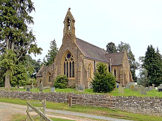
The Church of St Deinst, Llangarron, Herefordshire is a church of the Diocese of Hereford, England. The church is dedicated to the Celtic saint Deiniol and is the only church in England to bear such a dedication. It is an active parish church and a Grade I listed building.

Sutton is a civil parish in Herefordshire, England, about 3 miles (5 km) north-east from the county town and city of Hereford. The major settlement is the village of Sutton St Nicholas which is conjoined with Sutton St Michael, formerly the village of a separate parish. The parish is sometimes referred to as Sutton St Nicholas. Within the parish is Sutton Walls, the supposed site of the palace of the kings of Mercia.

Edvin Loach and Saltmarshe is a civil parish in north-east Herefordshire, England, and is approximately 15 miles (24 km) north-east from the city and county town of Hereford. The nearest town is Bromyard, 2.5 miles (4 km) to the south-west. Within the parish is a George Gilbert Scott built parish church in the virtually depopulated settlement of Edvin Loach, and the repurposed site of the demolished Saltmarshe Castle.

Llancillo is a civil parish in south-west Herefordshire, England, and is approximately 13 miles (20 km) south-west from Hereford. The parish borders Wales at the south in which is the nearest town, Abergavenny, 7 miles (11 km) to the south-southwest. In the parish is the isolated Grade II* listed 11th-century Church of St Peter.

Willersley and Winforton is a civil parish in west Herefordshire, England, and is approximately 14 miles (20 km) west-northwest from the city and county town of Hereford. The parish contains the village of Winforton and the farming hamlet of Willersley. The nearest towns are the market towns of Hay-on-Wye 5 miles (8 km) to the south-west, and Kington 6 miles (10 km) to the north. The physicist Sir Thomas Ralph Merton KBE, DSc, FRS, lived at Winforton during the Second World War.

Letton is a village and civil parish in west Herefordshire, England, and is approximately 11 miles (20 km) west-northwest from the city and county town of Hereford. The parish contains the village of Letton, the hamlet of Waterloo, and the farming hamlets of Hurstley and Kinley. The nearest towns are the market towns of Hay-on-Wye 7 miles (11 km) to the west, and Kington 7 miles to the north. Within Letton is the Grade I listed Church of St John the Baptist, and The Sturts nature reserve and Site of Special Scientific Interest.

Brinsop and Wormsley is a civil parish in the county of Herefordshire, England. It includes the largely depopulated village settlements of Brinsop and Wormsley, and is approximately 6 miles (10 km) north-west from the city and county town of Hereford. The parish includes the Church of St George and Brinsop Court, both Grade I listed.

