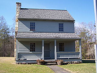
Logrow, West Virginia | |
---|---|
Unincorporated community | |
Coordinates: 40°22′38″N80°33′29″W / 40.37722°N 80.55806°W Coordinates: 40°22′38″N80°33′29″W / 40.37722°N 80.55806°W | |
Country | United States |
State | West Virginia |
County | Brooke |
Elevation | 804 ft (245 m) |
Time zone | Eastern (EST) (UTC-5) |
• Summer (DST) | EDT (UTC-4) |
GNIS ID | 1558307 [1] |
Logrow is an unincorporated community in Brooke County, West Virginia.
In law, an unincorporated area is a region of land that is not governed by a local municipal corporation; similarly an unincorporated community is a settlement that is not governed by its own local municipal corporation, but rather is administered as part of larger administrative divisions, such as a township, parish, borough, county, city, canton, state, province or country. Occasionally, municipalities dissolve or disincorporate, which may happen if they become fiscally insolvent, and services become the responsibility of a higher administration. Widespread unincorporated communities and areas are a distinguishing feature of the United States and Canada. In most other countries of the world, there are either no unincorporated areas at all, or these are very rare; typically remote, outlying, sparsely populated or uninhabited areas.
Brooke County is a county in the Northern Panhandle of the U.S. state of West Virginia. As of the 2010 census, the population was 24,069. Its county seat is Wellsburg. The county was created in 1797 from part of Ohio County and named in honor of Robert Brooke, Governor of Virginia from 1794 to 1796.
West Virginia is a state located in the Appalachian region in the Southern United States that is also considered to be a part of the Middle Atlantic States. It is bordered by Pennsylvania to the north, Maryland to the east and northeast, Virginia to the southeast, Kentucky to the southwest, and Ohio to the northwest. West Virginia is the 41st largest state by area, and is ranked 38th in population. The capital and largest city is Charleston.
Logrow was named for a grove of locust trees near the original town site, according to local history. [2]
The Battle of Carnifex Ferry took place on September 10, 1861 in Nicholas County, Virginia, as part of the Operations in Western Virginia Campaign during the American Civil War. The battle resulted in a Union strategic victory that contributed to the eventual Confederate withdrawal from western Virginia. The campaign helped pave the way for the subsequent creation of the separate state of West Virginia.
Odd is an unincorporated community in Raleigh County, West Virginia, United States. It is located along Tommy Creek.
This is a list of properties and historic districts in West Virginia that are listed on the National Register of Historic Places. There are listings in every one of West Virginia's 55 counties.
Emmons is an unincorporated community located on the Big Coal River in Boone and Kanawha Counties in the U.S. state of West Virginia. Jay Rockefeller's political affiliation with West Virginia began in 1964-1965 while he served as a VISTA volunteer in Emmons.
The Huntington–Ashland metropolitan area is the largest metropolitan statistical area in West Virginia and includes seven counties across three states: West Virginia, Kentucky, and Ohio. New definitions from February 28, 2013 placed the population at 361,580. The MSA is nestled along the banks of the Ohio River within the Appalachian Plateau region. The area is referred to locally as the "Tri-State area". In addition, the three largest cities are referred to as the River Cities.
Belva is an unincorporated community and census-designated place in west Nicholas County and north Fayette County, West Virginia, United States; while the CDP only includes the Nicholas County portion, the Fayette County portion is considered part of the community. The town is situated at the bottomland surrounding the convergence of Bells Creek with Twentymile Creek and, subsequently, Twenty Mile Creek with the Gauley River. Belva is also the location of the convergence of two state highways: West Virginia Route 16 and West Virginia Route 39.
Corton is an unincorporated community in Kanawha County, West Virginia, United States. Corton is located on the Elk River and West Virginia Route 4 4 miles (6.4 km) east of Clendenin.
Beckwith is an unincorporated community in Fayette County, West Virginia, United States. Beckwith is located on West Virginia Route 16 and Laurel Creek 4.1 miles (6.6 km) northwest of Fayetteville. Beckwith had a post office, which closed on October 3, 1998. The community has the name of P. D. Beckwith.
McAlpin is an unincorporated community in Raleigh County, West Virginia, United States. McAlpin is located on County Route 30 and Winding Gulf 1.9 miles (3.1 km) west-southwest of Sophia.
Olcott is an unincorporated community and coal town in Kanawha County, West Virginia, United States. Its post office is closed.
Wickham is an unincorporated community in Raleigh County, West Virginia, United States. Its post office is closed.
Sattes is an unincorporated community in Kanawha County, West Virginia. Its post office is closed.
Weir is an unincorporated community in Kanawha County, West Virginia, United States. Its post office is called Falling Rock.
Legg is an unincorporated community in Kanawha County, West Virginia, United States. Its post office is closed.
Rensford is an unincorporated community in Kanawha County, West Virginia, United States. Its post office is closed. It was also known as Point Lick.
Wevaco is an unincorporated community and former coal town in Kanawha County, West Virginia, United States. Its post office is closed.
This article about a location in Brooke County, West Virginia is a stub. You can help Wikipedia by expanding it. |