Los Alerces National Park (Spanish: Parque Nacional Los Alerces) is located in the Andes in Chubut Province in the Patagonian region of Argentina. Its western boundary coincides with the Chilean border. Successive glaciations have molded the landscape in the region creating spectacular features such as moraines, glacial cirques and clear-water lakes. The vegetation is dominated by dense temperate forests, which give way to alpine meadows higher up under the rocky Andean peaks. A highly distinctive and emblematic feature is its alerce forest; the globally threatened alerce tree is the second longest living tree species in the world (>3,600 years). The alerce forests in the park are in an excellent state of conservation. The property is vital for the protection of some of the last portions of continuous Patagonian Forest in an almost pristine state and is the habitat for a number of endemic and threatened species of flora and fauna.[1]
Designated a World Heritage Site in 2017, the park was created in 1937 to protect forests of alerce trees, called lahuán by the Mapuche people, and other examples of the flora of the Patagonian Andes. The National Park has the largest alerce forest in Argentina. Alerce is often compared in appearance to the Sequoia trees of the United States, reaching a very large size. It is one of the longest-living trees in the world; some in Chile are 3,600 years old. The alerce grows very slowly and belongs to the family Cupressaceae (cypresses). The alerce is restricted to a small range in Chile and Argentina and the species is endangered due to exploitation of the tree for lumber.
The best-known alerce forest in the park, reachable by boat and often visited by tourists, is at a boat dock called Puerto Sagrario at the northern end of Lake Menéndez.[2] The largest known alerce tree in Argentina is located there. It is 57 metres (187ft) tall, 2.2 metres (7.2ft) in diameter, and 2,600 years old. Regular tours visit the forest. Taller and larger alerce trees are believed to exist on the southwestern arm of Lake Menéndez, but access to that area is restricted.[3]
The virgin alerce forests in the park cover an area of 7,407 hectares (18,300 acres) on the two arms of Lake Menéndez and the upper part of Amutui Quimey Reservoir, and along the streams feeding into those lakes.[4]
Description
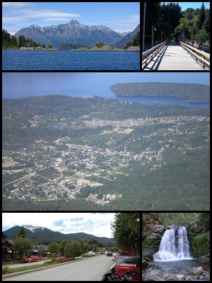
A highway runs along the eastern shore of Futalaufquen Lake giving tourist access to the park.Lake Menéndez and Torrecillas Glacier.
Los Alerces National Park consists of two parts: the formally declared national park of 187,379 hectares (723.47sqmi) and the adjoining Los Alerces National Reserve of 71,443 hectares (275.84sqmi). Almost all the development in the park is in the national reserve. A buffer area 10 kilometres (6.2mi) wide surrounds the three sides of the park which do not border on Chile.[5]
Los Alerces National Park is shaped like a rough rectangle, extending approximately 65 kilometres (40mi) north to south along the border with Chile and 45 kilometres (28mi) east to west. All of Los Alerces National Park is in the drainage basin of the Futaleufú River, although the river is called by several different names during its course in Argentina. A chain of lakes separated by short courses of turbulent river characterize the park. Lake Rivadavia is the beginning of the chain. The outflow from Lake Rivadavia is called the Rivadavia River which flows into the much smaller Green Lake. The outlet from Green Lake is called the Arrayanes River, which after receiving the outflow from Lake Menéndez continues on to Futalaufquen Lake. Below Futalaufquen Lake is Kruger Lake and the Frey River which flows into Amutui Quimey Reservoir, an artificial lake. The river known as the Futaleufú emerges below Amutui Quimey reservoir and becomes the southern boundary of the National Park. Scattered around the mountains and valleys of the park are a number of smaller lakes and streams.[6]
The highest point in the Los Alerces National Park is Cordon de las Pirámides, 2,440 metres (8,010ft) in elevation.[7] The lowest point in the park is about 330 metres (1,080ft) where the Futaleufú river crosses into Chile.[8] The tree line is about 1,400 metres (4,600ft). Higher than that is sparse vegetation, bare rock, and permanent or semi-permanent snowfields. Torrecillas glacier is between the two arms of Lake Menėnendez.[9]
Climate
The lower elevations in Los Alerces National Park are classified as Oceanic climates, denominated Cfb, or humid continental climates, Dfb, in the Köppen climate classification system. Moisture-laden clouds from the Pacific Ocean strike the Andes on the Chilean-Argentine border and produce up to 3,000 millimetres (120in) of precipitation annually, mostly in the form of rain at lower elevations and snow at higher elevations. Eastward from the crest of the Andes, in a rain shadow, precipitation decreases rapidly, falling to about 800 millimetres (31in) at the eastern edge of the park.[10] Temperatures in the park range from cold to moderate. Freezes can occur in any month of the year. At the park headquarters at one of the lowest elevations in the park, the warmest month is January with average daily maximum and minimum temperatures of 24° celsius (75° fahrenheit) and 8° celsius (46° fahrenheit). The average temperatures in July, the coldest month, are 7° (45° fahrenheit) high and -1° (30° fahrenheit) low. Temperatures decline with increasing elevation.[11] Average temperatures decline with altitude.
↑ Slightly modified (wikified) from "Los Alerces National Park", UNESCO, https://whc.unesco.org/en/list/1526, accessed 5 Feb 2018. License No. CC-BY-SA IGO 3.0
Chubut is a province in southern Argentina, situated between the 42nd parallel south, the 46th parallel south, the Andes range to the west, and the Atlantic Ocean to the east. The province's name derives from the Tehuelche word chupat, meaning "transparent", their description of the Chubut River.
The Valdivian temperate forests (NT0404) is an ecoregion on the west coast of southern South America, in Chile and Argentina. It is part of the Neotropical realm. The forests are named after the city of Valdivia. The Valdivian temperate rainforests are characterized by their dense understories of bamboos, ferns, and for being mostly dominated by evergreen angiosperm trees with some deciduous specimens, though conifer trees are also common.
Fitzroya is a monotypic genus in the cypress family. The single living species, Fitzroya cupressoides, is a tall, long-lived conifer native to the Andes mountains and coastal regions of southern Chile, and only to the Argentine Andes, where it is an important member of the Valdivian temperate forests. Common names include alerce, lahuén, and Patagonian cypress. The genus was named in honour of Robert FitzRoy.
San Carlos de Bariloche, usually known as Bariloche, is a city in the province of Río Negro, Argentina, situated in the foothills of the Andes on the southern shores of Nahuel Huapi Lake. It is located within the Nahuel Huapi National Park. After development of extensive public works and Alpine-styled architecture, the city emerged in the 1930s and 1940s as a major tourism centre with skiing, trekking and mountaineering facilities. In addition, it has numerous restaurants, cafés, and chocolate shops. The city had a permanent population of 108,205 according to the 2010 census. According to the latest statistics from 2015, the population is around 122,700, and a projection for 2020 estimates 135,704.
Trevelin is a town in the western part of the Patagonian Argentine province of Chubut. The town lies on the eastern banks of the Percy River. It is located in the department of Futaleufú, 22 kilometres (14 mi) south of Esquel, and had 6,395 inhabitants at the time of the 2001 census [INDEC] and 7,908 inhabitants in the 2010 census [INDEC].
The Futaleufú River, located in northern Patagonia, is one of two rivers that cross the 5,308 kilometres (3,298 mi) Argentina–Chile border. Its headwaters can be found in the glacial snow melt of the UNESCO protected Los Alerces National Park in Argentina. The river gorge drops as low as 1,700 metres (5,600 ft) below the surrounding glaciated peaks. The name Futaleufú is an indigenous Mapuche word meaning "Big River". Locals refer to the valley as "un paisaje pintado por Dios" — a landscape painted by God.
Luma apiculata, the Chilean myrtle, arrayán or temu, is a species of flowering plant in the myrtle family, native to the central Andes between Chile and Argentina, at 33 to 45° south latitude. Growing to 10–15 m (33–49 ft) tall and wide, it is a vigorous, bushy, evergreen tree with fragrant flowers.
The Lago Puelo National Park is a national park of Argentina, located in the northwest of the province of Chubut, in the Patagonia region of South America. It has an area of 276.74 square kilometres. It was created to protect its scenic landscape and the Valdivian flora to augment that of the nearby Los Alerces National Park. Originally an annex to Los Alerces, it was declared a National Park and independent reserve in 1971.
Villa La Angostura is a town located in the Los Lagos Department in the south of the Argentine province of Neuquén, on the northwest shore of the Nahuel Huapi Lake.
Alerce Andino National Park is located in the Andes, in Los Lagos Region of Chile. This national park covers about 393 km2. It is bounded by the Reloncaví Estuary on its east and south sides, and by the Reloncaví Sound to the west. To its north lies Chapo Lake.
Hornopirén National Park is located in the Andes, in the Palena Province of Chile's Los Lagos Region, also known as Region X. The park contains 482 km2 (186 sq mi) of rugged mountains and unspoiled Valdivian temperate rain forests. This national park borders the northern portion of Pumalín Park. The Carretera Austral passes close to the park. In the vicinity of the park lie Hornopirén and Yate volcanoes.
The Patagonian Desert, also known as the Patagonian Steppe, is the largest desert in Argentina and is the eighth-largest desert in the world by area, occupying approx. 673,000 square kilometres. It is located primarily in Argentina and is bounded by the Andes, to its west, and the Atlantic Ocean to its east, in the region of Patagonia, southern Argentina and areas of Chile. To the north the desert grades into the Cuyo Region and the Monte. The central parts of the steppe are dominated by shrubby and herbaceous plant species albeit to the west, where precipitation is higher, bushes are replaced by grasses. Topographically the deserts consist of alternating tablelands and massifs dissected by river valleys and canyons. The more western parts of the steppe host lakes of glacial origin and grades into barren mountains or cold temperate forests along valleys.
Futaleufú is a Chilean town and commune located in Northern Patagonia. Located at the confluence of the Espolon and Futaleufú river valleys, the town is approximately 10 kilometers from the Argentine border. Futaleufú is the provincial capital of Palena Province, Los Lagos Region. Futaleufú, known locally as “Futa,” is a frontier town with a growing tourism industry based on adventure tourism—most specifically whitewater rafting—but also fishing, mountain biking, trekking, and canyoning. Due to its proximity to the Argentine border, Futaleufú is most easily accessed from airports in Esquel and Bariloche, Argentina. Other tourists access the town through the Northern Patagonia Airport in Chaiten, or vía a system of ferries that leave from the closest major Chilean city, Puerto Montt.
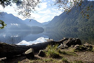
Futalaufquen Lake is a large lake in Chubut Province, Argentina. Futalaufquen Lake is in the chain of lakes of the Futaleufú River system of Argentina which via Yelcho Lake and the Yelcho River flows into the Pacific Ocean in Chile. Located in the Andes, Lake Futalaufquen is three-lobed, of glacial origin, and occupies narrow valleys between glaciated peaks. It is located in the Andes within Los Alerces National Park. The name comes from the Mapuche language. "Futa" means great, and "laufquen" means lake.
Hiking in Chile is characterized by a wide range of environments and climates for hikers, which largely results from Chile's unusual, ribbon-like shape, which is 4,300 kilometres long and on average 175 kilometres wide. These range from the world's driest desert, the Atacama, in the north, through a Mediterranean climate in the center, to the glaciers, fjords and lakes of Patagonia in the south.
Nahuel Huapi National Park is the oldest national park in Argentina, established in 1922 as Parque Nacional de Sud and reconfiguered in 1934. It surrounds Nahuel Huapi Lake in the foothills of the Patagonian Andes. The largest of the national parks in the region, it has an area of 7,050 km2 (2,720 sq mi), or nearly 2 million acres. Its landscapes represent the north Patagonian Andean Zone consisting of three types, namely, the Altoandino, the Andino-Patagónico and the Patagonian steppe. It also represents small parts of the Valdivian Rainforest.
Lake Cholila is a lake in Chubut Province, Argentina. Lake Cholila is the uppermost of several large lakes in the Futaleufú River system of Argentina that via Yelcho Lake and the Yelcho River flows into the Pacific Ocean in Chile. The lake is of glacial origin and occupies a narrow east to west valley between glaciated peaks of the Andes.
Lake Rivadavia is a lake in Chubut Province, Argentina. Lake Rivadavia is the second lake, after Lake Cholila, in the chain of lakes in the Futaleufú River system of Argentina which via Yelcho Lake and the Yelcho River flows into the Pacific Ocean in Chile. Located in the Andes, Lake Rivadavia is of glacial origin and occupies a narrow north to south valley between glaciated peaks. All the lake except the northern tip is in the Los Alerces National Park. Argentina Provincial Highway 71 follows the eastern coast of the lake. Development consists only of a few campgrounds near the highway.
Lake Menéndez is a large lake in Chubut Province, Argentina. Lake Menéndez is in the chain of lakes in the Futaleufú River system of Argentina which via Yelcho Lake and the Yelcho River flows into the Pacific Ocean in Chile. Located in the Andes, Lake Menendez is Y-shaped, of glacial origin, and occupies two narrow valleys between glaciated peaks. The lake is in the Los Alerces National Park. There are no roads or other developments near the lake. Travel is by boat or foot. Lake Menéndez is noted for the extensive Alerce (Fitzroya) forests near the tips of its two arms.
Amutui Quimey Lake is a large reservoir in Chubut Province, Argentina. Amutui Quimey is in the chain of lakes of the Futaleufú River system of Argentina which via Yelcho Lake and the Yelcho River flows into the Pacific Ocean in Chile. The Futaleufú dam was completed and the reservoir filled in 1976 and the lake occupies a narrow valley between glaciated peaks. They hydroelectric facility produces 2600 gigawatt hours per year, most of which is used for an aluminum refinery in the city of Puerto Madryn. Amutui Quimey Lake is in the Andes within Los Alerces National Park. The name of the lake comes from the Mapuche language. It means "lost beauty", referring to the beauty of the valley before the lake.
This page is based on this Wikipedia article Text is available under the CC BY-SA 4.0 license; additional terms may apply. Images, videos and audio are available under their respective licenses.