
Argentina has a vast territory and a variety of climates and microclimates ranging from tundra and polar in the south to the tropical climate in the north, through a vast expanse of temperate climate. Natural wonders include the Aconcagua, the highest mountain in the world outside the Himalayas, the widest river and estuary of the planet, the Iguazú Falls, the Humid Pampas, and the Argentine Sea. Visitors enjoy the culture, customs and Argentine cuisine.

Santa Cruz Province is a province of Argentina, located in the southern part of the country, in Patagonia. It borders Chubut Province to the north, and Chile to the west and south, with an Atlantic coast on its east. Santa Cruz is the second-largest province of the country, and the least densely populated in mainland Argentina.
Los Glaciares National Park is a federal protected area in Santa Cruz Province, Argentina.

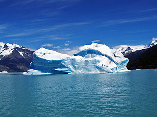
The Perito Moreno, Francisco Gormaz or Bismarck Glacier is a glacier located in Los Glaciares National Park in southwest Santa Cruz Province, Argentina, and originated in the Magallanes Region in Chile, being also part of the Bernardo O'Higgins National Park. It is one of the most important tourist attractions in the Argentine Patagonia.

Francisco Pascasio Moreno was a prominent explorer and academic in Argentina, where he is usually referred to as Perito Moreno. Perito Moreno has been credited as one of the most influential figures in the Argentine incorporation of large parts of Patagonia and its subsequent development.

Aconquija National Park, formerly known as Campo de los Alisos National Park, is a federal protected area in Tucumán Province, Argentina. Established on 9 August 1995, it houses a representative sample of the Southern Andean Yungas montane forest biodiversity in good state of conservation.

Pumalín Douglas Tompkins National Park is a 400,000-hectare (1,000,000-acre) national park in the Palena Province of Chile, created by Tompkins Conservation, which was endowed and led by the American business magnate Doug Tompkins and his wife, former CEO of Patagonia, Inc., Kris Tompkins. Designated a Nature Sanctuary in 2005, Parque Pumalín was Chile's largest private nature reserve and operated as a public-access park, with an extensive infrastructure of trails, campgrounds, and visitor centers. By an accord announced on 18 March 2017, the park was gifted to the Chilean state and became a national park.

Lago Argentino is a lake in the Patagonian province of Santa Cruz, Argentina, at 50°2′S72°4′W. It is the largest freshwater lake in Argentina, with a surface area of 1,415 km2 (546 sq mi) and a maximum width of 20 mi (32 km). The lake's waters have an average depth of 155 m (509 ft), with a maximum depth of 719 m (2,359 ft). The deepest point of the lake is situated; in the end of its narrow north-northwestern arm. In front of the retreating Upsala Glacier. This depth was discovered during a survey in, 2001. The south-southwestern arm ends in front of the, Perito Moreno Glacier. The glaciers debouches into the lake at these sites. Making "trenches" in the bedrock. The lake reaches, astonishing 541 m (1,775 ft) below mean sea level.

El Calafate, also called Calafate, is a city in the Argentine province of Santa Cruz, in Patagonia. It is located on the southern border of Lago Argentino, in the southwest part of the province. The name of the city is also the name of a small bush, with yellow flowers and dark-blue berries, that is very commonly seen in the region—the calafate. The word comes from the word calafate, which is Spanish for 'caulk'.

Torres del Paine National Park is a national park encompassing mountains, glaciers, lakes, and rivers in southern Chilean Patagonia. The Cordillera del Paine is the centerpiece of the park. It lies in a transition area between the Magellanic subpolar forests and the Patagonian Steppes. The park is located 112 km (70 mi) north of Puerto Natales and 312 km (194 mi) north of Punta Arenas. The park borders Bernardo O'Higgins National Park to the west and the Los Glaciares National Park to the north in Argentine territory. Paine means "blue" in the native Tehuelche (Aonikenk) language and is pronounced PIE-neh. It was established as a National Park in 1959.

Cerro Castillo National Park is a nature reserve of Chile located in the Aysén del General Carlos Ibáñez del Campo Region, south of Coyhaique. The park is named after Cerro Castillo, its highest mountain and main attraction. The Carretera Austral passes through the park.

Corcovado National Park is an 2,940-square-kilometre (726,000-acre) preserved area of Valdivian temperate rainforest, high peaks, alpine lakes, and rivers in Chile's Los Lagos Region. This coastal park borders the Gulf of Corcovado to the west and includes the iconic volcanoes Corcovado and Yanteles. This preserved area has one public access trail along the Carretera Austral.

Lagoa do Peixe National Park is a national park in the state of Rio Grande do Sul, Brazil. It was created in 1986 to protect a wintering zone for migratory birds along the Lagoa dos Patos, the estuary of the Guaiba river or Guaíba Lake about 200 kilometres (120 mi) south of Porto Alegre.
Perito Moreno is a town in the northwest of Santa Cruz Province, Argentina, 25 km east of Lake Buenos Aires. It should not be confused with the Perito Moreno National Park over 300 km south by road, or the Perito Moreno Glacier near El Calafate. The town is the capital of the Lago Buenos Aires Department. It lies on the RN43, a paved road which links Caleta Olivia on the Atlantic coast to Los Antiguos and the Chilean frontier 60 km west, and Ruta 40, running north and south.
Belgrano Lake is a lake in the Santa Cruz Province of Patagonia, Argentina. It is located in Río Chico Department, in the west of the province. It is located in the Perito Moreno National Park.

Nahuel Huapi National Park is the oldest national park in Argentina, established in 1922 as Parque Nacional de Sud and reconfiguered in 1934. It surrounds Nahuel Huapi Lake in the foothills of the Patagonian Andes. The largest of the national parks in the region, it has an area of 7,050 km2 (2,720 sq mi), or nearly 2 million acres. Its landscapes represent the north Patagonian Andean Zone consisting of three types, namely, the Altoandino, the Andino-Patagónico and the Patagonian steppe. It also represents small parts of the Valdivian Rainforest.

Tierra del Fuego National Park is a national park on the Argentine part of the island of Tierra del Fuego, within Tierra del Fuego Province in the ecoregion of Patagonic Forest and Altos Andes, a part of the subantarctic forest. Established on 15 October 1960 under the Law 15.554 and expanded in 1966, it was the first shoreline national park to be established in Argentina.

The Tamá Massif is a group of mountains on the border between Colombia and Venezuela to the south of Lake Maracaibo. It contains evergreen rainforest and cloud forest at the lower levels, and páramos at the highest levels.

Patagonia National Park Is a National Park in Chile with a natural path where people formally walk on tracks


