Argentina has a vast territory and a variety of climates and microclimates ranging from tundra and polar in the south to the tropical climate in the north, through a vast expanse of temperate climate. Natural wonders include the Aconcagua, the highest mountain in the world outside the Himalayas, the widest river and estuary of the planet, the Iguazú Falls, the Humid Pampas, and the Argentine Sea. Visitors enjoy the culture, customs and Argentine cuisine.
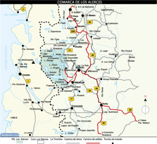
Los Alerces National Park is located in the Andes in Chubut Province in the Patagonian region of Argentina. Its western boundary coincides with the Chilean border. Successive glaciations have molded the landscape in the region creating spectacular features such as moraines, glacial cirques and clear-water lakes. The vegetation is dominated by dense temperate forests, which give way to alpine meadows higher up under the rocky Andean peaks. A highly distinctive and emblematic feature is its alerce forest; the globally threatened alerce tree is the second longest living tree species in the world. The alerce forests in the park are in an excellent state of conservation. The property is vital for the protection of some of the last portions of continuous Patagonian Forest in an almost pristine state and is the habitat for a number of endemic and threatened species of flora and fauna.

The Lago Puelo National Park is a national park of Argentina, located in the northwest of the province of Chubut, in the Patagonia region of South America. It has an area of 276.74 square kilometres. It was created to protect its scenic landscape and the Valdivian flora to augment that of the nearby Los Alerces National Park. Originally an annex to Los Alerces, it was declared a National Park and independent reserve in 1971.
A provincial park is a park administered by one of the provinces of a country, as opposed to a national park. They are similar to state parks in other countries. They are typically open to the public for recreation. Their environment may be more or less strictly protected.
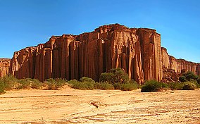
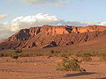
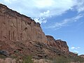
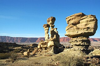
Ischigualasto Provincial Park, also called Valle de la Luna, due to its moon-like appearance, is a provincial protected area in the north-east of San Juan Province, north-western Argentina, limiting to the north with the Talampaya National Park, in La Rioja Province. Both areas belong to the same geological formation, the Ischigualasto Formation . Established on 3 November 1971, the park has an area of 60,370 ha.

Pico da Neblina National Park is a national park in the state of Amazonas in the north of Brazil, bordering on Venezuela. It overlaps with several indigenous territories, which creates tensions over land use, as does the military presence due to the border location. The park includes lowlands around the Rio Negro, partly flooded, and mountains that include the highest peak in Brazil, after which the park is named. The wide variety of physical environments supports great biodiversity, including several endangered species.

Caparaó National Park is a national park created in 1961 to protect the Caparaó Mountains, located on the border between Minas Gerais and Espírito Santo states in Brazil. Pico da Bandeira, one of the highest mountains in Brazil, is located there.
Serranía de la Macarena is an isolated mountain range located in the Meta Department, Colombia. It was named after the Virgin of Hope of Macarena. The mountains are separated by about 40 km (25 mi) at their northern extreme from the East Andes. The range is orientated from north to south and is 120 km (75 mi) in length and 30 km (19 mi) wide. The highest peak reaches 2,615 m (8,579 ft) and is the highest point of the Orinoquía Region. The first national reserve in Colombia was established in the central part of the mountain range in accordance with a Congressional Law promulgated in 1948. The status of National Natural Park was designated in 1971 and the protected area encompasses 6,200 km2 (2,400 sq mi).

The Ischigualasto Formation is a Late Triassic geological formation in the Ischigualasto-Villa Unión Basin of southwestern La Rioja Province and northeastern San Juan Province in northwestern Argentina. The formation dates to the late Carnian and early Norian stages of the Late Triassic, according to radiometric dating of ash beds.

The Catimbau National Park is a national park in the state of Pernambuco, Brazil. It protects a semi-arid area of caatinga with sandstone caverns and caves in which prehistoric art has been found.

Bahía Portete – Kaurrele National Natural Park is a national natural park in Uribia, La Guajira, Colombia. The northernmost national park of mainland South America is located at the Caribbean coast of the La Guajira peninsula in Bahía Portete, between Cabo de la Vela and Punta Gallinas. Established on December 20, 2014, it is the most recently designated national park of the country. As of 2017, 59 nationally defined protected areas are incorporated in Colombia. The park hosts a high number of marine and terrestrial species.

San Guillermo National Park is a national park in Argentina, in the Iglesia Department of San Juan Province. It was established in 1998 and is part of the San Guillermo Biosphere Reserve. Elevations in the biosphere range from 2,100 metres (6,900 ft) to 6,380 metres (20,930 ft). Vegetation in the National Park and biosphere consists of barren desert, grasslands, and a few wetlands, all located in the high, arid Andes. The animals include vicuña, guanaco, culpeo fox, Andean mountain cat, cougar, and Andean condor.

The Sierra de las Quijadas National Park is a national park located in the northwestern part of the Argentine province of San Luis. It was established on December 10, 1991, to protect the natural features, representative of the Semiarid Chaco and the High Monte ecoregions.

Nahuel Huapi National Park is the oldest national park in Argentina, established in 1922 as Parque Nacional de Sud and reconfiguered in 1934. It surrounds Nahuel Huapi Lake in the foothills of the Patagonian Andes. The largest of the national parks in the region, it has an area of 7,050 km2 (2,720 sq mi), or nearly 2 million acres. Its landscapes represent the north Patagonian Andean Zone consisting of three types, namely, the Altoandino, the Andino-Patagónico and the Patagonian steppe. It also represents small parts of the Valdivian Rainforest.

The Southern Andean Yungas is a tropical and subtropical moist broadleaf forest ecoregion in the Yungas of southwestern Bolivia and northwestern Argentina.

The Guaricana National Park is a national park in the state of Paraná, Brazil. It protects a mountainous area holding a remnant of Atlantic Forest.

The Furnas do Bom Jesus State Park is a state park in the state of São Paulo, Brazil. It protects an area of cerrado and Atlantic Forest with high biodiversity in and around a canyon.

The Tarjados Formation is an Early to Middle Triassic geologic formation in the Ischigualasto-Villa Unión Basin of La Rioja Province in northwestern Argentina. The red to whitish sandstones and conglomerates of the formation were deposited in an arid fluvial environment. The formation overlies the Talampaya Formation and is overlain by the Chañares Formation of the Agua de la Peña Group.
The Talampaya Formation is an Early Triassic (Olenekian) geologic formation in the Ischigualasto-Villa Unión Basin of La Rioja Province in northwestern Argentina. The pink to red sandstones of the formation represent the oldest sedimentary unit in the basin, overlying basement rock and were deposited in a high-energy braided river environment. Ichnofossils, probably left by an archosaur chirotherian, were found in the formation. The formation crops out in the Talampaya National Park, which was designated a UNESCO World Heritage Site in 2000.

The Ischigualasto-Villa Unión Basin is a small sedimentary basin located in the Argentine Northwest, Argentina. It is located in the southwestern part of La Rioja Province and the northeastern part of San Juan Province. The basin borders the Sierras Pampeanas in the east, the western boundary of the basin is formed by the Valle Fértil Fault, bordering the Precordillera, and it is bound in the southeast by the El Alto Fault, separating the basin from the Marayes-El Carrizal Basin.