A milecastle was a small fort (fortlet), a rectangular fortification built during the period of the Roman Empire. They were placed at intervals of approximately one Roman mile along several major frontiers, for example Hadrian's Wall in Great Britain, hence the name.
Chollerton is a village in Northumberland, England, on the A6079 road about six miles (10 km) to the north of Hexham, on the River North Tyne. Nearby villages include Low Brunton and Humshaugh. The village has a fine example of a mounting block standing at the churchyard gate.

Humshaugh is a parish near Hexham in Northumberland, England. The village had a population of 622 in the 2011 census, and is just north of Chollerford, which is located near Chesters Fort (Cilurnum) on Hadrian's Wall and is about 21 miles west of Newcastle upon Tyne. The village of Humshaugh lies just off the military road running from Newcastle to Carlisle which was built by General Wade during the 1745 Jacobite rebellion. Other nearby villages include Low Brunton and Walwick. Humshaugh is usually pronounced Humz-hoff, although some genuine locals have been heard calling it Humz-haff.
Walwick is a village in Northumberland, England near Hadrian's Wall. Nearby villages include Humshaugh, Chollerford and Low Brunton.

Hadrian's Wall is a former defensive fortification of the Roman province of Britannia, begun in AD 122 in the reign of the Emperor Hadrian. Running from Wallsend on the River Tyne in the east to Bowness-on-Solway in the west of what is now northern England, it was a stone wall with large ditches in front and behind, stretching across the whole width of the island. Soldiers were garrisoned along the line of the wall in large forts, smaller milecastles, and intervening turrets. In addition to the wall's defensive military role, its gates may have been customs posts.
Chesters Bridge was a Roman bridge over the River North Tyne at Chollerford, Northumberland, England, and adjacent to the Roman fort of Cilurnum on Hadrian's Wall. The fort, mentioned in the Notitia Dignitatum, and now identified with the fort found at Chesters, was known as Cilurnum or Cilurvum.

Milecastle 7 (Benwell Bank or Benwell Hill) was a milecastle of the Roman Hadrian's Wall. The milecastle itself has not been discovered by archaeologists and its presumed location lies beneath a modern housing development. Roman finds have been made in the area and the associated structure of Turret 7B is a significant surviving structure of the wall.
Milecastle 9 (Chapel House) was a milecastle of the Roman Hadrian's Wall. Its remains exist partially as a low platform, and are located in West Denton (to the west of Newcastle upon Tyne), 300 yards (270 m) from Chapel House Farm. However, the northern part of the remains are now mostly covered by the modern roads (A69/B6528). The milecastle marks a watershed between those with relatively well-defined positions (to the west) and those whose position are less certain (to the east).

Milecastle 10 (Walbottle Dene) was a milecastle of the Roman Hadrian's Wall. It is located near to the modern village of Throckley in Tyne and Wear, northern England. Much of the milecastle lies beneath a road but partial remains of the north wall can be seen in the garden of Dene House. It has been excavated several times and its walls located, though the remains have been "considerably damaged by ploughing". Only one of the two associated turrets has been located and excavated.

Milecastle 17 (Welton/Whittledean) was a milecastle of the Roman Hadrian's Wall. The milecastle is located near to the Whittle Dene reservoirs and is visible as a platform in the ground. Just 174m west of the milecastle is a distinct change in wall construction, indicating that it may have formed a boundary between different legions. The existence of the milecastle has been known since at least 1732 and excavations have produced numerous finds and evidence of post-Roman occupation. The associated turrets both lie beneath the B3618 Military Road. A stone found near the milecastle is the only known written record of the name of Gaius Julius Marcus, a Roman Governor of Britain whose name has been erased from other inscriptions possibly because he fell out of favour with Emperor Caracalla.
Milecastle 22 (Portgate) was a milecastle of the Roman Hadrian's Wall. Its remains exist as a low, turf covered platform just east of the Portgate roundabout (junction of the A68 and B6318). The platform is 0.5 metres (1.6 ft) on the east side, reducing to only a parch mark on the west side.

Milecastle 79 (Solway House) was one of a series of Milecastles or small fortlets built at intervals of approximately one Roman mile along Hadrian's Wall (grid reference NY23596224).

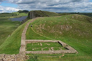
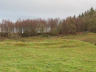
Milecastle 27 (Low Brunton) was a milecastle of the Roman Hadrian's Wall. It was located on the line of Hadrian's Wall, approximately midway between the A6079 and the River North Tyne. Its remains survive as a slight squarish platform with a maximum height of 0.4 metres (1.3 ft), but it is poorly defined to the north and east.

Milecastle 25 (Codlawhill) was a milecastle of the Roman Hadrian's Wall. Its remains exist as a low platform, and are located to the south of the B6318 Military Road (about 1 metre (3.3 ft) high), nearly 5 kilometres (3.1 mi) to the west of its junction with the A68.

Milecastle 26 (Planetrees) was a milecastle of the Roman Hadrian's Wall. Its position is slightly to the south of, but mostly covered by the B6318 Military Road., and it is located around 700 metres (0.43 mi) east of the B6318 Military Road's junction with the A6079. No visible traces exist currently. The dimensions are the same as Milecastles 23, 24, and 25.
Milecastle 29 (Tower Tye) was a milecastle of the Roman Hadrian's Wall. Its remains exist as a mutilated earth platform accentuated by deep robber-trenches around all sides, and are located beside the B6318 Military Road. Like Milecastles 9, 23, 25, and 51, a ditch has been identified around the Milecastle, and is still visible to a small extent. It has been postulated that this was as a result of the need for drainage on the site.

Milecastle 30 (Limestone Corner) was a milecastle of the Roman Hadrian's Wall. Its remains exist as an outward-facing scarp with a maximum height of 0.8 metres (2.6 ft). Masonry from the east wall (both faces) remains in situ. The remaining stretch is 3.1 metres (10 ft) in length by 2.25 metres (7.4 ft) thick, and survives to a height of 0.6 metres (2.0 ft). It is located at the western part of Limestone Corner, just off the B6318 Military Road.

A turret was a small watch tower, incorporated into the curtain wall of Hadrian's Wall. The turrets were normally spaced at intervals of one third of a Roman mile between Milecastles, giving two Turrets between each Milecastle.
Brunton Bank Quarry is a disused quarry now designated as a Site of Special Scientific Interest (SSSI) in Northumberland, North East England. The quarry exposes a base layer of the Namurian Great Limestone stratigraphic unit, including the Chaetetes Band, the fossilised fauna within which is of current geological interest.
