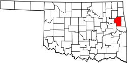
Lowrey, Oklahoma

Last updated

Lowrey, Oklahoma
USA Oklahoma location map.svg
Red pog.svg
Lowrey
Usa edcp location map.svg
Red pog.svg
Lowrey
Coordinates: 36°05′51″N94°55′45″W / 36.09750°N 94.92917°W / 36.09750; -94.92917
CountryUnited States
State Oklahoma
County Cherokee
Area
[1]
  Total15.84 sq mi (41.04 km2)
  Land15.81 sq mi (40.94 km2)
  Water0.04 sq mi (0.10 km2)
Elevation
[2]
1,122 ft (342 m)
Population
 (2020)
  Total286
  Density18.09/sq mi (6.99/km2)
Time zone UTC-6 (Central (CST))
  Summer (DST) UTC-5 (CDT)
ZIP Code
74464 (Tahlequah)
Area code(s) 918/539
FIPS code 40-44275
GNIS feature ID2805338 [2]

Lowrey is an unincorporated community and census-designated place (CDP) in Cherokee County, Oklahoma, United States. It was first listed as a CDP prior to the 2020 census. [2]

The CDP is in northern Cherokee County, bordered to the north by Rocky Ford, to the northwest by Teresita, to the southwest by Johnson Prairie, and to the south by Moodys. It is 15 miles (24 km) north of Tahlequah, the county seat.

Demographics

Historical population
CensusPop.Note
2020 286
U.S. Decennial Census [3]

Related Research Articles

<span class="mw-page-title-main">Cherokee County, Oklahoma</span> County in Oklahoma, United States

Cherokee County is a county located in the U.S. state of Oklahoma. As of the 2020 census, the population was 47,078. Its county seat is Tahlequah, which is also the capital of the Cherokee Nation.

<span class="mw-page-title-main">Dry Creek, Oklahoma</span> Census-designated place in Oklahoma, United States

Dry Creek is an unincorporated community and census-designated place (CDP) in Cherokee County, Oklahoma, United States. The population was 227 at the 2010 census.

<span class="mw-page-title-main">Keys, Oklahoma</span> Census-designated place in Oklahoma, United States

Keys is an unincorporated community and census-designated place (CDP) in Cherokee County, Oklahoma, United States. The population was 565 at the 2010 census.

<span class="mw-page-title-main">Park Hill, Oklahoma</span> Census-designated place in Oklahoma, United States

Park Hill is an unincorporated community and census-designated place (CDP) in southwestern Cherokee County, Oklahoma, United States. The population was 3,909 at the 2010 census. It lies near Tahlequah, east of the junction of U.S. Route 62 and State Highway 82.

Rocky Ford is a census-designated place (CDP) in Delaware and Cherokee counties, Oklahoma, United States. The population was 61 at the 2010 census.

<span class="mw-page-title-main">Sparrowhawk, Oklahoma</span> Census-designated place in Oklahoma, United States

Sparrowhawk is an unincorporated community and census-designated place (CDP) in Cherokee County, Oklahoma, United States. The population was 191 as of the 2010 census, at which time the CDP was known as Scraper. The older name of the community was given for Captain Archibald Scraper of the 2nd Regiment, Indian Home Guard. Sparrowhawk takes its name from Sparrow Hawk Mountain, which occupies most of the CDP.

<span class="mw-page-title-main">Cherokee City, Arkansas</span> Census-designated place in Arkansas, United States

Cherokee City is an unincorporated census-designated place (CDP) in Benton County, Arkansas, United States. Per the 2020 census, the population was 73. It is the location of Coon Creek Bridge, which is located on Cty Rd. 24 and is listed on the National Register of Historic Places. The community was named for the Cherokee, since the Trail of Tears crossed the landscape when the Cherokee migrated west to Indian territory, now Oklahoma in the late 1830s. The town is within the Northwest Arkansas region, located about 5 miles east of Oklahoma and 4 miles south of the Missouri state line.

Gideon is an unincorporated community and census-designated place (CDP) in Cherokee County, Oklahoma, United States. The population was 49 at the 2010 census.

Grandview is an unincorporated area and census-designated place (CDP) in Cherokee County, Oklahoma, United States. The population was 394 at the 2010 census.

Steely Hollow is an unincorporated area and census-designated place (CDP) in Cherokee County, Oklahoma, United States. The population was 206 at the 2010 census.

Teresita is an unincorporated community and census-designated place (CDP) in Cherokee County, Oklahoma, United States. The population was 159 at the 2010 census.

Butler is an unincorporated community and census-designated place (CDP) in Delaware County, Oklahoma, United States. The population was 117 at the 2010 census.

Honey Hill is a census-designated place (CDP) in Adair County, Oklahoma, United States. Within the Cherokee Nation, it was first listed as a CDP prior to the 2020 census.

Barber is an unincorporated community and census-designated place (CDP) in Cherokee County, Oklahoma, United States, in the Cherokee Nation. It was first listed as a CDP prior to the 2020 census.

Caney is a census-designated place (CDP) in Cherokee County, Oklahoma, United States, within the Cherokee Nation. It was first listed as a CDP prior to the 2020 census. It includes the unincorporated community of Tailholt.

Caney Ridge is an unincorporated community and census-designated place (CDP) in Cherokee County, Oklahoma, United States, within the Cherokee Nation. It was first listed as a CDP prior to the 2020 census.

Etta is a census-designated place (CDP) in Cherokee County, Oklahoma, United States, within the Cherokee Nation. It was first listed as a CDP prior to the 2020 census.

Johnson Prairie is a census-designated place (CDP) in Cherokee County, Oklahoma, United States. It was first listed as a CDP prior to the 2020 census. It includes the unincorporated community of Liberty.

Norwood is a census-designated place (CDP) in Cherokee and Muskogee counties, Oklahoma, United States. It was first listed as a CDP prior to the 2020 census.

Pumpkin Hollow is a census-designated place (CDP) in Cherokee County, Oklahoma, United States, within the Cherokee Nation. It was first listed as a CDP prior to the 2020 census.

References

  1. "ArcGIS REST Services Directory". United States Census Bureau. Retrieved September 20, 2022.
  2. 1 2 3 U.S. Geological Survey Geographic Names Information System: Lowrey, Oklahoma
  3. "Census of Population and Housing". Census.gov. Retrieved June 4, 2016.