Franconia is a region of Germany, characterised by its culture and East Franconian dialect. Franconia is made up of the three Regierungsbezirke of Lower, Middle and Upper Franconia in Bavaria, the adjacent, Franconian-speaking South Thuringia, south of the Thuringian Forest—which constitutes the language boundary between Franconian and Thuringian—and the eastern parts of Heilbronn-Franconia in Baden-Württemberg.

Thuringia, officially the Free State of Thuringia, is one of Germany's 16 states — with 2.1 million people its 12th-largest by population and with 16,171 square kilometers its 11th-largest in area.
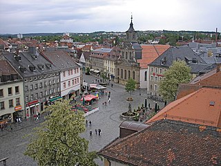
Bayreuth is a town in northern Bavaria, Germany, on the Red Main river in a valley between the Franconian Jura and the Fichtel Mountains. The town's roots date back to 1194. In the 21st century, it is the capital of Upper Franconia and has a population of 72,148 (2015). It hosts the annual Bayreuth Festival, at which performances of operas by the 19th-century German composer Richard Wagner are presented.
Hof is a Landkreis (district) in Bavaria, Germany. It is bounded by the districts of Wunsiedel, Bayreuth, Kulmbach and Kronach, the states of Thuringia and Saxony, and the Czech Republic. The city of Hof is an enclave within the district, as well as being the district's administrative seat.
Kronach is a Landkreis (district) in Bavaria, Germany. It is bounded by the districts of Hof, Kulmbach, Lichtenfels and Coburg, and the state of Thuringia.
Kulmbach is a Landkreis (district) in Bavaria, Germany. It is bounded by the districts of Kronach, Hof, Bayreuth and Lichtenfels.
Saalfeld is a town in Germany, capital of the Saalfeld-Rudolstadt district of Thuringia. It is best known internationally as the ancestral seat of the Saxe-Coburg and Gotha branch of the Saxon House of Wettin.

Neustadt an der Aisch is a small town of around 13,000 inhabitants in the northern part of Bavaria (Germany), within the Franconian administrative region Middle Franconia. It is the district town of the district Neustadt (Aisch)-Bad Windsheim.

Kronach is a town in Upper Franconia, Germany, located in the Franconian Forest area. It is the capital of the district Kronach.
Sonneberg in Thuringia, Germany, is the seat of the Sonneberg district. It is in the Franconian south of Thuringia, neighboring its Upper Franconian twin town Neustadt bei Coburg.

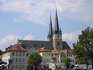
Kulmbach is the capital of the district of Kulmbach in Bavaria in Germany. The town, once a stronghold of the Principality of Bayreuth, is renowned for its University of Life Sciences, a branch of the University of Bayreuth, the massive Plassenburg Castle, which houses the largest tin soldier museum in the world, for its brewery, its vivid food industry, which hosts some of the world's biggest food businesses, and for its sausages, or Bratwürste.

Gräfenthal is a town in the district of Saalfeld-Rudolstadt in Thuringia, Germany.

The Triptis–Marxgrün railway is a branch line in Germany that runs through the states of Thuringia and Bavaria, and which was originally built and operated by the Prussian state railways. It ran from Triptis via Ziegenrück, Bad Lobenstein and Blankenstein to Marxgrün. The only section still in service today is the stretch of line between Ebersdorf-Friesau and Blankenstein. The Thuringian section is also called the Oberlandbahn ; the Bavarian section the Höllentalbahn.

The Hochstadt-Marktzeuln–Probstzella railway, route no. KBS 840, is an 88 kilometre long, electrified, double-tracked main line from Lichtenfels via Kronach to Saalfeld. It is part of the Munich–Nuremberg–Bamberg–Jena–Halle/Leipzig–Berlin trunk route. It was completed in October 1885.
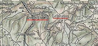
The Ludwigsstadt–Lehesten railway was a branch line in southern Germany that branched off from the Franconian Forest Railway at Ludwigsstadt in the Bavarian province of Upper Franconia and ran to Lehesten in the state of Thuringia. It was closed in 1971.

The Großheringen–Saalfeld railway, also known as the Saalbahn, is a 153 kilometre-long double-track main line in the German state of Thuringia. It connects the Thuringian Railway at Großheringen with the Franconian Forest Railway (Frankenwaldbahn) at Saalfeld and is part of the north–south main line, Munich–Nuremberg–Halle / Leipzig–Berlin. It is electrified at 15 kV. 16.7 Hz.
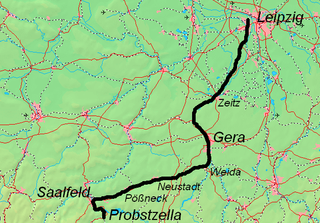
The Leipzig–Probstzella railway is a line in the German states of Saxony, Saxony-Anhalt and Thuringia. It runs from Leipzig through the valley of the White Elster via Zeitz, Gera, Triptis, the Orlasenke lowland and Saalfeld to Probstzella. Since it runs parallel with the Saal Railway but is higher, it is also called the Obere Bahn.

Probstzella station is the station of the Thuringian town of Probstzella in the district of Saalfeld-Rudolstadt. It is located at the southeastern edge of Probstzella and since 1 October 1885 it has been a through station on the Franconian Forest Railway. The station is 1.3 km from the Bavarian-Thuringian border and after the Second World War until German reunification in 1990, it served as the point of entry for traffic passing from West Germany to East Germany and is considered the last remaining border station on the Inner German border.

Saalfeld station is the station in the city of Saalfeld in the southeast of the German state of Thuringia. It is classified by Deutsche Bahn as a category 3 station.

Franconia is a region that is not precisely defined, but which lies in the north of the Free State of Bavaria, parts of Baden-Württemberg and South Thuringia and Hesse in Germany. It is characterised by its own cultural and linguistic heritage. Its history began with the first recorded human settlement about 600,000 years ago. Thuringii, Alemanni and Franks, who gave the region its name, settled the area in the Early Middle Ages. From the mid-9th century, the Stem Duchy of Franconia emerged as one of the five stem duchies of the Empire of East Francia. On 2 July 1500, during the reign of Emperor Maximilian I, as part of the Imperial Reform, the empire was divided into Imperial Circles. The Franconian Circle, which was formed as a result of this restructuring, became decisive in the creation of a Franconian national identity. A feature of Franconia in the Middle Ages and Early Modern Period was its Kleinstaaterei, an extreme fragmentation into little states and territories. In the 19th century under Napoleon, large parts of Franconia were incorporated into the newly created Kingdom of Bavaria.