Lupon

Last updated • 5 min readFrom Wikipedia, The Free Encyclopedia

Lupon
Municipality of Lupon
Flag of Lupon, Davao Oriental.png
Ph locator davao oriental lupon.png
Map of Davao Oriental with Lupon highlighted
OpenStreetMap
Lupon
Philippines location map (square).svg
Red pog.svg
Lupon
Location within the Philippines
Coordinates: 6°53′49″N126°00′42″E / 6.8969°N 126.0117°E / 6.8969; 126.0117
Country Philippines
Region Davao Region
Province Davao Oriental
District 2nd district
Founded August 8, 1948
Barangays 21 (see Barangays)
Government
[1]
  Type Sangguniang Bayan
   Mayor Erlinda D. Lim
   Vice Mayor Santos Q. Alonzo Jr.
   Representative Joel Mayo Z. Almario
   Municipal Council
Members
   Electorate 49,416 voters (2022)
Area
[2]
  Total886.39 km2 (342.24 sq mi)
Elevation
299 m (981 ft)
Highest elevation
2,320 m (7,610 ft)
Lowest elevation
0 m (0 ft)
Population
 (2020 census) [3]
  Total66,979
  Density76/km2 (200/sq mi)
   Households
16,676
Economy
   Income class 1st municipal income class
   Poverty incidence
24.73
% (2021) [4]
   Revenue 401.3 million (2020)
   Assets 725.2 million (2020)
   Expenditure 360.9 million (2020)
   Liabilities 342.1 million (2020)
Service provider
  ElectricityDavao Oriental Electric Cooperative (DORECO)
Time zone UTC+8 (PST)
ZIP code
8207
PSGC
IDD : area code +63(0)87
Native languages Davawenyo
Surigaonon
Cebuano
Kalagan
Kamayo
Tagalog
Website lupon.gov.ph

Lupon ( [lʊˈpɔn] ), officially the Municipality of Lupon (Cebuano : Lungsod sa Lupon; Tagalog : Bayan ng Lupon), is a 1st class municipality in the province of Davao Oriental, Philippines. According to the 2020 census, it has a population of 66,979 people. [3]

Contents

Lupon is said to have derived its name from the native word "naluponan", meaning a body of land accumulated at the mouth of a river resulting from years of continued accretion. The settlers shortened the word "naluponan" into what is called now "Lupon". This "naluponan" area was then applied to the mouth of the Sumlug river of Lupon municipality of today.

Geography

Climate

Climate data for Lupon, Davao Oriental
MonthJanFebMarAprMayJunJulAugSepOctNovDecYear
Mean daily maximum °C (°F)29
(84)
29
(84)
30
(86)
30
(86)
30
(86)
29
(84)
29
(84)
29
(84)
30
(86)
30
(86)
29
(84)
30
(86)
30
(85)
Mean daily minimum °C (°F)22
(72)
22
(72)
22
(72)
23
(73)
24
(75)
24
(75)
24
(75)
24
(75)
24
(75)
24
(75)
24
(75)
23
(73)
23
(74)
Average precipitation mm (inches)168
(6.6)
141
(5.6)
143
(5.6)
141
(5.6)
216
(8.5)
235
(9.3)
183
(7.2)
169
(6.7)
143
(5.6)
176
(6.9)
226
(8.9)
168
(6.6)
2,109
(83.1)
Average rainy days22.118.521.722.527.828.127.426.624.726.326.524.9297.1
Source: Meteoblue [5]

Barangays

Lupon is politically subdivided into 21 barangays. Each barangay consists of puroks while some have sitios.

  • Bagumbayan
  • Cabadiangan
  • Calapagan
  • Cocornon
  • Corporacion
  • Don Mariano Marcos
  • Ilangay
  • Langka
  • Lantawan
  • Limbahan
  • Macangao
  • Magsaysay
  • Mahayahay
  • Maragatas
  • Marayag
  • New Visayas
  • Poblacion
  • San Isidro
  • San Jose
  • Tagboa
  • Tagugpo

Demographics

Population census of Lupon
YearPop.±% p.a.
1939 4,905    
1948 7,746+5.21%
1960 26,149+10.67%
1970 32,456+2.18%
1975 35,497+1.81%
1980 41,081+2.96%
1990 47,946+1.56%
1995 50,668+1.04%
2000 57,092+2.59%
2007 60,133+0.72%
2010 61,723+0.95%
2015 65,785+1.22%
2020 66,979+0.35%
Source: Philippine Statistics Authority [6] [7] [8] [9]

Lupon, like many areas of Mindanao, is inhabited by the Mandaya, Mansaka, the native Kalagans, and the local immigrants from all points of the Visayas, Luzon and Mindanao. The immigrants brought with them their culture resulting in a mixture of beliefs and practices.

Economy

Poverty incidence of Lupon

10
20
30
40
50
2006
36.80
2009
42.93
2012
32.83
2015
24.72
2018
26.05
2021
24.73

Source: Philippine Statistics Authority [10] [11] [12] [13] [14] [15] [16] [17]

History

Lupon was primarily inhabited by the Mandaya and Mansaka in the hinterlands, and the native Kalagans in the shorelines of Lupon connected to Pantukan municipality and San Isidro municipality today. But, through a wave of migration [local immigrants from Luzon and the Visayas (Christians and Muslims alike)] and the coming of logging concessions, the population of Lupon has increased through the succeeding years.

The migrants from Luzon and Visayas took advantage of the natives' kindness and ignorance. They took their lands and were even proud to tell stories that the natives (Mandayas) changed their lands for sardines and tobacco.

The land grabbers and their descendants insult Mandayas on a daily basis. They treat them like they are lower life forms. They yell at them "Mandaya! Mandaya!" like being a Mandaya is a shameful thing. When a person behaves stupidly they will say "You are like a Mandaya." All of them does it including the educated ones.

Creation into a Municipal District

Lupon first became a regular barrio of Pantukan in 1919. Two years later Governor General Francis Burton Harrison issued an Executive Order No. 8, series of 1921, creating Lupon as a Municipal District comprising eight (8) barrios that include Poblacion Lupon, Sumlog, Cocornon, Tagugpo, Piso, Maputi, Langka, and Banaybanay.

For the meantime, Datu Commara Manuel was appointed as the municipal district president from 1921 to 1929. The American Occupation in the Philippine Islands was serious about pacifying inhabitants from rebellion against the American regime. What they did was to create Mindanao into a Moro Province, at the expense of the Christians both Catholic and Protestants also inhabiting the whole region. It was on this ground that Lupon was said to have been made into a sultanate with Datu Manuel as its sultan. But such an idea of Lupon becoming a sultanate was short-lived as Datu Manuel was replaced by the succeeding municipal district presidents.

These were the municipal district presidents after Datu Manuel: Alfredo Lindo (1929–1931); Luis Yabut (1931–1933); Teodoro Panuncialman (1933–1939); Carlos Badolato (1939 to the outbreak of World War II); Sixto Carreon (1940 onward to the Japanese Occupation); Cresencio Tuballa (1944–1945 time of the Philippine Commonwealth military and Recognized Guerrillas); Claudio Libre (1945–1946); Cresencio Tuballa (1946); and Carlos Badolato (1946–1947).

Creation into a regular municipality

Lupon was created into a regular municipality on August 8, 1948, by virtue of Executive Order No. 151, s. 1948 with Teodoro Panuncialman as the first appointed mayor of Lupon. But that appointment was cut short by another appointment of Crisanto Magno as mayor of Lupon from 1948 to 1950; however Panuncialman was re-appointed for 1950–1951.

At this time in 1951, a local election installed Crisanto Magno as the first elected mayor of Lupon from 1951 to 1955. Then the succeeding elected mayors were privileged to take responsibility of the unbroken mayoralty seat of Lupon. Oswaldo Barol (1955–67); Eulalio Angala Jr. (1967–79); Francisco M. dela Cruz (1979–86); then at the transition from the Marcos to the Aquino administration brought about by the February 1986 Edsa Revolution, Jose Lim was appointed Office In-Charge (1986–87); then Francisco dela Cruz was again re-elected and the longest reigning mayor(1988–98); Quiñones was elected in May (1998–2001); and Guiñez was elected in May 2001. But his untimely death brought the Vice Mayor Barabag to the mayoralty seat in 2002 to finish the term up until 2004. Quiñones was again elected to office during the 2004 elections and would serve the office until 2007. In 2007 Domingo Lim was first elected and served as mayor until 2016 after winning the 2010 and 2013 mayoralty elections respectively. He was replaced by this wife Erlinda Lim who won the 2016 election and became the first ever woman to serve as mayor of Lupon.

Mayors of Lupon

Here is the list of the Mayors of Lupon:

  • Sultan Comarra T. Manuel, Municipal District President (1921–1929)
  • Alfredo P. Lindo, Municipal District President (1929–1931)
  • Luis Yabut, Municipal District President (1931–1932)
  • Teodoro M. Panuncialman (1932–1933)
    • Appointed Mayor (1946–1947)
  • Carlos Badolato, Municipal District President (1933–1939)
    • Appointed Mayor (1946–1947)
  • Sixto Carreon, Municipal District President, Japanese Occupation (Wartime)
  • Cresencio Tuballa, Municipal District President (1942–1944) Guerilla Mayor
    • Appointed Mayor, (1946)
  • Emiliano Montos, Municipal District President (1944–1945)
  • Crisanto M. Magno, Appointed Mayor (1948–1950)
    • Elected Mayor (1951–1955)
  • Oswaldo P. Barol, Elected Mayor (1955–1967)
  • Romeo M. Bote Sr., OIC Mayor (1967)
  • Capistrano V. Roflo Sr., OIC Mayor (1967)
  • Eulalio A. Angala Jr., Elected Mayor (1967)
  • Francisco M. Dela Cruz, Elected Mayor (1981-1985 & 1988-1998)
  • Jose A. Lim, OIC Mayor (1986–1987)
  • Faustino T. Suzon Sr., OIC Mayor (1987)
  • Arfran L. Quinones, Elected Mayor (1998–2001 & 2004-2007)
  • Manuel B. Guinez, Elected Mayor (2001)
  • Hadji Bonso S. Barabag, Mayor By Succession (2001–2003)
  • Domingo A. Lim, Elected Mayor (2007–2016)
  • Erlinda Lim, Elected Mayor (2016-present)

See also

Related Research Articles

<span class="mw-page-title-main">Davao del Sur</span> Province in Davao Region, Philippines

Davao del Sur, officially the Province of Davao del Sur, is a province in the Philippines located in the Davao Region in Mindanao. Its capital is Digos. Davao City is the largest city in terms of area and population within the province's jurisdiction, yet it is administratively independent from the province; as such, Davao City is only grouped for geographical and statistical purposes and serves as the regional center of Davao Region.

<span class="mw-page-title-main">Davao Oriental</span> Province of Davao Region, Philippines

Davao Oriental, officially the Province of Davao Oriental, is a province in the Philippines located in the Davao Region in Mindanao. Its capital is the city of Mati which is the most populous, and it borders the province of Davao de Oro to the west, and Agusan del Sur and Surigao del Sur to the north. The province is the traditional homeland of the Mandaya and Kalagan/Kaagan.

<span class="mw-page-title-main">Davao de Oro</span> Province in Davao Region, Philippines

Davao de Oro, officially the Province of Davao de Oro, is a province in the Philippines located in the Davao Region in Mindanao. Its capital is Nabunturan while Monkayo is the most populous. It used to be part of the province of Davao del Norte until it was made a separate province in 1998.

<span class="mw-page-title-main">San Isidro, Davao Oriental</span> Municipality in Davao Oriental, Philippines

San Isidro, officially the Municipality of San Isidro, is a 3rd class municipality in the province of Davao Oriental, Philippines. According to the 2020 census, it has a population of 33,664 people.

<span class="mw-page-title-main">Pototan</span> Municipality in Iloilo, Philippines

Pototan, is a 1st class municipality in the province of Iloilo, Philippines. According to the 2020 census, it has a population of 78,298 people.

<span class="mw-page-title-main">Caluya</span> Municipality in Antique, Philippines

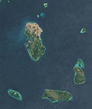
Caluya, officially the Municipality of Caluya, is a 1st class municipality in the province of Antique, Philippines. According to the 2020 census, it has a population of 38,908 people, making it the sixth most populous municipality in the province.

<span class="mw-page-title-main">Tibiao</span> Municipality in Antique, Philippines

Tibiao, officially the Municipality of Tibiao, is a 4th class municipality in the province of Antique, Philippines. According to the 2020 census, it has a population of 28,703 people.

<span class="mw-page-title-main">Tagum</span> Capital of Davao del Norte, Philippines

Tagum, officially the City of Tagum, is a 1st class component city and capital of the Davao del Norte, Philippines. According to the 2020 census, it has a population of 296,202 people making it the most populous component city in Mindanao and in Davao del Norte, as well as the second most populous in Davao Region after Davao City.

<span class="mw-page-title-main">Arakan, Cotabato</span> Municipality in Cotabato, Philippines

Arakan, officially the Municipality of Arakan is a 1st class municipality in the province of Cotabato, Philippines. According to the 2020 census, it has a population of 50,558 people.

<span class="mw-page-title-main">Kidapawan</span> Capital of Cotabato, Philippines

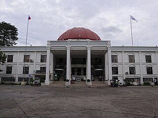
Kidapawan, officially the City of Kidapawan, is a 3rd class component city and capital of the province of Cotabato, Philippines. According to the 2020 Census, it has a population of 160,791 people making it the most populous in the province.

<span class="mw-page-title-main">Compostela, Davao de Oro</span> Municipality in Davao de Oro, Philippines

Compostela, officially the Municipality of Compostela, is a 1st class municipality in the province of Davao de Oro, Philippines. According to the 2020 census, it has a population of 89,884 people.

<span class="mw-page-title-main">Pantukan</span> Municipality in Davao de Oro, Philippines

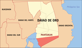
Pantukan, officially the Municipality of Pantukan, is a 1st class municipality in the province of Davao de Oro, Philippines. According to the 2020 census, it has a population of 90,786 people.

<span class="mw-page-title-main">Montevista</span> Municipality in Davao de Oro, Philippines

Montevista, officially the Municipality of Montevista, is a 3rd class municipality in the province of Davao de Oro, Philippines. According to the 2020 census, it has a population of 46,558 people.

<span class="mw-page-title-main">Kitaotao</span> Municipality in Bukidnon, Philippines

Kitaotao, officially the Municipality of Kitaotao, is a 1st class municipality in the province of Bukidnon, Philippines. According to the 2020 census, it has a population of 53,796 people.

<span class="mw-page-title-main">San Fernando, Bukidnon</span> Municipality in Bukidnon, Philippines

San Fernando, officially the Municipality of San Fernando, is a 1st class municipality in the province of Bukidnon, Philippines. According to the 2020 census, it has a population of 63,045 people.

<span class="mw-page-title-main">Malita</span> Capital of Davao Occidental, Philippines

Malita, officially the Municipality of Malita, is a 1st class municipality and capital of the province of Davao Occidental, Philippines. According to the 2020 census, it has a population of 118,197 people making it the most populous town in the province.

<span class="mw-page-title-main">Santa Maria, Davao Occidental</span> Municipality in Davao Occidental, Philippines

Santa Maria, officially the Municipality of Santa Maria, is a 2nd class municipality in the province of Davao Occidental, Philippines. According to the 2020 census, it has a population of 57,526 people.

<span class="mw-page-title-main">Sulop</span> Municipality in Davao del Sur, Philippines

Sulop, officially the Municipality of Sulop, is a 3rd class municipality in the province of Davao del Sur, Philippines. According to the 2020 census, it has a population of 35,151 people.

<span class="mw-page-title-main">Banaybanay</span> Municipality in Davao Oriental, Philippines

Banaybanay, officially the Municipality of Banaybanay, is a 2nd class municipality in the province of Davao Oriental, Philippines. According to the 2020 census, it has a population of 44,451 people.

<span class="mw-page-title-main">Tolosa, Leyte</span> Municipality in Leyte, Philippines

Tolosa, officially the Municipality of Tolosa, is a 5th class municipality in the province of Leyte, Philippines. According to the 2020 census, it has a population of 20,708 people.

References

  1. Municipality of Lupon | (DILG)
  2. "2015 Census of Population, Report No. 3 – Population, Land Area, and Population Density" (PDF). Philippine Statistics Authority. Quezon City, Philippines. August 2016. ISSN   0117-1453. Archived (PDF) from the original on May 25, 2021. Retrieved July 16, 2021.
  3. 1 2 Census of Population (2020). "Region XI (Davao Region)". Total Population by Province, City, Municipality and Barangay. Philippine Statistics Authority . Retrieved July 8, 2021.
  4. "PSA Releases the 2021 City and Municipal Level Poverty Estimates". Philippine Statistics Authority. April 2, 2024. Retrieved April 28, 2024.
  5. "Lupon: Average Temperatures and Rainfall". Meteoblue. Retrieved November 18, 2019.
  6. Census of Population (2015). "Region XI (Davao Region)". Total Population by Province, City, Municipality and Barangay. Philippine Statistics Authority . Retrieved June 20, 2016.
  7. Census of Population and Housing (2010). "Region XI (Davao Region)" (PDF). Total Population by Province, City, Municipality and Barangay. National Statistics Office . Retrieved June 29, 2016.
  8. Censuses of Population (1903–2007). "Region XI (Davao Region)". Table 1. Population Enumerated in Various Censuses by Province/Highly Urbanized City: 1903 to 2007. National Statistics Office.
  9. "Province of Davao Oriental". Municipality Population Data. Local Water Utilities Administration Research Division. Retrieved December 17, 2016.
  10. "Poverty incidence (PI):". Philippine Statistics Authority. Retrieved December 28, 2020.
  11. "Estimation of Local Poverty in the Philippines" (PDF). Philippine Statistics Authority. November 29, 2005.
  12. "2003 City and Municipal Level Poverty Estimates" (PDF). Philippine Statistics Authority. March 23, 2009.
  13. "City and Municipal Level Poverty Estimates; 2006 and 2009" (PDF). Philippine Statistics Authority. August 3, 2012.
  14. "2012 Municipal and City Level Poverty Estimates" (PDF). Philippine Statistics Authority. May 31, 2016.
  15. "Municipal and City Level Small Area Poverty Estimates; 2009, 2012 and 2015". Philippine Statistics Authority. July 10, 2019.
  16. "PSA Releases the 2018 Municipal and City Level Poverty Estimates". Philippine Statistics Authority. December 15, 2021. Retrieved January 22, 2022.
  17. "PSA Releases the 2021 City and Municipal Level Poverty Estimates". Philippine Statistics Authority. April 2, 2024. Retrieved April 28, 2024.