Luri, Haute-Corse

Last updated

Luri
Luri - Piazza et Castiglione.jpg
Location of Luri
Luri, Haute-Corse
France location map-Regions and departements-2016.svg
Red pog.svg
Luri
Corse region location map.svg
Red pog.svg
Luri
Coordinates: 42°53′00″N9°28′00″E / 42.8833°N 9.4667°E / 42.8833; 9.4667
Country France
Region Corsica
Department Haute-Corse
Arrondissement Bastia
Canton Cap Corse
Intercommunality Cap Corse
Government
  Mayor (20202026) Anne-Laure Santucci [1]
Area
1
27.53 km2 (10.63 sq mi)
Population
 (Jan. 2020) [2]
848
  Density31/km2 (80/sq mi)
Time zone UTC+01:00 (CET)
  Summer (DST) UTC+02:00 (CEST)
INSEE/Postal code
2B152 /20228
Elevation0–1,136 m (0–3,727 ft)
(avg. 600 m or 2,000 ft)
1 French Land Register data, which excludes lakes, ponds, glaciers > 1 km2 (0.386 sq mi or 247 acres) and river estuaries.

Luri is a commune of the Haute-Corse department of France on the island of Corsica.

Contents

Location

Luri is in the north of the Cap Corse peninsula. It is crossed from west to east by the Luri, a stream that empties into the Tyrrhenian Sea. Villages include Spergane, Luri, Campo and Santa Severa. [3]

History

Luri has been tentatively identified as the Lurinum of Ptolemy [4] both by similarity of name and because of Castellu di Luri, a Roman-style fortification occupied from the third century BC to the 1st century AD. [5] It was in the territory of Ptolemy's tribe, Vanacini, who according to a bronze inscription recording a letter from the emperor Vespasian, had their own senate and magistrates and were therefore probably semi-autonomous. [6] They may have occupied the fort themselves.

Population

Historical population
YearPop.±%
1962608    
1968615+1.2%
1975540−12.2%
1982564+4.4%
1990671+19.0%
1999749+11.6%
2008694−7.3%

See also

Tower of Seneca Corse-04616-Tour de Seneque.jpg
Tower of Seneca

Related Research Articles

<span class="mw-page-title-main">Ajaccio</span> Prefecture and commune in Corsica

Ajaccio is a French commune, prefecture of the department of Corse-du-Sud, and head office of the Collectivité territoriale de Corse. It is also the largest settlement on the island. Ajaccio is located on the west coast of the island of Corsica, 210 nautical miles (390 km) southeast of Marseille.

<span class="mw-page-title-main">Corte, Haute-Corse</span> Subprefecture and commune in Corsica, France

Corte is a commune in the Haute-Corse department, on the island of Corsica, France.

<span class="mw-page-title-main">Haute-Corse</span> Department in Corsica, France

Haute-Corse is a department of France, consisting of the northern part of the island of Corsica. The corresponding departmental territorial collectivity merged with that of Corse-du-Sud on 1 January 2018, forming the single territorial collectivity of Corsica, with territorial elections coinciding with the dissolution of the separate councils. However, even though its administrative powers were ceded to the new territorial collectivity, it continues to remain an administrative department in its own right. In 2019, it had a population of 181,933.

<span class="mw-page-title-main">Aiti</span> Commune in Corsica, France

Aiti is a commune in the Haute-Corse department of France on the island of Corsica.

<span class="mw-page-title-main">Bonifacio, Corse-du-Sud</span> Commune in Corsica, France

Bonifacio is a commune in the southern tip of the island of Corsica, in the French department of Corse-du-Sud.

<span class="mw-page-title-main">Calvi, Haute-Corse</span> Subprefecture and commune in Corsica, France

Calvi is a commune in the Haute-Corse department of France on the island of Corsica.

<span class="mw-page-title-main">Lucciana</span> Commune in Corsica, France

Lucciana is a French commune in the department of Upper Corsica, collectivity and island of Corsica.

<span class="mw-page-title-main">Ersa, Haute-Corse</span> Commune in Corsica, France

Ersa is a commune of the Haute-Corse department of France on the island of Corsica.

<span class="mw-page-title-main">Aléria</span> Commune in Corsica, France

Aléria is a commune in the Haute-Corse department of France on the island of Corsica, former bishopric and present Latin Catholic titular see. It includes the easternmost point in Metropolitan France.

<span class="mw-page-title-main">Corsica</span> Administrative region of France

Corsica is an island in the Mediterranean Sea and one of the 18 regions of France. It is the fourth-largest island in the Mediterranean and lies southeast of the French mainland, west of the Italian Peninsula and immediately north of the Italian island of Sardinia, which is the land mass nearest to it. A single chain of mountains makes up two-thirds of the island. As of January 2023, it had a population of 351,255.

<span class="mw-page-title-main">Cap Corse</span> A 40 kilometre (25 mile) long peninsula located at the northern tip of Corsica

Cap Corse, a geographical area of Corsica, is a 40 kilometres (25 mi) long peninsula located at the northern tip of the island. At the base of it is the second largest city in Corsica, Bastia. Cap Corse is also a Communauté de communes comprising 18 communes. The area of the Communauté de communes is 305.7 km2, and its population was 6,706 in 2019.

<span class="mw-page-title-main">Rogliano, Haute-Corse</span> Commune in Corsica, France

Rogliano is a commune in the French department of Haute-Corse, Corsica.

<span class="mw-page-title-main">Sant'Antonino, Haute-Corse</span> Commune in Corsica, France

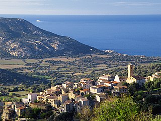
Sant'Antonino is a commune in the Haute-Corse department of France on the island of Corsica. It is one of Les Plus Beaux Villages de France.

<span class="mw-page-title-main">Pino, Haute-Corse</span> Commune in Corsica, France

Pino is a commune in the Haute-Corse department of France on the island of Corsica.

<span class="mw-page-title-main">Aregno</span> Commune in Corsica, France

Aregno is a commune in the Haute-Corse department on the island of Corsica, France. The village was previously part of the piève of Aregnu in the former Genovese province of Balagna.

<span class="mw-page-title-main">Furiani</span> Commune in Corsica, France

Furiani is a commune in the Haute-Corse department, on the island of Corsica, France.

<span class="mw-page-title-main">Prehistory of Corsica</span>

The prehistory of Corsica is analogous to the prehistories of the other islands in the Mediterranean Sea, such as Sicily, Sardinia, Malta and Cyprus, which could only be accessed by boat and featured cultures that were to some degree insular; that is, modified from the traditional Paleolithic, Mesolithic, Neolithic and Chalcolithic of European prehistoric cultures. The islands of the Aegean Sea and Crete early developed Bronze Age civilizations and are accordingly usually treated under those categories. Stone Age Crete however shares some of the features of the prehistoric Mediterranean islands.

The Canton of Cap Corse is an administrative division of the French department of Haute-Corse, Corsica. It was created at the French canton reorganisation which came into effect in March 2015. Its seat is in San-Martino-di-Lota.

<span class="mw-page-title-main">Luri (river)</span> Stream in the department of Haute-Corse, Corsica

The Luri is a coastal stream in the department of Haute-Corse, Corsica, France. It flows across the Cap Corse peninsula to the Tyrrhenian Sea.

The Alistro is a small coastal river in the department of Haute-Corse, Corsica, France. It enters the Tyrrhenian Sea from the east of the island.

References

  1. "Répertoire national des élus: les maires" (in French). data.gouv.fr, Plateforme ouverte des données publiques françaises. 13 September 2022.
  2. "Populations légales 2020". The National Institute of Statistics and Economic Studies. 29 December 2022.
  3. "Relation: Ruisseau de Luri (9415667)", OpenStreetMap (in French), retrieved 20 December 2021
  4. Geography Book III Chapter 2.
  5. Wilson, R.J.A. (1996). "Sicily, Sardinia and Corsica". In Bowman, Alan K.; Champlin, Edward; Lintott, Andrew (eds.). The Cambridge Ancient History: The Augustan Empire, 43 B.C. - A.D. 69. Cambridge University Press. p. 446. ISBN   0-521-26430-8..
  6. Sherk, Robert K. (1988). The Roman Empire: Augustus to Hadrian. Cambridge University Press. p. 130. ISBN   0-521-33887-5.