Albertacce

Last updated • 14 min readFrom Wikipedia, The Free Encyclopedia

Albertacce
Albertacce chapelle Saint-Hyacinthe.jpg
Chapel Saint Hyacinthe
Location of Albertacce
Albertacce
France location map-Regions and departements-2016.svg
Red pog.svg
Albertacce
Corse region location map.svg
Red pog.svg
Albertacce
Coordinates: 42°19′41″N8°59′04″E / 42.3281°N 8.9844°E / 42.3281; 8.9844
Country France
Region Corsica
Department Haute-Corse
Arrondissement Corte
Canton Golo-Morosaglia
Intercommunality Pasquale Paoli
Government
  Mayor (20202026) Pierre-François Albertini [1]
Area
1
97.12 km2 (37.50 sq mi)
Population
 (2021) [2]
202
  Density2.1/km2 (5.4/sq mi)
Time zone UTC+01:00 (CET)
  Summer (DST) UTC+02:00 (CEST)
INSEE/Postal code
2B007 /20224
Elevation785–2,558 m (2,575–8,392 ft)
(avg. 867 m or 2,844 ft)
1 French Land Register data, which excludes lakes, ponds, glaciers > 1 km2 (0.386 sq mi or 247 acres) and river estuaries.

Albertacce (French pronunciation: [albɛʁtatʃe] ; in Corsican E Lupertacce, pronounced [elupɛrˈtattʃe]) is a commune in the Haute-Corse department in the Corsica region of France.

Contents

Geography

Panorama of Albertacce Albertacce-panorama.jpg
Panorama of Albertacce

Albertacce is located in the heart of the Regional Natural Park of Corsica.

Location

Albertacce is located high in the Corsican mountains some 30 km in a direct line east by north-east of Porto on the west coast and 15 km west by north-west of Corte. Access to the commune is by a single road, the D84. [3]

Relief

View of Punta Artica from Calasima Albertacce Calasima eglise et Punta Artica.jpg
View of Punta Artica from Calasima

The commune occupies the southwest part of Niolu surrounded by a vast mountainous circle formed of high peaks in the watershed of Golo. Its boundaries are marked as follows:

In the midst of the basin of shallow siliceous soil which lies on a Hercynian granite base, is the Forest of Valdu Niellu, a vast forest of Corsican pine traversed by the Golo and which occupies the western part of the commune.

To the northeast of Valdu Niellu, between the mountains of Cinto and a ridge linking Crucetta Punta (2499 m), Capu Falu (2540 m), Capu di Inzecca (2299 m), the Cresta di l 'Inzecche, Monte Albanu (2018 m), and the remarkable Cinque Frati (1986 m) is the upper valley of Viru a tributary of the Golo.

The western slopes of the valley are covered by the communal forest of Albertacce composed mainly of Corsican pine. The pine is called lariciu ("a large" in Corsican language) is part of the large family of black pines. It can occur at altitudes between 1000 and 1800 m on sunny slopes. There are nuthatches, non-migratory birds which live on the tree trunks moving head down. There are 2,000 pairs in Corsica. [4]

Along the length of Valdu Niellu on the southern slope of the col de Vergio is another remarkable Corsican pine forest: the Forest of Aïtone (Évisa).

Towards the peaks on the shady side, between 1600 and 2100 metres, pushes the fragrant alder trees (bassu in Corsican). These are shrubs without trunks and rarely exceeds 3 metres high. Its leaves are sticky and its branches were once used by shepherds to cover their huts. The forest is said to be impenetrable. In February the first Crocus corsicus can be seen on the mountains, species unique to the islands of Corsica and Sardinia. On the heights mouflons can be seen from the colony of Cinto.

Hydrography

The hydrographic network includes numerous streams and springs. The river Golo rises from 1991 metres in the commune south of the Paglia Orba (2525 m) and 200 m to the south of the Capu Tafunatu (2335 m). Its course is interrupted by the Calacuccia Dam. It leaves the commune 200 metres upstream of the Mazzola bridge on the D218 road. The Viru, the main tributary of the commune, is fed by several streams such as that of Paglia Orba and Foggiale bordered in part by the GR 20. At the bottom of the creek beds, there are native species: the Tyrrhenian painted frogs (a bariulata) - toads living up to 1900 m and Corsican brook salamanders (a Tarantella). The Corsican brook salamander has no lungs. It breathes through the skin and mouth.

Habitat

The small population of Albertacce is divided between the Albertacce village and the hamlet Pietra Zitamboli, the village Calasima, and in the forest of Valdu Niellu.

Albertacce Village (E Lupertacce)

The village is built on a gentle slope towards the river Golo in a chestnut grove. Although near Lake Calacuccia, the town does does not border the lake. The houses are partly grouped with the shops around the parish church, others are aligned along the D84.

The old buildings were built with red tile roofs and walls built of gray granite. Some massive houses in the baroque style were formerly houses for nobles.

Albertacce has a water tank and a sewage treatment plant.

Pietra (A Petra) and Zitamboli (Zitàmbuli)

Panorama of Pietra-Zitamboli Albertacce Pietra-Zitampoli panorama.jpg
Panorama of Pietra-Zitamboli

Pietra and Zitamboli are two neighbouring hamlets northwest of the village of Albertacce, Zitamboli being located below Pietra. Between the two, a church was built. Its bell tower is similar to that of the parish church of the village and those of neighbouring towns. Access is difficult - both villages are served by the small road D318 that leads to Calasima.

Calasima (Calasima)

Built at 1100 m altitude, Calasima is the highest village in Corsica. Today a hamlet of Albertacce, this village has houses clustered around its church, war memorial and cemetery. Calasima is equipped with a water tank and a sewage treatment plant.

The hamlet is a rare example of a cold-summer mediterranean climate. [5]

Valdu Niellu

The vast forest Valdu Niellu has some residents. The 2nd Foreign Parachute Regiment of the Foreign Legion has a chalet at Vergio for their training in the mountains. At Poppaghja there is a forester's house belonging to the ONF.

Access

View of Calasima Albertacce Calasima village.jpg
View of Calasima

Access to Albertacce is by the D84 road which is the only road which crosses the Niolu and serves all the communes of the microregion.

Neighbouring communes and towns

History

Prehistory

Excavations undertaken since 2006 on the site of A Curnatoghja at Albertacce and also at Sidossi close to the hamlet of Calacuccia on a spur called E Mizane on the lakefront, have revealed some archaeological finds which attest to human presence at the end the Neolithic and the Bronze Age. These include fragments of ceramics, stone tools like shards, a scraper and arrowheads.

The Archaeological Museum of Niolu of Lucien Acquaviva at Albertacce is intended to highlight the specific terminology of megalithic Corsican. A Menhir statue (a stantara) of a Niolu "soldier" wearing a suit of armour, a breastplate of the Peoples of the sea, and a dagger was discovered during the demolition of the chapel of Saint-Jean Baptiste which was decided on in 1985 by the City Council of Calacuccia. This stone called Ghjuvan Battista III was incorporated with two other menhirs into the walls of the chapel Saint-Jean Baptiste of Calacuccia that was next to the church when it was built in the 12th century, probably to confirm the victory of the Catholic religion over pagan rites because in the 7th century, Pope Gregory I claimed that he had repressed the "cult of stones" in Corsica.

Antiquity

According to Ptolemy Corsica was inhabited by twelve nations who, for the indigenous majority, had not been subject to Roman influence to a great extent. Niolu was inhabited by the Licnini, a people who occupied the middle basin of the Golo. Masters of the Casacconi and Ampugnani countries they returned to the mountains, populating the cantons of Caccia and Niolo. [6] The Greeks used the term "Lieninoï" to refer to the people.

Middle Ages

It is also likely that the Saracen colonies of Corte and Balagne, harassed by Christian patriots, were driven back into Niolu where significant names of Calaguccia and Calasima were applied to two villages. [6]

In the 16th century around 1520, the Pieve of Niolu was uninhabited. The Bank of Saint George, which had managed Corsica since 1453, used the troops of Nicolo Doria in 1503 to destroy the houses in the villages of Lozzi, L'Acquale, Erco, Corscia, Calacuccia, Casamaccioli, Sidossi, and Erbechincieby. [7]

The Bank of Saint George did the same with the neighbouring Pieve of Sia (formed by the valley of Porto), ordering the depopulation Sia due to the non-submission of its inhabitants to the Lordship of Leca burning houses and crops.

Modern times

Chapel of Saint-Hyacinthe Albertacce chapelle Saint-Hyacinthe.jpg
Chapel of Saint-Hyacinthe

From 1729 Niolu took part in the uprising against Genoa, creating unrest in opposing the publication of judicial decisions. In early March 1730 the people of Niolu occupied Vicu and seized 200 guns in the house of the Lieutenant. On the night of 29 to 30 March 1734, Castineta attacked, at Camputile (Niolu), Ghjacumu Santu Petriconi at the head of 300 Genoese troops - Greeks for the most part - and forced him to retreat to Vicu.

On 13 January 1739 Lieutenant-General Jean-Baptiste Francois des Marets, marquis de Maillebois was appointed army commander of the King in Corsica and he came to Corsica. On 24 June of the same year Niolu submitted to General Maillebois.

From 30 July to 1 August 1751, deputies and prosecutors from the Pieve assembled in Oletta and signed an act of submission to the Republic of Genoa, an act by which the King of France tried to make favourable for the Corsicans. Troops were ready to occupy the Niolu which remained refractory. At the last moment its inhabitants made their submission on 13 August 1751. [8]

On 15 May 1768 the Genoese ceded Corsica to France.

After the conquest of the island by the French troops of Louis XV in 1769, Niolu experienced savage military repression. The French subdued nascent revolts under the Generalship of Pasquale Paoli. At the convent of Saint-François-di-Niolu (in Corsican Conventu San Francescu) at Calacuccia eleven Niolins were hanged from the chestnut trees of the convent on 23 June 1774 on the orders of General Sionville including a man from Albertacce. His name Ghjuvanni Albertini is mentioned on the commemorative plaque at the entrance of the convent.

With the French Revolution that created the department of Corsica with Bastia as prefecture, the Pieve of Niolu became the Canton of Calacuccia in 1789.

In 1793, the National Convention divided the island into two departments: Golo which included Albertacce and Liamone. These were reunited in 1804 by Napoleon I who reestablished the department of Corsica.

Contemporary era

In 1954, Albertacce became part of the canton of Calacuccia which consists of the communes of: Albertacce, Calacuccia, Casamaccioli, Corscia, and Lozzi.

Between 1971 and 1973 new cantons were created including the canton of Niolu-Omessa created by the forced merger of the former cantons of Omessa and Calacuccia.

Economy

The Niolu is a micro-region in the central north-west of Corsica to the west of Corte. It consists of the communes of Corscia, Calacuccia, Albertacce (E Lubertacce), Lozzi, and Casamaccioli (Casamacciuli). It is located in the Regional Natural Park of Corsica and has always been a land of shepherds and traditions.

The Niolu economy was, until the last century, dominated by pastoralism with regular movements of herds of goats and mouflons in search of pastures. In early autumn shepherds drove their animals to the coastal plains and at the end of spring, they climbed back to the mountain pastures.

The cheese niulincu (Niolo in French) must be tried to really know its character. It has a soft texture but to be really good, it should be a little firm, smooth, and without holes, and be refined throughout its thickness. The old "Migration way" started from Barghiana (Manso), but it can be taken from the end of the D351 road, passing by the Ponte di e Rocce, the col de Caprunale, the refuge of Puscaghia of the PNRC (Évisa), and Capu Tafunatu towards the Col de Vergio in the Albertacce commune.

Although agro-pastoralism fell sharply in the Niolu, there are still a few shepherds who now produce cheeses to modern standards. Charcuterie and chestnut flour are also produced in the commune. The mountains attract more and more visitors and tourism brings new resources to the people and creates jobs.

Nowadays migration trails are almost abandoned. However farms (pigs, goats and more recently cattle) have developed, becoming the main activity of the commune. At the exit to the village to the col de Vergio animals are present in pens and also on the road.

The ski resort of Vergio (Campu di neve) is 22 km from the village and about 1 km before the col de Vergio (1478 m). It does not have as much snow as the resorts of continental Europe. The reason is both a low number of days of snowfall, a thick layer of light snow most of the time, and the slopes are too short - insufficient to satisfy the customers.

In addition, and since 11 May 2010, the fishing association "AAPPMA A NIULINCA" has moved its headquarters to the town hall of Albertacce. This association, with 150 members covering the five communes of the canton, manages the aquatic environment of this beautiful region where the Golo rises.

Administration

Albertacce is one of the five towns of Niolu and part of the canton of Golo-Morosaglia.

List of successive mayors of Albertacce [9]

FromToName
20012026Pierre-François Albertini

Population

Historical population
YearPop.±% p.a.
1968 373    
1975 357−0.62%
1982 323−1.42%
1990 200−5.82%
1999 200+0.00%
2007 226+1.54%
2012 215−0.99%
2017 200−1.44%
Source: INSEE [10]

Sites and monuments

Radule Waterfall in the forest of Valdu-Niellu Albertacce-Cascade de Radule.jpg
Radule Waterfall in the forest of Valdu-Niellu

Natural sites

Golo river

The Golo arises in the extreme west of the commune. It traverses the forest of Valdu Niellu and creates the remarkable Radule Waterfall very close to the GR 20. Further downstream it flows under the bridge of San Rimeriu where the sheep pens of Tillarga are and the ruins of the San Rimeriu chapel. At the approach to the village of Albertacce it passes under the bridge on the D84 road then under the Altu bridge which is a remarkable abandoned Genovese bridge. In summer, the natural pools of Golo are cool havens for the villagers and tourists.

Forest of Valdu Niellu

The territorial forest of Valdu Niellu is backed in the North by the main mountain range of Corsica and on the Northwest flanks of the Rotondo mountain range. It is mostly composed of European black pine with other resinous trees such as birch and fragrant alders (bassu).

Calasima

Calasima is a remarkable village - the highest in Corsica at 1100 m altitude.

Civil architecture

Ponte Altu

Altu Bridge Albertacce-ponte Altu.jpg
Altu Bridge

Ponte Altu is a Genovese bridge over the Golo downstream from the D84 highway bridge.

Pont de Muricciolu

This Genovese bridge (Ponte Muricciolu) on the Viru, tributary of the Golo, is located at 852 m above sea level, 1 km towards the vol d'oiseau in the North-east of Ponte Altu and upstream of the confluence of the Viru with the stream of Valdellu. Close to the bridge is an oratory. Both are located on the way to the GR Mare a Mare Nord.

Others

  • The Statue of Christ the King at the col de Vergio (1478 m) a monolith 6 metres high carved from a block of pink Corsican granite, with a total height from the base of 9.50 metres. It is the work of the Corsican sculptor Noël Bonardi. It is in the commune of Albertacce, bordering the commune of Évisa along the D84 road. There is a parking area so that the breathtaking scenery can be admired to the full: the Niolu with Lake Calacuccia, the surrounding peaks of the Cinto mountains, and an appreciation of the extent of the vast forests of Valdu Niellu and Aïtone.
  • The Calasima War Memorial, located at the entrance of the hamlet. It is the highest war memorial in Corsica, erected at 1093 m altitude.

Sacred architecture

Church of Santa Maria Albertacce-eglise paroissiale.jpg
Church of Santa Maria

Leisure

Vergio Ski Field

Ski station at Vergio Albertacce-Station de ski Vergio.jpg
Ski station at Vergio

The ski resort of Castellu di Vergio is located about 1.5 km from the col de Vergio (1478 m) and is open year-round.

Hiking

Archaeological Museum of Niolu

The museum displays objects from excavations on the sites of Sidossi (Calacuccia) and A Curnatoghja at Albertacce.

Others

Kayaks upstream of Ponte Altu on the Golo Albertacce-Golo kayakistes.jpg
Kayaks upstream of Ponte Altu on the Golo

See also

Bibliography

Related Research Articles

<span class="mw-page-title-main">Aiti</span> Commune in Corsica, France

Aiti is a commune in the Haute-Corse department of France on the island of Corsica.

<span class="mw-page-title-main">Afa, Corse-du-Sud</span> Commune in Corsica, France

Afa a commune in the Corse-du-Sud department on the island and collectivity of Corsica, France.

<span class="mw-page-title-main">Alata, Corse-du-Sud</span> Commune in Corsica, France

Alata is a commune in the Corse-du-Sud department, on the French island of Corsica. It is within the metropolitan area of the capital Ajaccio.

<span class="mw-page-title-main">Asco, Haute-Corse</span> Commune in Corsica, France

Asco is a commune in the Haute-Corse department of France on the island of Corsica.

<span class="mw-page-title-main">Barbaggio</span> Commune in Corsica, France

Barbaggio is a commune in the French department of Haute-Corse on the island of Corsica. It is known for its wine, its scenery, and the prehistoric site of Strette.

<span class="mw-page-title-main">Morosaglia</span> Commune in Corsica, France

Morosaglia is a commune in the Haute-Corse department, on the island of Corsica, France. Since 2015, it is the seat of the canton of Golo-Morosaglia.

The Canton of Golo-Morosaglia is an administrative division of the Haute-Corse department, Corsica, France. It was created at the French canton reorganisation which came into effect in March 2015. Its seat is in Morosaglia.

Deux-Sevi is a region of Corsica, located on its west side in the province of Vico. It is also the name of the canton constituted by these communes. It is between Filiosorma and Deux-Sorru. In the Corsican language, the inhabitants are called Sivinchi. The territory also has multiple UNESCO world heritage sites.

<span class="mw-page-title-main">Punta Artica</span>

Punta Artica or Monte Artica is a mountain in the department of Haute-Corse on the island of Corsica, France. It is in the Monte Rotondo massif.

<span class="mw-page-title-main">Capu Biancu</span> Mountain on the island of Corsica, France

The Capu Biancu is a mountain in the department of Haute-Corse on the island of Corsica, France.

<span class="mw-page-title-main">Monte Cinto massif</span>

The Monte Cinto massif is one of the main massifs in the island of Corsica, France, taking its name from the highest mountain in Corsica, Monte Cinto. It is the northernmost and highest of the four massifs that form the spine of the island. The massif is mostly in the Haute-Corse department, but the southwest of the massif is in the Corse-du-Sud department.

<span class="mw-page-title-main">Col de Bigorno</span> Mountain pass in Corsica, France

The Col de Bigorno Corsican: Bocca di Bigornu), or Bigorno Pass, is a mountain pass in the Haute-Corse department of Corsica, France.

<span class="mw-page-title-main">Lac de Calacuccia</span> Reservoir in Corsica

Lac de Calacuccia is a reservoir in the Haute-Corse department of France formed by damming the Golo river. It provides hydroelectric power and water for irrigation in the dry season.

<span class="mw-page-title-main">Asco (river)</span> River in the department of Haute-Corse, Corsica

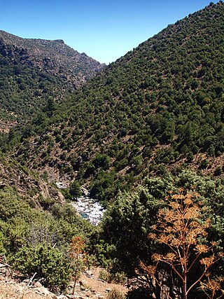
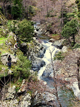
The Asco is a small river in the department of Haute-Corse, Corsica, France. It is a tributary of the Golo. The river rises in the Monte Cinto massif among some of the highest mountains of Corsica, passes a ski resort and the old village of Asco and cuts through a dramatic 4 kilometres (2.5 mi) gorge before joining the Golo.

<span class="mw-page-title-main">Fango (river)</span> River in the department of Haute-Corse, Corsica

The Fango is a small coastal river in the department of Haute-Corse, Corsica, France. The Fango Valley was designated a biosphere reserve in 1977. It holds flora and fauna representative of all regions of Corsica from the coast to the highest mountains.

<span class="mw-page-title-main">Erco (river)</span> River in France

The Erco is a stream in the department of Haute-Corse, Corsica, France. It is a tributary of the Golo.

<span class="mw-page-title-main">Capo al Berdato</span> Mountain in France

Capo al Berdato is a mountain in the department of Haute-Corse on the island of Corsica, France. It is in the Monte Cinto massif.

<span class="mw-page-title-main">Punta Minuta</span>

Punta Minuta is a 2,556 metres (8,386 ft) mountain in the department of Haute-Corse on the island of Corsica, France. It is in the Monte Cinto massif.

<span class="mw-page-title-main">Paglia Orba</span>

The Paglia Orba is a mountain peak in the Monte Cinto massif in Corsica. It rises to an altitude of 2,525 metres (8,284 ft), between the valleys of the Golo and the Cavicchia. Relatively isolated, this peak, notable for its characteristic tooth-shaped silhouette, dominates the Fango Valley and the west coast of the island.

<span class="mw-page-title-main">Col de San Quilico</span> Mountain pass in Corsica, France

The Col de San Quilico or collo di San Quilico is a mountain pass in the Haute-Corse department of Corsica, France. It is a road pass on Territorial Route 20, between Corte and Ponte Leccia (Morosaglia).

References

  1. "Répertoire national des élus: les maires". data.gouv.fr, Plateforme ouverte des données publiques françaises (in French). 2 December 2020.
  2. "Populations légales 2021" (in French). The National Institute of Statistics and Economic Studies. 28 December 2023.
  3. Google Maps
  4. FactSheet: Wildlife endemic to Corsica from the National Board of Forestry (in French)
  5. "Топографическая карта Corsica, высота, рельеф". topographic-map.com (in Russian). Retrieved 5 June 2021.
  6. 1 2 Corsica in Antiquity and the High Middle Ages - Xavier Poli, Fontemoing 1907 (in French)
  7. ADECEC Elements for a Dictionary of Proper Names Archived 2012-01-26 at the Wayback Machine (in French)
  8. The Grand Revolt of Corsica against the Genovese 1729-1769 Archived 2011-10-04 at the Wayback Machine , Antoine Dominique Monti, ADECEC, 1979 (in French)
  9. List of Mayors of France (in French)
  10. Population en historique depuis 1968, INSEE