
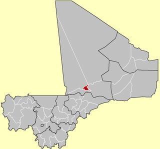
Bafoulabé Cercle is an administrative subdivision of the Kayes Region of Mali. The administrative center (chef-lieu) is the town of Bafoulabé. In the 2009 census the population of the cercle was 233,926.
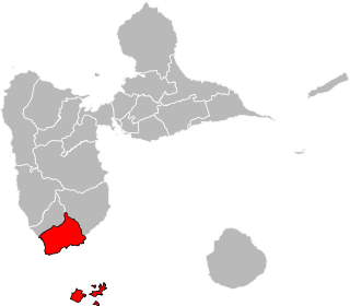
The canton of Trois-Rivières is an administrative division in the department of Guadeloupe. Its borders were modified at the French canton reorganisation which came into effect in March 2015. Its seat is in Trois-Rivières.

Wolonkoto is a small department or commune of Léraba Province in south-western Burkina Faso. Its capital lies at the town of Wolonkoto. According to the 1996 census the department has a total population of 3,687.

Nioro Cercle is an administrative subdivision of the Kayes Region of Mali. Its administrative center (chef-lieu) is the town of Nioro du Sahel. The commune is on the Mauritanian border and has long been a major stop on the trans-Saharan trade.
Gogui is a small town and rural commune in the Cercle of Nioro in the Kayes Region of western Mali. The town is on the frontier with Mauritania.

Bandiagara Cercle is an administrative subdivision of the Mopti Region of Mali. The administrative center (chef-lieu) is the town of Bandiagara.

Bankass Cercle is an administrative subdivision of the Mopti Region of Mali. The administrative center (chef-lieu) is at the town of Bankass.

Koro Cercle is an administrative subdivision of the Mopti Region of Mali. The administrative center is the town of Koro.
Diré Cercle is an administrative subdivision of the Tombouctou Region of Mali. The administrative center (chef-lieu) is the town of Diré.

Gourma-Rharous Cercle is an administrative subdivision of the Tombouctou Region of Mali. The administrative center is the town of Gourma-Rharous.

Niafunké Cercle is an administrative subdivision of the Tombouctou Region of Mali. The administrative center (chef-lieu) is the town of Niafunké. In the 2009 census the cercle had a population of 184,285. The Niger River runs for 100 km through the cercle.

Timbuktu Cercle is an administrative subdivision of the Tombouctou Region of Mali. It is the largest cercle by area in the whole of Mali. The capital lies at the city of Timbuktu. The cercle is divided into Rural and Urban Communes, and below this, quarters/villages. In the 2009 census the cercle had a population of 124,546.
Allahina is a small town and rural commune in the Cercle of Nara in the Koulikoro Region of south-western Mali. The town lies 31 km south of the Mauritanian border and 156 km west of Nara, the administrative centre of the cercle. The commune, which includes the town and seven of the surrounding villages, had a population of 11,683 in the 2009 census.
N'Golodiana is a commune in the Cercle of Kolondieba in the Sikasso Region of southern Mali. The principal town lies at Toutiala. In 1998 the commune had a population of 4435.
Dogofry is a village and a rural commune in the Cercle of Niona in the Ségou Region of southern-central Mali. The commune covers an area of approximately 3,820 square kilometers and is bordered to the north by the Republic of Mauritania, to the east by the commune of Nampalari, to the southeast by the commune of Diabaly, to the southwest by the commune of Sokolo and to the west by the commune of Guiré in the Cercle of Nara. It includes 19 villages, and had a population of 34,057 in the 2009 census. The south of the commune includes a region irrigated as part of the Office du Niger scheme. The village of Dogofry lies in this irrigated area, about 60 km north of Niono, to the west of the Fala de Molodo and the Distributeur de Kogoni.
Kassorola is a commune in the Cercle of San in the Ségou Region of Mali. The administrative center is the town of Nianasso. In a 2009 census, this regions total population was 16,275.
Kirchamba is a village and commune of the Cercle of Diré in the Tombouctou Region of Mali. As of 1998 the commune had a population of 2,305.
Kondi is a village and commune of the Cercle of Diré in the Tombouctou Region of Mali. As of 1998 the commune had a population of 3,269.
Kaneye is a village and commune of the Cercle of Goudam in the Tombouctou Region of Mali. As of 1998 the commune had a population of 2,418.
Tin Aicha is a village and commune of the Cercle of Goudam in the Tombouctou Region of Mali. As of 1998 the commune had a population of 3,940.
