Related Research Articles
Organic fertilizers are fertilizers derived from animal matter, animal excreta (manure), human excreta, and vegetable matter. Naturally occurring organic fertilizers include animal wastes from meat processing, peat, manure, slurry, and guano.

Zhombe is a rural communal area in Kwekwe District, Midlands Province, Zimbabwe.It is an area of mixed Shona and Northern Ndebele People.It lies along Mnyathi Border line between Midlands and Mashonaland Provinces. There are a few commercial farms within its borders and a handful of resettlement areas. Most of it is within the Zhombe Constituency. Its administrative centre is the Zhombe Joel Growth Point, and it is under the Zibagwe Rural District Council.
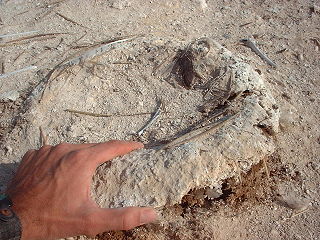
Guano is the accumulated excrement of seabirds and bats. As a manure, guano is a highly effective fertilizer due to its exceptionally high content of nitrogen, phosphate, and potassium: key nutrients essential for plant growth. Guano was also, to a lesser extent, sought for the production of gunpowder and other explosive materials.
The Bat Cave guano mine, located in the western Grand Canyon of Arizona at river mile 266, 800 feet (240 m) above Lake Mead, was an unusual, expensive and noteworthy mining operation. The natural cave was a bat habitat and contained an accumulation of guano.
Taranakite is a hydrated alkali iron-aluminium phosphate mineral with chemical formula (K,Na)3(Al,Fe3+)5(PO4)2(HPO4)6·18H2O. It forms from the reaction of clay minerals or aluminous rocks with solutions enriched in phosphate derived from bat or bird guano or, less commonly, from bones or other organic matter. Taranakite is most commonly found in humid, bat inhabited caves near the boundary of guano layers with the cave surface. It is also found in perennially wet coastal locations that have been occupied by bird colonies. The type location, and its namesake, the Sugar Loaf Islands off Taranaki, New Zealand, is an example of a coastal occurrence.

Columbina Rural Service Center is a populated place in Zhombe. It is 95km northwest of Kwekwe and 67km southwest of Kadoma.
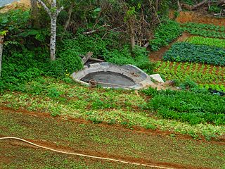
Ngondoma Irrigation Scheme is located in Zhombe, Kwekwe District in Zimbabwe's Agro-Ecological Region Three. The average annual rainfall for the location is 550 mm. The scheme area is 44.4 4 hectares. Of the 179 farmers in the scheme, 134 are women. It comprises members from various villages, including villagers from Chief Njelele side, Gokwe District on the other side of Ngondoma River.
Empress Mine Township is a populated place in the area formerly known as Salakuhle in Zhombe Communal Land, Kwekwe District of the Midlands Province in Zimbabwe. It is Zhombe's largest growth point yet officially it is rated second after Zhombe Joel, the current Zhombe District capital.
Commoner, Zimbabwe is a populated place and a place where highly deformed and folded quartz reef structure gold ore is extracted. It is about 50 km west-southwest of Kadoma by air and 68 km by road. 67 km north-west of Kwekwe by air and 96 km by road. It is in Zhombe _ Kwekwe District, _ Midlands Province _ Zimbabwe. Commoner is not to be confused with Commoner Gold Mine near Kadoma in Mashonaland West Province

Ngondoma Dam is a dam on the Ngondoma River located 500 meters west of the Empress Mine Township in the Midlands Province of Zimbabwe. The dam is 67 kilometers northwest of the Kwekwe and 54 km southwest of Kadoma.

Ngondoma River is a river in Zhombe Communal Land, Kwekwe District in the Midlands province of Zimbabwe.
Nyaradzo Secondary School is a school in Zhombe Empress Mine Ward in the Midlands Province of Zimbabwe.

Mabura Ward is ward number 6 of the 33 wards in Zibagwe Rural District Council of Kwekwe District. It is in Zhombe Communinal Land in Midlands Province of Zimbabwe. It is 100 km north-west-north of Kwekwe and 73 km south-west of Kadoma. Its center is at Bee Mine Township but the sitting councillor operates from Samambwa Township.
Gwesela West is ward number 9 of the 33 wards in Zibagwe Rural District Council of Kwekwe District. Its center is at Senkwasi Irrigation Scheme 14.5 km north east of Zhombe Joel and 14.5 km south of Columbina Rural Service Center.
Senkwasi Irrigation Scheme is a cultivated area in Gwesela West 55.5 km northwest of Kwekwe in Chief Gwesela's area of jurisdiction. It is 14.6 km northeast of Zhombe Joel.
Donjane is ward 32 of the 33 wards in Zibagwe Rural District Council under Kwekwe District. It is in Zhombe-East in the Midlands.
Bee Mine Secondary School is a co-educational school in Zhombe Communal Land, Kwekwe District.
Samambwa Secondary School is a rural co-educational secondary school in Mabura ward of Kwekwe District.
Kwekwe-Gokwe Highway or the R84-7 Highway is an all-weather bitumen macadam highway in Zimbabwe running from Kwekwe to Gokwe passing through Zhombe. as a trunk road it is officially the P11 Highway
Exchange Irrigation Scheme is a 165 hectare irrigated arable land in Zhombe Communal Land but in Silobela Constituency in Kwekwe District of the Midlands Province of Zimbabwe. It is 37 km southwest of Zhombe Joel, 83 km northwest of Kwekwe and 25 km north of Crossroads DSC.
References
- 1 2 Mark Mhukayesango (11 November 2015) Compound D Substitute Discovered In Zhombe Radio VOP. National News. Retrieved 7 November 2015.
- 1 2 Tinomuda Chakanyuka. (May 2015) Zhombe pins hope on bat poop The Sunday News. Opinion & Analysis. Retrieved 7 December 2015.
- ↑ New ZIANA. Paragraph 3. 16 April 2013 Fertiliser plant spreads wings to Bindura....Mabura Caves in the Zhombe area of the Midlands Province. The Herald. Business. Retrieved 16 December 2015
- ↑ Cartographic.info Line 565 List of places in Midlands, Zimbabwe Retrieved 7 December 2015
- ↑ Zimbabwe: National Museums and Monuments Act.pdf | Part 1, PRELIMINARY | Interpretation 2b. Zimbabwe: National Museums and Monuments Act. Zimbabwe Act of Parliament | Title 25. (Chapter 25:11).
- ↑ Chrispen Chauke. Paragraph 3.2 "Mabura Caves & Chinhoyi Caves" According to the National Mesiums and Monuments Act, Chapter 25/11, the cave is a monument..... Archived 2015-12-22 at the Wayback Machine African Immovable Cultural Heritage - Zimbabwe.pdf | Paragraph 3. Geological/Natural Monuments. Retrieved 16 December 2016.
- ↑ All About Countries Guano Cave Archived 2015-12-22 at the Wayback Machine
- ↑ All-about-countries Places Around Guano Cave_ Samambwa School (6.49km) Archived 2015-12-22 at the Wayback Machine Retrieved 16 December 2015
- ↑ Barber B 1991 for crops/56zimbabwe.PDF | Rocks for Crops [ permanent dead link ] Phosphate resources of Zimbabwe. Fert. Res. 30:247-278
- ↑ Rocks for Crops pp323_
Capital: Kwekwe | |
| Dams/reservoirs | |
| Rivers | |
| Highways/roads | |
| Museums/monuments | |
| Settlements | • Redcliff • Munyati • Silobela • Zhombe • Empress Mine • Commoner, Empress • Columbina Rural Service Center • Amaveni • Chicago • Mbizo |
| Health centres | |
| Irrgation schemes | |
| Education | |
| Culture and sport | |
| Notable people | • Blessing Chebundo • Emmerson Mnangagwa • Tongai Moyo • Learnmore Jongwe • Sam Levy • Norman Featherstone • Ronald Benade • Travis Friend • Michael Chinouya • Terry Duffin • Ahmed Esat • Chris Duckworth • Henry Madzorera • Charles Coventry (umpire) • Norman Featherstone • Charles Mudede • Morgan Mahanya |
| Constituencies | |
| Industries | |
| Aviation | |
| Mines | |