
Kennebec County is a county located in the South-central portion of the U.S. state of Maine. At the 2020 census, the population was 123,642. Its county seat is Augusta, the state capital. The county was established on February 20, 1799, from portions of Cumberland and Lincoln Counties. The name Kennebec comes from the Eastern Abenaki /kínipekʷ/, meaning "large body of still water, large bay."

Franklin County is a county located in the state of Maine, United States. As of the 2020 census, the population was 29,456, making it the second-least populous county in Maine. Its county seat is Farmington. The county was established on May 9, 1838, and named for Benjamin Franklin.
Androscoggin County is a county in the U.S. state of Maine. As of the 2020 census, the county's population was 111,139. Its county seat is Auburn and its most populous city is Lewiston.
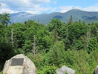
Mount Franklin is a mountain in Coös County, New Hampshire, United States. The mountain is named after Benjamin Franklin and is part of the Presidential Range of the White Mountains. Note that Ben Franklin was not a president. Mount Franklin is flanked to the northeast by Mount Monroe, and to the southwest by Mount Eisenhower.
Spaulding Mountain is a mountain located in Franklin County, Maine. Spaulding Mountain is flanked to the northeast by Sugarloaf Mountain, and to the southeast by Mount Abraham.
Kennebago Divide is a mountain located in Maine's Franklin and Oxford counties. It is also known as North Peak of Kennebago Divide. Its highest peak is in Franklin County, about 1.5 miles (2.4 km) southeast of the Canada–United States border with Québec. Kennebago Divide is flanked to the northeast by White Cap Mountain, and to the south by Snow Mountain.

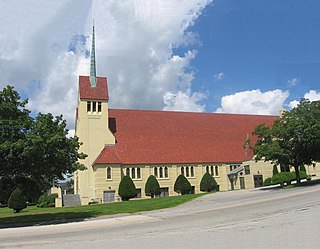
This is a list of the National Register of Historic Places listings in Franklin County, Maine.
The South Branch Moose River is a tributary of the Moose River in Franklin County, Maine. Its source on Caribou Mountain is about 1.5 miles (2 km) from the Canada–United States border, in Skinner. From there, the river winds generally north for 11.0 miles (17.7 km) to its confluence with the main stream of the Moose River in Lowelltown.
The West Branch Carrabassett River is a short tributary of the Carrabassett River in Franklin County, Maine. From the confluence of Quick Stream with a small stream in Salem, the river runs 11.1 miles (17.9 km) northeast to its mouth in Kingfield.
The West Branch Moose River is a short tributary of the South Branch Moose River in Franklin County, Maine. Its source is on Caribou Mountain in Merrill Strip, about 2,000 feet (600 m) from the Canada–United States border, which runs along the height of land between the watersheds of the Kennebec River in Maine and the Chaudière River in Quebec. From there, the river runs 5.9 miles (9.5 km) northeast to its confluence with the Moose River's South Branch in Skinner.

The 1988 United States presidential election in Maine took place on November 8, 1988, as part of the 1988 United States presidential election, which was held throughout all 50 states and D.C. Voters chose four representatives, or electors to the Electoral College, who voted for president and vice president.

The 1940 United States presidential election in Vermont took place on November 5, 1940, as part of the 1940 United States presidential election which was held throughout all contemporary 48 states. Voters chose three representatives, or electors to the Electoral College, who voted for president and vice president.

The 1936 United States presidential election in Vermont took place on November 3, 1936, as part of the 1936 United States presidential election which was held throughout all contemporary 48 states. Voters chose three representatives, or electors to the Electoral College, who voted for president and vice president.

The 1932 United States presidential election in Vermont took place on November 8, 1932, as part of the 1932 United States presidential election which was held throughout all contemporary 48 states. Voters chose three representatives, or electors to the Electoral College, who voted for president and vice president.

The 1852 United States presidential election in Maine took place on November 2, 1852, as part of the 1852 United States presidential election. Voters chose eight representatives, or electors to the Electoral College, who voted for President and Vice President.

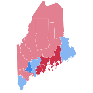
The 1912 United States presidential election in Maine took place on November 5, 1912, as part of the 1912 United States presidential election which was held throughout all contemporary 48 states. Voters chose six representatives, or electors to the Electoral College, who voted for president and vice president. Maine was won by the Democratic nominees, New Jersey Governor Woodrow Wilson and Indiana Governor Thomas R. Marshall. Wilson and Marshall defeated incumbent President William Howard Taft, and his running mate Vice President James S. Sherman and Progressive Party candidates, former President Theodore Roosevelt and his running mate California Governor Hiram Johnson.

The 1920 United States presidential election in Maine took place on November 2, 1920, as part of the 1920 United States presidential election which was held throughout all contemporary 48 states. Voters chose six representatives, or electors to the Electoral College, who voted for president and vice president.

The 1936 United States presidential election in Maine was held on November 3, 1936 as part of the 1936 United States presidential election. The state voters chose five electors to the Electoral College, who voted for president and vice president.
The 1940 United States presidential election in Maine took place on November 5, 1940. All contemporary 48 states were part of the 1940 United States presidential election. State voters chose five electors to the Electoral College, which selected the president and vice president. Maine was won by Republican businessman Wendell Willkie of New York, who was running against incumbent Democratic President Franklin D. Roosevelt of New York. Willkie ran with Senator Charles L. McNary of Oregon while Roosevelt ran with Henry A. Wallace of Iowa.

The 1964 United States presidential election in Maine took place on November 3, 1964, as part of the 1964 United States presidential election, which was held throughout all fifty states and D.C. Voters chose four representatives, or electors to the Electoral College, who voted for president and vice president.

