Carrabassett Valley, Maine

Last updated

Carrabassett Valley, Maine
Motto: 
"From Here On Out Your Life Will Never Be The Same"
USA Maine location map.svg
Red pog.svg
Carrabassett Valley
Usa edcp location map.svg
Red pog.svg
Carrabassett Valley
Coordinates: 45°4′25″N70°15′42″W / 45.07361°N 70.26167°W / 45.07361; -70.26167
Country United States
State Maine
County Franklin
VillagesBigelow
Carrabassett
Records
Area
[1]
  Total77.62 sq mi (201.03 km2)
  Land77.48 sq mi (200.67 km2)
  Water0.14 sq mi (0.36 km2)
Elevation
1,795 ft (547 m)
Population
 (2020)
  Total673
  Density9/sq mi (3.4/km2)
Time zone UTC-5 (Eastern (EST))
  Summer (DST) UTC-4 (EDT)
ZIP code
04947
Area code 207
FIPS code 23-10740
GNIS feature ID0582391
Website www.carrabassettvalley.org

Carrabassett Valley is a town in Franklin County, Maine, United States. The population was 673 at the 2020 census. [2]

Contents

Geography

According to the United States Census Bureau, the town has a total area of 77.62 square miles (201.03 km2), of which 77.48 square miles (200.67 km2) is land and 0.14 square miles (0.36 km2) is water. [1] It is named after the Carrabassett River, which flows through the town. The Appalachian Trail crosses the western side of the town, climbing the slopes of Sugarloaf Mountain and the summit of Crocker Mountain.

Skiing

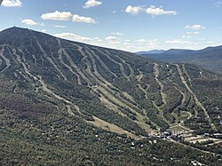
Carrabassett Valley is home to Sugarloaf, a major ski resort and Carrabassett Valley Academy, a ski and snowboard academy. [3]

Demographics

Historical population
CensusPop.Note
1980 107
1990 325203.7%
2000 39922.8%
2010 78195.7%
2020 673−13.8%
U.S. Decennial Census [4]

2010 census

As of the census [5] of 2010, there were 781 people, 373 households, and 219 families living in the town. The population density was 10.1 inhabitants per square mile (3.9/km2). There were 2,103 housing units at an average density of 27.1 per square mile (10.5/km2). The racial makeup of the town was 98.1% White, 0.1% Native American, 0.5% Asian, and 1.3% from two or more races. Hispanic or Latino of any race were 0.5% of the population.

There were 373 households, of which 21.2% had children under the age of 18 living with them, 53.1% were married couples living together, 3.8% had a female householder with no husband present, 1.9% had a male householder with no wife present, and 41.3% were non-families. 32.7% of all households were made up of individuals, and 7% had someone living alone who was 65 years of age or older. The average household size was 2.06 and the average family size was 2.62.

The median age in the town was 50 years. 16.4% of residents were under the age of 18; 4% were between the ages of 18 and 24; 18.2% were from 25 to 44; 46.6% were from 45 to 64; and 14.9% were 65 years of age or older. The gender makeup of the town was 52.8% male and 47.2% female.

2000 census

As of the census [6] of 2000, there were 399 people, 179 households, and 110 families living in the town. The population density was 5.2 inhabitants per square mile (2.0/km2). There were 1,675 housing units at an average density of 21.6 per square mile (8.3/km2). The racial makeup of the town was 99.00% White, 0.25% Asian, and 0.75% from two or more races. Hispanic or Latino of any race were 0.75% of the population.

There were 179 households, out of which 25.7% had children under the age of 18 living with them, 52.5% were married couples living together, 5.0% had a female householder with no husband present, and 38.5% were non-families. 27.4% of all households were made up of individuals, and 4.5% had someone living alone who was 65 years of age or older. The average household size was 2.23 and the average family size was 2.71.

In the town, the population was spread out, with 20.1% under the age of 18, 7.8% from 18 to 24, 31.6% from 25 to 44, 31.8% from 45 to 64, and 8.8% who were 65 years of age or older. The median age was 40 years. For every 100 females, there were 111.1 males. For every 100 females age 18 and over, there were 112.7 males.

The median income for a household in the town was $45,357, and the median income for a family was $55,938. Males had a median income of $32,500 versus $28,750 for females. The per capita income for the town was $25,608. About 1.9% of families and 7.0% of the population were below the poverty line, including 3.9% of those under age 18 and 6.1% of those age 65 or over.
Related Research Articles

<span class="mw-page-title-main">Baldwin, Maine</span> Town in the state of Maine, United States

Baldwin is a town in Cumberland County, Maine, United States. The population was 1,520 at the 2020 census. It is part of the Portland–South Portland–Biddeford, Maine, metropolitan statistical area.

<span class="mw-page-title-main">Kingfield, Maine</span> Town in the state of Maine, United States

Kingfield is a town in Franklin County, Maine, United States. The population was 960 at the 2020 census. Kingfield, the primary village in the town, is a census-designated place.

Bradley is a town in Penobscot County, Maine, United States. It is part of the Bangor Metropolitan Statistical Area. The population was 1,532 at the 2020 census. The village of Bradley is in the northwestern corner of the town.

Detroit is a town in Somerset County, Maine, United States. The population was 885 at the 2020 census.

Embden is a town in Somerset County, Maine, United States. The population was 902 at the 2020 census.

<span class="mw-page-title-main">New Portland, Maine</span> Town in the state of Maine, United States

New Portland is a town in Somerset County, Maine, United States. It is perhaps best known for its Wire Bridge, a cable suspension bridge completed in 1866 that is the last remaining bridge of its type in Maine, and possibly the U.S. Much of North New Portland's Main Street burned to the ground in the fire of 1919, including a hotel. The annual town fair draws large crowds from around, and is held in September. The population was 765 at the 2020 census. The town was given to the residents of Falmouth by the Massachusetts legislature to repay them for their loss when the British fleet burned Falmouth in 1775.

Cooper is a town in Washington County, Maine, United States. The community was named after General John Cooper, a landowner. The population was 168 at the 2020 census.

<span class="mw-page-title-main">Cutler, Maine</span> Town in the state of Maine, United States

Cutler is a town in Washington County, Maine, United States. The town was named after Joseph Cutler, an early settler, who hailed from Newburyport, Massachusetts. The population was 524 at the 2020 census.

Meddybemps is a town in Washington County, Maine, United States. The population was 139 at the 2020 census.

<span class="mw-page-title-main">Kitzmiller, Maryland</span> Town in Maryland, United States

Kitzmiller is a town in Garrett County, Maryland, United States. The population was 321 at the 2010 census.

<span class="mw-page-title-main">Stratford, New Hampshire</span> Town in New Hampshire, United States

Stratford is a town located on the Connecticut River in Coös County, New Hampshire, United States. The population was 662 at the 2020 census, down from 746 at the 2010 census. Within the town are the villages of North Stratford, Stratford Hollow, and Beatties. U.S. Route 3 passes through the center of town, as does the St. Lawrence and Atlantic Railroad, formerly a part of the Grand Trunk Railway.

<span class="mw-page-title-main">Tuscarawas, Ohio</span> Village in Ohio, United States

Tuscarawas, originally Trenton, is a village in Tuscarawas County, Ohio, United States. The population was 1,035 at the 2020 census.

<span class="mw-page-title-main">Black Creek Township, Pennsylvania</span> Township in Pennsylvania, United States

Black Creek Township is a township in Luzerne County, Pennsylvania, United States. The population was 1,904 as of the 2020 census.

<span class="mw-page-title-main">Sugarloaf Township, Luzerne County, Pennsylvania</span> Township in Pennsylvania, United States

Sugarloaf Township is a townshipthat is located in Luzerne County, Pennsylvania, United States. The population was 3,879 at the time of the 2020 census.

<span class="mw-page-title-main">Junior, West Virginia</span> Town in West Virginia, United States

Junior is a town in Barbour County, West Virginia, United States, situated along the Tygart Valley River. The population was 384 at the 2020 census.

<span class="mw-page-title-main">Harman, West Virginia</span> Town in West Virginia, United States

Harman is a town in Randolph County, West Virginia, United States. The population was 96 at the 2020 census.

<span class="mw-page-title-main">Green Valley, Shawano County, Wisconsin</span> Town in Wisconsin, United States

Green Valley is a town in Shawano County, Wisconsin, United States. The population was 1,024 at the 2000 census. The census-designated place of Green Valley and unincorporated communities of Advance and Pulcifer are located in the town.

<span class="mw-page-title-main">Tower City, North Dakota</span> City in North Dakota, United States

Tower City is a city in Barnes and Cass counties in the State of North Dakota. The population was 268 at the 2020 census.

Sugarloaf is an unincorporated community residential area less than a mile south of Big Bear City and 8 miles from the eastern tip of Big Bear Lake in the San Bernardino Mountains of San Bernardino County, California. The area is primarily residential with a convenience store and a post office located at the center of the community. The residential area is set at an elevation of 7,096 feet at its center, whereas its extreme northern border is 6,998 feet above sea level and the southern tip sits at 7,218 feet above sea level. There is no municipal organization for the area, and all fire, water, and police service is provided by San Bernardino County. The ZIP code for the community is 92386, the area code 909, and the population is 1,816. Big Bear High School is located in the northern part of the community.

<span class="mw-page-title-main">Anson, Maine</span> Town in the state of Maine, United States

Anson is a town in Somerset County, Maine, United States. The population was 2,291 at the time of the 2020 census. It includes the villages of Anson and North Anson.

References

  1. 1 2 "US Gazetteer files 2010". United States Census Bureau . Retrieved December 16, 2012.
  2. "Census - Geography Profile: Carrabassett Valley town, Franklin County, Maine" . Retrieved January 23, 2022.
  3. "CVA | Private Boarding School | Ski & Snowboard | Maine". www.gocva.com.
  4. "Census of Population and Housing". Census.gov. Retrieved June 4, 2015.
  5. "U.S. Census website". United States Census Bureau . Retrieved December 16, 2012.
  6. "U.S. Census website". United States Census Bureau . Retrieved January 31, 2008.