Malheur City, Oregon | |
|---|---|
 Malheur City  Malheur City | |
| Coordinates: 44°24′47″N117°43′30″W / 44.41306°N 117.72500°W | |
| Country | United States |
| State | Oregon |
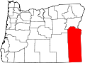
| County | Malheur |
| Elevation | 3,940 ft (1,200 m) |
| Time zone | UTC-8 (Pacific (PST)) |
| • Summer (DST) | UTC-7 (PDT) |
| GNIS feature ID | 1161431 [1] |
Malheur City is a ghost town in Malheur County, Oregon, United States, situated along Willow Creek. [2] The town was established in 1863 after miners struck gold in the nearby El Dorado mine. [2] Originally located in Baker County, Malheur City became part of Malheur County after the county's formation in 1887. [2] The town became unpopulated around 1911 after mining operations slowed in the area. [2] On August 16, 1957, a brushfire burned all of the town's remaining wooden structures, leaving only stone foundations. [2]