Basque, Oregon | |
|---|---|
 Basque  Basque | |
| Coordinates: 42°24′39″N117°52′07″W / 42.41083°N 117.86861°W | |
| Country | United States |
| State | Oregon |
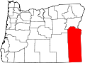
| County | Malheur |
| Elevation | 4,459 ft (1,359 m) |
| Time zone | UTC-8 (Pacific) |
| • Summer (DST) | UTC-7 (Pacific) |
| Area code | 541 |
| GNIS feature ID | 1136038 [1] |
Basque is an unincorporated community in Malheur County, Oregon, United States. [1] It lies along U.S. Route 95 about halfway between Burns Junction and McDermitt. [2] Basque migrants, many of them sheepherders, settled in remote parts of southeastern Oregon between the 1880s and the 1930s. [3]