Annex, Oregon

Last updated

Annex, Oregon
Annex Oregon.jpg
The town of Annex, Oregon
USA Oregon location map.svg
Red pog.svg
Annex, Oregon
Usa edcp location map.svg
Red pog.svg
Annex, Oregon
Coordinates: 44°14′25″N116°59′04″W / 44.24028°N 116.98444°W / 44.24028; -116.98444
Country United States
State Oregon
County Malheur
Area
[1]
  Total2.46 sq mi (6.37 km2)
  Land2.46 sq mi (6.37 km2)
  Water0.00 sq mi (0.00 km2)
Elevation
2,103 ft (641 m)
Population
 (2020) [2]
  Total225
  Density91.50/sq mi (35.32/km2)
Time zone UTC-7 (Mountain (MST))
  Summer (DST) UTC-6 (MDT)
ZIP code
97914 [3]
Area codes 541 & 458
GNIS feature ID1129770 [4]

Annex is an unincorporated community and census-designated place in Malheur County, Oregon, United States. Its population was 235 as of the 2010 census. [5] 
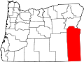
The community is located on the south bank of the Snake River across from Weiser, Idaho; a bridge carrying U.S. Route 95 Spur connects the two.

Contents

Geography

According to the U.S. Census Bureau, the community has an area of 2.461 square miles (6.37 km2), all of it land. [5]

Demographics

Historical population
CensusPop.Note
2020 225
U.S. Decennial Census [6] [2]

Education

Annex is within the Annex School District 29. [7] It operates a K-8 school called the Annex Charter School. [8] In 1967 the Annex School was having a new building established. [9]

As of 1998 students who graduate from Annex attend Weiser High School, of the Weiser School District, in Weiser, Idaho. [10] In 1958, there were 46 students at Weiser High who lived in Annex. [11]

The section of Malheur County in which this community is located in is in the Treasure Valley Community College district. [12]

Related Research Articles

<span class="mw-page-title-main">Malheur County, Oregon</span> County in Oregon, United States

Malheur County is one of the 36 counties in the U.S. state of Oregon. As of the 2020 census, the population was 31,571. Its county seat is Vale, and its largest city is Ontario. The county was named after the Malheur River, which runs through the county. The word "malheur" is French for misfortune or tragedy. Malheur County is included in the Ontario, Oregon Micropolitan Statistical Area, which is also included in the Boise Combined Statistical Area. It is included in the eight-county definition of Eastern Oregon.

<span class="mw-page-title-main">Harney County, Oregon</span> County in Oregon, United States

Harney County is one of the 36 counties in the U.S. state of Oregon. As of the 2020 census, the population was 7,495, making it the sixth-least populous county in Oregon. The county seat is Burns. Established in 1889, the county is named in honor of William S. Harney, a military officer of the period, who was involved in the Pig War and popular in the Pacific Northwest.

<span class="mw-page-title-main">Baker County, Oregon</span> County in Oregon, United States

Baker County is one of the 36 counties in the U.S. state of Oregon. As of the 2020 census, the population was 16,668. The county seat and largest city is Baker City. The county was organized on September 22, 1862, when a portion of Wasco County was partitioned off. The new county's area was reduced in 1864 when Union County was partitioned off, and again in 1887 when Malheur County was partitioned off. The county's lines were last adjusted in 1901 when a parcel was added to the county.

<span class="mw-page-title-main">Washington County, Idaho</span> County in Idaho, United States

Washington County is a county in the U.S. state of Idaho. As of the 2020 census, the population was 10,500. The county seat and largest city is Weiser, with over half of the county's population. The county was established in 1879 when Idaho was a territory and named after U.S. President George Washington.

<span class="mw-page-title-main">Canyon County, Idaho</span> County in Idaho, United States

Canyon County is located in the U.S. state of Idaho. As of the 2020 Census, the population was 231,105, making it the second-most populous county in Idaho. The county seat is Caldwell, and its largest city is Nampa. Canyon County is part of the Boise metropolitan area.

<span class="mw-page-title-main">Weiser, Idaho</span> City in Idaho, United States

Weiser is a city in the rural western part of the U.S. state of Idaho and the county seat of Washington County. With its mild climate, the city supports farm, orchard, and livestock endeavors in the vicinity. The city sits at the confluence of the Weiser River with the great Snake River, which marks the border with Oregon. The population was 5,507 at the 2010 census.

<span class="mw-page-title-main">McDermitt, Nevada and Oregon</span> Unincorporated community in the state of Nevada, United States

McDermitt is an unincorporated community straddling the Nevada–Oregon border, in Humboldt County, Nevada, and Malheur County, Oregon, United States. McDermitt's economy has historically been based on mining, ranching, and farming. The last mining operation closed in 1990, resulting in a steady decline in population.

<span class="mw-page-title-main">Adrian, Oregon</span> City in Oregon, United States

Adrian is a city in Malheur County, Oregon, United States, near the confluence of the Snake River and the Owyhee River. The population was 177 at the 2010 census. It is part of the Ontario, OR–ID Micropolitan Statistical Area.

<span class="mw-page-title-main">Jordan Valley, Oregon</span> City in Oregon, United States

Jordan Valley is a city in Malheur County, Oregon, United States. It is part of the Ontario, OR–ID Micropolitan Statistical Area. The city lies along Jordan Creek, a tributary of the Owyhee River; the creek is named for a 19th-century prospector, Michael M. Jordan. The population was 181 at the 2010 census.

<span class="mw-page-title-main">Nyssa, Oregon</span> City in Oregon, United States

Nyssa is a city in Malheur County, Oregon, United States. The population was 3,267 at the 2010 census. The city is located along the Snake River on the Idaho border, in the region of far eastern Oregon known as the "Treasure Valley". It is part of the Ontario, OR–ID Micropolitan Statistical Area.

<span class="mw-page-title-main">Ontario, Oregon</span> City in Oregon, United States

Ontario is the largest city in Malheur County, Oregon, United States. It lies along the Snake River at the Idaho border. The population was 11,366 at the 2010 census. The city is the largest community in the region of far eastern Oregon, also known as the Western Treasure Valley.

<span class="mw-page-title-main">Vale, Oregon</span> City in Oregon, United States

Vale is a city in and the county seat of Malheur County, Oregon, United States, about 12 miles (19 km) west of the Idaho border. It is at the intersection of U.S. Routes 20 and 26, on the Malheur River at its confluence with Bully Creek.

<span class="mw-page-title-main">Boise metropolitan area</span> Metropolitan statistical area in Idaho, United States

The Boise–Nampa, Idaho Metropolitan Statistical Area (MSA) is an area that encompasses Ada, Boise, Canyon, Gem, and Owyhee counties in southwestern Idaho, anchored by the cities of Boise and Nampa. It is the main component of the wider Boise–Mountain Home–Ontario, ID–OR Combined Statistical Area, which adds Elmore and Payette counties in Idaho and Malheur County, Oregon. It is the state's largest officially designated metropolitan area and includes Idaho's three largest cities: Boise, Nampa, and Meridian. Nearly 40 percent of Idaho's total population lives in the area.

<span class="mw-page-title-main">Drewsey, Oregon</span> Unincorporated community in the state of Oregon, United States

Drewsey is an unincorporated community in Harney County, in the U.S. state of Oregon. Drewsey is along the main stem of the Malheur River, about 45 miles (72 km) east of Burns, off U.S. Route 20. It has the ZIP Code of 97904.

<span class="mw-page-title-main">Crane, Oregon</span> Unincorporated community in the state of Oregon, United States

Crane is a census-designated place and unincorporated community in Harney County, Oregon, United States, northeast of Malheur Lake on Oregon Route 78. Its population was 116 at the 2020 census.

The Ontario Micropolitan Statistical Area, as defined by the United States Census Bureau, is an area consisting of two counties – one in southeastern Oregon and one in southwestern Idaho, anchored by the city of Ontario.

<span class="mw-page-title-main">Juntura, Oregon</span> Unincorporated community in the state of Oregon, United States

Juntura is an unincorporated community in Malheur County, Oregon, United States on U.S. Route 20. The word juntura is Spanish for "juncture", and the community was named for its proximity to the confluence of the Malheur River with the North Fork Malheur River. The name was probably selected by local settler B. L. Milligan, who arrived in the area in the 1880s and who later served as county school superintendent. Juntura post office was established in 1890 and is still operating. The community's development slowed after World War II, and on November 2, 1976, the town voted to disincorporate. Juntura is part of the Ontario micropolitan area.

<span class="mw-page-title-main">Huntington School District</span> Public school in Huntington, Oregon, United States

Huntington School is a public school in Huntington, Oregon, United States. Serving grades K-12, it is the only school in the Huntington School District 16J.

<span class="mw-page-title-main">National Weather Service Boise, Idaho</span> Weather Forecast Office of the National Weather Service

The National Weather Service Boise, Idaho is a weather forecast office responsible for weather forecasts, warnings and local statements as well as aviation weather forecasts and fire weather forecasts for 3 counties in Southeast Oregon and 14 counties in Southwest and South central Idaho. The U.S. Weather Bureau established an office in the Sonna Building on December 1, 1898. Since then, the U.S Weather Bureau office, now known as the National Weather Service forecast office gained forecast responsibility of Southern Idaho on June 22, 1970 which was expanded to the entire state of Idaho in 1973. After modernization in 1993, the forecast responsibility was changed to Southeast Oregon and Southwest Idaho. The current office in Boise maintains a WSR-88D (NEXRAD) radar system, 8 Automated airport weather station (ASOS) systems and Advanced Weather Interactive Processing System (AWIPS) that greatly improve forecasting in the region. Continuous weather observations have been maintained for the city of Boise since February 1, 1864 about 5 months after the U.S. Army established Fort Boise. The post surgeon for the U.S. Army took observations until July 1, 1877 when the U.S. Signal Service, established an office downtown. The Signal Office was discontinued on July 1, 1890.

Vale School District 84 is a school district headquartered in Vale, Oregon.

References

  1. "ArcGIS REST Services Directory". United States Census Bureau. Retrieved October 12, 2022.
  2. 1 2 "Census Population API". United States Census Bureau. Retrieved October 12, 2022.
  3. "Annex OR ZIP Code". zipdatamaps.com. 2023. Retrieved June 16, 2023.
  4. "Annex". Geographic Names Information System . United States Geological Survey, United States Department of the Interior.
  5. 1 2 "2010 Census Gazetteer Files - Places: Oregon". U.S. Census Bureau . Retrieved January 17, 2017.
  6. "Census of Population and Housing". Census.gov. Retrieved June 4, 2016.
  7. "2020 CENSUS - SCHOOL DISTRICT REFERENCE MAP: Malheur County, OR" (PDF). U.S. Census Bureau . Retrieved July 15, 2022.
  8. "Home". Annex Charter School. Retrieved July 15, 2022. 402 Annex Road | Ontario, Ore. 97914 - Despite the Ontario postal address, it is not in Ontario. Compare with the US Census Bureau school district map here.
  9. "16 East Oregon Schools Classified as 'Substandard'". The Idaho Sunday Statesman . Boise, Idaho. August 13, 1967. p. D1. - Clipping from Newspapers.com. See text detail
  10. "Home". Annex School District. February 24, 1999. Archived from the original on February 24, 1999. Retrieved July 17, 2022.
  11. "School Districts' Reorganization To Be Outlined". The Idaho Statesman . Boise, Idaho. August 9, 1958. p. 9 (of second section). - See clipping from Newspapers.com.
  12. "Oregon Community Colleges and Community College Districts" (PDF). Oregon Department of Community Colleges & Workforce Development . Retrieved July 17, 2022.