Provincial Trunk Highway 1 is Manitoba's section of the Trans-Canada Highway. It is a heavily used, 4-lane divided highway, with the exception of a short 18 km section in the southeastern corner of the province. It is the main link between southern Manitoba's largest cities, and also serves as the province's main transportation link to the neighbouring provinces of Saskatchewan and Ontario. The highway is the only major east-west divided highway in Manitoba, and carries a large majority of east-west traffic within and through the province. It has full freeway status sections at Portage la Prairie and Winnipeg. The total distance of the Trans-Canada Highway in Manitoba is approximately 490 km (300 mi).
Provincial Trunk Highway 16 (PTH 16) is a provincial highway in the Canadian province of Manitoba. It is the Manitoba section of the Yellowhead Highway, and also the Trans-Canada Highway Yellowhead section. The main purpose of this highway is to connect Winnipeg with other Canadian cities such as Saskatoon and Edmonton. The highway runs from Bloom at an intersection with the Trans-Canada Highway and Provincial Road 305 ten kilometres (6.2 mi) west of Portage la Prairie to the Saskatchewan boundary sixteen kilometres (9.9 mi) west of Russell, where it continues as Saskatchewan Highway 16.
Provincial Trunk Highway 4 is a provincial highway in the Canadian province of Manitoba. The highway connects the city of Selkirk to PTH 59, the main route to Grand Beach and cottage country on the east side of Lake Winnipeg.
Provincial Trunk Highway 11 (PTH 11) is a provincial primary highway located in the Eastman Region of the Canadian province of Manitoba. It runs from an intersection with PTH 59 near Victoria Beach to an intersection with PTH 1.

Carberry is a town in Westman Region of Manitoba, Canada. It is situated 3 kilometres (1.9 mi) south of the Trans-Canada Highway on Highway 5 in the Municipality of North Cypress – Langford, and has a population of 1,818 people.
Provincial Trunk Highway 5 is a provincial primary highway located in the Canadian province of Manitoba.

Provincial Trunk Highway 10 is a provincial primary highway located in the Canadian province of Manitoba.
Provincial Trunk Highway 44 is an east-west provincial highway in the Eastman Region of the Canadian province of Manitoba.

Provincial Trunk Highway 13 is a provincial highway in the Canadian province of Manitoba. It is an RTAC route capable of handling RTAC vehicles such as trucks, truck and pony trailers, trucks and full trailers, truck tractors, and semi-trailers, A-trains, B-trains, or C-trains. The route extends south to north from its junction with PTH 3 and PR 245 in Carman to its junction with PTH 1 and PR 430 north of Oakville. The northern terminus of PTH 13 is located between Portage la Prairie and Manitoba's capital city Winnipeg. The Central Manitoba Railway (CEMR) shortline rail intersects PTH 13 north of Carman, the Canadian Pacific Railway (CPR) intersects at Elm Creek, and the Canadian National Railway (CNR) at Oakville.

Provincial Trunk Highway 83 is a 402 kilometres (250 mi) long, major north-south highway that runs in the far western region of the Canadian province of Manitoba. It travels from the North Dakota border south of Melita, north through Virden, Birtle, Russell, and Roblin to its northern terminus with PTH 10 in the town of Swan River. Along with US 83, PTH 83 is part of a continuously numbered north-south highway in North America with a combined distance of 3,450 kilometres (2,140 mi).
Provincial Trunk Highway 20 is a provincial highway in the Canadian province of Manitoba. It runs from PTH 5 and PR 582 just south of Ochre River to PTH 10 in the village of Cowan. The highway provides an eastern alternative access option to Dauphin along with PTH 20A.
Provincial Trunk Highway 26, also known as Chemin Assiniboine Trail, is a provincial highway in the Canadian province of Manitoba. It is an east-west route that begins and ends at the Trans-Canada Highway. The western terminus is located near the interchange of PTH 1 and PTH 1A approximately 3 kilometres east of Portage la Prairie, while the eastern terminus is 3 kilometres southeast of St. François Xavier and 13 kilometres west of Winnipeg's Perimeter Highway. PTH 26 provides access to the small communities of St. François Xavier and Poplar Point. It serves as an alternative scenic route between Portage la Prairie and Winnipeg as it closely follows the Assiniboine River which flows south of the highway. The speed limit on this highway is 90 kilometres per hour (56 mph).
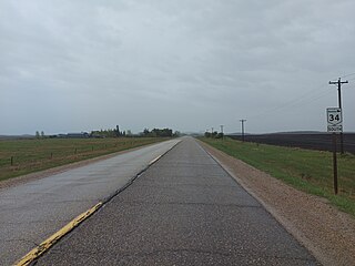
Provincial Trunk Highway 34 is a provincial primary highway located in the Canadian province of Manitoba. It runs from the U.S. border to PTH 16 at the town of Gladstone.
Provincial Road 457 is a provincial road in the southwest part of the Canadian province of Manitoba.
Provincial Road 344 is a very short provincial road in the Westman Region of the Canadian province of Manitoba. It connects the town of Wawanesa with PTH 2 on its western side.
Provincial Road 340 is a provincial road in the Westman Region of the Canadian province of Manitoba, connecting Wawanesa with Treesbank, Sprucewoods, Cottonwoods, and the Trans-Canada Highway at Douglas.

Provincial Road 331 is an east-west provincial road in the Central Plains Region of the Canadian province of Manitoba, connecting the city of Portage la Prairie and the town of Oakville via Newton.

Manitoba Provincial Road 258 is a former provincial road in the Canadian province of Manitoba.

Provincial Road 455 is a provincial road in the southwest part of the Canadian province of Manitoba.

Manitoba Provincial Road 468 is a provincial road in the southwestern section of the Canadian province of Manitoba.
