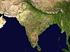
Himachal Pradesh is a state in the northern part of India. Situated in the Western Himalayas, it is one of the thirteen mountain states and is characterized by an extreme landscape featuring several peaks and extensive river systems. Himachal Pradesh is the northernmost state of India and shares borders with the union territories of Jammu and Kashmir and Ladakh to the north, and the states of Punjab to the west, Haryana to the southwest, Uttarakhand to the southeast and a very narrow border with Uttar Pradesh to the south. The state also shares an international border to the east with the Tibet Autonomous Region in China. Himachal Pradesh is also known as Dev Bhoomi, meaning 'Land of Gods' and Veer Bhoomi which means 'Land of the Brave'.

Dharamshala is the winter capital of Himachal Pradesh, India. It serves as administrative headquarters of the Kangra district after being relocated from Kangra, a city located 18 km (11 mi) away from Dharamshala, in 1855.

Kangra is the most populous district of the Indian state of Himachal Pradesh. Dharamshala is the administrative headquarters of the district.

Kangra is a city and a municipal council in Kangra district in the Indian state of Himachal Pradesh. It is also known as Nagarkot.

Pathankot is a city and the district headquarters of the Pathankot district in Punjab, India. Pathankot is the 6th most populous city of Punjab, after Ludhiana, Amritsar, Jalandhar, Patiala and Bathinda. Its local government is a municipal corporation.

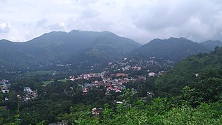
Palampur is a hill station and a municipal corporation situated in the Kangra District in the Indian state of Himachal Pradesh. It is surrounded by pine forests and flanked by the Dhauladhar ranges. There are numerous streams flowing from the mountains to the plains, from Palampur. The combination of greenery, snowclad mountains and water gives Palampur a distinctive look.

Nagrota Bagwan is a town and a municipal council in Kangra district in the Indian state of Himachal Pradesh. It is important town situated in Kangra valley around serene lap of Dhauladhar Mountain Range. It is a major market area with numerous stores and showrooms. Area also has an industrial area with small scale industries. There are various automobile showrooms around the town. It is located within center of 3 main towns of the valley: Dharamshala, Palampur and Kangra.
Nurpur is a city and a municipal council in Kangra district in the Indian state of Himachal Pradesh. It was formerly part of the Nurpur State since the 11th century AD. The capital of the state was at Pathankot formerly known as Paithan, now in Punjab.It got its name from wife of Mughal emperor Jahangir, Nur Jahan, when they visited Kangra (Nagarkot) after Jahangir's successful conquest of the Kangra Fort.
Sundar Nagar is a town and a municipal council in Mandi district in the Indian state of Himachal Pradesh. Formerly it was a princely state, known as Suket.

Tira Sujanpur, also known as Sujanpur Tira or Sujanpur Tihra, is a town and municipal council in the Hamirpur district of Himachal Pradesh. Founded in the 18th-century by the Katoch dynasty, the town is located midst the Himalayan foothills on the southern bank of the Beas River. It was one of the centers of Kangra-style miniature paintings and Hindu temples built in an unusual blend of conventional Nagara architecture shrines with Mughal architecture palace, the latter decorated with floral murals of legends from the Ramayana and the Mahabharata.
The development of tribal areas in Himachal Pradesh is one of the major steps taken by the state government for its economic development. The border districts of Kinnaur, Lahaul, Spiti and the Pangi and Bharmour tehsils of Chamba districts are the major tribal areas of the state. They are located near the borders of Tibet and Indian States of Jammu and Kashmir. Other backward areas include Shillai in Sirmaur district, and deep cut-off valleys in the Kullu and upper stretches of Kangra districts. Due to poor accessibility, life in these areas had grown in isolation.

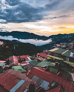
Kangra Valley is a river valley situated in the Western Himalayas. It lies in the state of Himachal Pradesh in India, and is a popular tourist destination. The Kangri dialect is spoken there. Dharamshala, the headquarters of Kangra district and the main city of the valley, lies on the southern spur of Dhauladhar.

The Kangra Valley Railway is a 2 ft 6 in gauge railway that runs from Pathankot, Punjab to Jogindernagar in Himachal Pradesh. It runs through the sub-Himalayan region of Kangra Valley and is 164 km (101.9 mi) long. It is on the UNESCO World Heritage Sites tentative list. The railway is part of the Firozpur division of Northern Railway. It is the longest Narrow Gauge line in India and also the longest 2 ft 6 in Gauge Railway in the World. The highest point on this line is Ahju station at an elevation of 1,290 meters (4,230 ft). There are 33 stops and 950 bridges.
Bhawarna is a town in Kangra district, Himachal Pradesh, India. 11 kilometres (6.8 mi) from Palampur. The postal code for Bhawarna is 176083.
Kunj Behari Lal Butail was an Indian National Congress leader, and a leading tea grower from Palampur, Kangra, Himachal Pradesh.
Tourism in Himachal Pradesh relates to tourism in the Indian state of Himachal Pradesh. This is popularly renowned for its Himalayan landscapes and popular hill-stations. Many outdoor activities such as rock climbing, mountain biking, paragliding, ice-skating, trekking, rafting, and heli-skiing are popular tourist attractions in Himachal Pradesh.

Joginder Nagar railway station is a railway station serving Joginder Nagar town, Himachal Pradesh in India. The station lies in the Kangra Valley Railway and under Firozpur railway division of Northern Railway zone of Indian Railways.It is a small railway station in Joginder Nagar in Mandi district of Himachal Pradesh.

Kangra tea is a tea from the Kangra district in Himachal Pradesh, India. Both black tea and green tea have been produced in the Kangra Valley since the mid-19th century. Kangra tea was given the Geographical Indication status in 2005.
Jawalamukhi Road railway station is a small railway station in Kangra district in the Indian state of Himachal Pradesh. The station lies on Pathankot–Jogindernagar narrow-gauge railway. This railway is also called Kangra Valley Railway. Jawalamukhi Road railway station is located at an altitude of 549 metres (1,801 ft) above mean sea level. It was allotted the railway code of JMKR under the jurisdiction of Firozpur railway division. This line was planned in 1926 and commissioned in 1929.
Palampur Himachal railway station is a small railway station in Kangra district in the Indian state of Himachal Pradesh. The station lies on Kangra Valley Railway. Palampur Himachal railway station is at an elevation of 1,119 metres (3,671 ft). It was allotted the railway code of PLMX under the jurisdiction of Firozpur railway division. The 610 mm -wide narrow gauge was opened for traffic in 1929. In 1929 the line was regauged to 762 mm -wide narrow gauge.