Marlin, Pennsylvania

Last updated
MarLin, Pennsylvania
CDP
Post Office, Marlin PA.JPG
Post Office in MarLin.
USA Pennsylvania location map.svg
Red pog.svg
MarLin, Pennsylvania
Location within the U.S. state of Pennsylvania
Coordinates: 40°40′50″N76°14′39″W / 40.68056°N 76.24417°W / 40.68056; -76.24417
Country United States
State Pennsylvania
County Schuylkill
Municipality Norwegian Township
Government
Area
[1]
  Total0.13 sq mi (0.33 km2)
  Land0.13 sq mi (0.33 km2)
  Water0.00 sq mi (0.00 km2)
Population
 (2020) [2]
  Total299
  Density2,335.94/sq mi (898.41/km2)
Time zone UTC-5 (Eastern (EST))
  Summer (DST) UTC-4 (EDT)
ZIP codes
17951
Area code 570
FIPS code 42-47600

Marlin, or MarLin (pronounced mar-LIN) is a census-designated place (CDP) in Schuylkill County, Pennsylvania, United States. The population was 640 at the 2000 census. It is a village of Norwegian Township. The village is the seat of government for the township.

Contents

Geography

Marlin is located at 40°40′50″N76°14′39″W / 40.68056°N 76.24417°W / 40.68056; -76.24417 (40.680503, -76.244204). [3]

According to the United States Census Bureau, the CDP has a total area of 0.9 square miles (2.3 km2), all land.

Demographics

Historical population
CensusPop.Note
2020 299
U.S. Decennial Census [4]

At the 2000 census there were 640 people, 269 households, and 181 families living in the CDP. The population density was 710.5 inhabitants per square mile (274.3/km2). There were 278 housing units at an average density of 308.6 per square mile (119.2/km2). The racial makeup of the CDP was 99.38% White and 0.62% African American. Hispanic or Latino of any race were 0.47%. [5]

Of the 269 households, 33.5% had children under the age of 18 living with them, 53.2% were married couples living together, 8.2% had a female householder with no husband present, and 32.7% were non-families. 30.5% of households were one person and 19.3% were one person aged 65 or older. The average household size was 2.38 and the average family size was 2.96.

The age distribution was 24.8% under the age of 18, 4.7% from 18 to 24, 28.0% from 25 to 44, 22.2% from 45 to 64, and 20.3% 65 or older. The median age was 40 years. For every 100 females, there were 99.4 males. For every 100 females age 18 and over, there were 83.6 males.[ citation needed ]

The median household income was $42,692 and the median family income was $51,106. Males had a median income of $41,000 versus $22,083 for females. The per capita income for the CDP was $19,122. None of the families and 4.9% of the population were living below the poverty line, including no under eighteens and 14.6% of those over 64.

Related Research Articles

<span class="mw-page-title-main">Plattsburgh West, New York</span> Census-designated place in New York, United States

Plattsburgh West is a census-designated place (CDP) and region of the town of Plattsburgh in Clinton County, New York, United States. The population was 1,364 at the 2010 census. The CDP lies to the west of the city of Plattsburgh.

<span class="mw-page-title-main">South Philipsburg, Pennsylvania</span> Place in Pennsylvania, United States

South Philipsburg is a census-designated place (CDP), formerly a borough, located in Centre County, Pennsylvania, United States. It is part of the State College, Pennsylvania Metropolitan Statistical Area. The population was 410 at the 2010 census. As of January 1, 2007, the borough government was dissolved and the area reverted to Rush Township.

<span class="mw-page-title-main">Zion, Pennsylvania</span> Census-designated place in Pennsylvania, United States

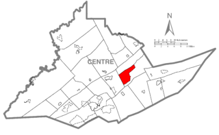
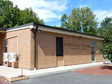
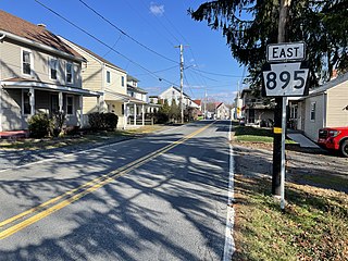
Zion is an unincorporated community and census-designated place (CDP) in Centre County, Pennsylvania, United States.

<span class="mw-page-title-main">Slabtown, Pennsylvania</span> Census-designated place in Pennsylvania, United States

Slabtown is a census-designated place in Columbia County, Pennsylvania, United States. It is part of Northeastern Pennsylvania. The population was 156 at the 2010 census. It is part of the Bloomsburg-Berwick micropolitan area.

<span class="mw-page-title-main">Marshallton, Pennsylvania</span> CDP in Pennsylvania, United States

Marshallton is a census-designated place (CDP), located in Coal Township, in Northumberland County, Pennsylvania, United States. The population was 1,441 at the 2010 census.

Altamont is a census-designated place (CDP) in Schuylkill County, Pennsylvania, United States. The population was 2,689 at the 2000 census.

<span class="mw-page-title-main">Branchdale, Pennsylvania</span> CDP in Pennsylvania, United States

Branchdale is a census-designated place (CDP) in Schuylkill County, Pennsylvania, United States. The population was 436 at the 2000 census.

<span class="mw-page-title-main">Brandonville, Pennsylvania</span> CDP in Pennsylvania, United States

Brandonville is a census-designated place (CDP) in East Union Township in Schuylkill County, Pennsylvania. The population was 180 at the 2020 census.

<span class="mw-page-title-main">Delano, Pennsylvania</span> CDP in Pennsylvania, United States

Delano is a census-designated place (CDP) in Schuylkill County, Pennsylvania, United States. The population was 377 at the 2000 census.

<span class="mw-page-title-main">Donaldson, Pennsylvania</span> CDP in Pennsylvania, United States

Donaldson is a census-designated place (CDP) in Frailey Township, Schuylkill County, Pennsylvania, United States. The population was 325 at the 2000 census.

Englewood is a census-designated place (CDP) in Schuylkill County, Pennsylvania, United States. The population was 484 at the 2000 census.

Forestville is a census-designated place (CDP) in Schuylkill County, Pennsylvania, United States. The population was 431 at the 2000 census.

Fountain Springs is a census-designated place in Butler Township, Schuylkill County, Pennsylvania, United States. The population was 100 at the 2000 census.

<span class="mw-page-title-main">Friedensburg, Pennsylvania</span> CDP in Pennsylvania, United States

Friedensburg is a census-designated place (CDP) in Schuylkill County, Pennsylvania, United States. The population was 828 at the time of the 2000 census.

<span class="mw-page-title-main">Lake Wynonah, Pennsylvania</span> CDP in Pennsylvania, United States

Lake Wynonah is a census-designated place (CDP) in Schuylkill County, Pennsylvania, United States. The population was 1,961 at the 2000 census, and 2,640 at the 2010 census. Lake Wynonah is a gated community with two lakes, Fawn Lake and Lake Wynonah, and as of July 2008, there are over 1200 homes and 1500 members. It is in South Manheim and Wayne Townships.

Ravine is a census-designated place (CDP) in Schuylkill County, Pennsylvania, United States. The population was 629 at the 2000 census.

<span class="mw-page-title-main">Sheppton, Pennsylvania</span> CDP in Pennsylvania, United States

Sheppton is a census-designated place (CDP) in Schuylkill County, Pennsylvania, United States. The population was 239 at the 2000 census.

Summit Station is a census-designated place (CDP) in Schuylkill County, Pennsylvania, United States. The population is 174 as of the 2010 census.

<span class="mw-page-title-main">Valley View, Schuylkill County, Pennsylvania</span> CDP in Pennsylvania, United States

Valley View is a census-designated place (CDP) in Schuylkill County, Pennsylvania, United States. The population was 1,677 at the 2000 census.

<span class="mw-page-title-main">Gorham (CDP), Maine</span> Census-designated place in Maine, United States

Gorham is a census-designated place (CDP) in the town of Gorham, in Cumberland County, Maine, United States. The population was 6,882 at the 2010 census. It is part of the Portland–South Portland–Biddeford, Maine Metropolitan Statistical Area.

References

  1. "ArcGIS REST Services Directory". United States Census Bureau. Retrieved October 12, 2022.
  2. "Census Population API". United States Census Bureau. Retrieved Oct 12, 2022.
  3. "US Gazetteer files: 2010, 2000, and 1990". United States Census Bureau. 2011-02-12. Retrieved 2011-04-23.
  4. "Census of Population and Housing". Census.gov. Retrieved June 4, 2016.
  5. "U.S. Census website". United States Census Bureau . Retrieved 2008-01-31.